This is the 2nd time I've heard about this road. It is indeed supposed to be excellent. I'm close enough to have a look when the snow clears next year. Unless of course it's passable by 4WD now?In the West, a good alternative road, known largely to the locals, is to go from La Lécherette, past Lac de l'Hongrin, and through the mountain to Corbeyrier and ending at Yvorne near Aigle. I would highly recommend this road. The top part is a Swiss military training area and the road is in very good condition with wide sweeping bends. You then have fabulous views over Lake Geneva before the road becomes very narrow and winding as it decends through a series of tunnels to Yvorne. On some maps this road is marked as closed - it can be during the week if the army are playing - but on weekends it is usually open.

- Forums
- Trip Reports, Travel Information & Advice
- Open invite trips
- Previous Trips
- Swiss Alps 2009, let's do it 11th-18th Sept 2009
You are using an out of date browser. It may not display this or other websites correctly.
You should upgrade or use an alternative browser.
You should upgrade or use an alternative browser.
Proposed route
- Thread starter Magnum
- Start date
Indeed, when it's open it's a good one. Here's an overview of the section to Yvorne and a few more roads around that area:
http://www.bestbikingroads.com/motorcyclegps.php?n=La-Lecherette-Yvorne&code=36da40
David
http://www.bestbikingroads.com/motorcyclegps.php?n=La-Lecherette-Yvorne&code=36da40
David
Onwalkabout
Registered user
Where are you Magnum? I work out of Geneva and if you feel like a run when the snows clear, let me know and I'm happy to show the way. I don't know about 4x4 but the top section at least should be passable thanks to the army.
Magnum,
I like to take in the scenery, take loads of photies etc etc and my wife and I do not fancy endless riding. Be frank with me, what sort of progress will you be making and could I fall back and regroup later as necessary?
Need to know these sort of issues you see
I like to take in the scenery, take loads of photies etc etc and my wife and I do not fancy endless riding. Be frank with me, what sort of progress will you be making and could I fall back and regroup later as necessary?
Need to know these sort of issues you see
Last time we clocked around 120-350km per day. Remember there were no motorways allowed and the entire route was mainly mountain roads and passes. It's a great formula that allows you to experience far better motorcycling and the intention is to repeat it for this trip.Magnum,
I like to take in the scenery, take loads of photies etc etc and my wife and I do not fancy endless riding. Be frank with me, what sort of progress will you be making and could I fall back and regroup later as necessary?
Need to know these sort of issues you see
120km is nowhere near enough with riding taking up around 2 1/2 hours of the day. 350km took around 8-9 hours which is fine for a day but is probably too much on these roads to be a sensible average. I found 225-250'ish was about right in terms riding/sight-seeing time. So probably around 5-6 hours a day riding.
Don't forget we'll be split into slow, medium and fast groups.
An ideal day would go something like this.
8.30am - Breakfast
9.30am - Start riding
11am - Stop for a brew
11.30am - Resume riding
1pm - Lunch
2pm - Resume riding
3.30pm - Stop for a brew
4pm - Resume riding
6pm - Check in to hotel
7pm - Dinner
7pm-midnight - Legendary wine/beer consumption
 combined with talking complete crap about bikes/the good old days/other nonsense
The whole point is this. As long as we start the day together and then eat together of an evening there's ample scope to please the tourists and hard-core riders

BM Bandit
Registered user
Magnum
Looks like a great plan for the daily ride. I must admit that I am hoping the times and stops on your plan are for the slow riders.
Clearly we all start and intend to finish at the same place, I just wouldn't want the slow group to be pulling in at 9pm every night completely knackered with 'hair-pin' syndrome.
Would it be possible to limit the distance between A (the start) and B (the finish) to be no more than 200km along the most direct and scenic route, but rideable at slower speeds in the timeplan you suggested.
The fast group could then either have longer breaks, more breaks or add a few extra Kms if they wanted and still finish by 6.00pm.
I suppose I am trying to say that I would probably prefer to be riding no more than 4 to 5 hours very concentrated riding a day, which will leave me with enough energy and time to bore everyone to death when we sample the local refreshments.
Your thoughts committed's and maybe's.
BM Bandit
")
Looks like a great plan for the daily ride. I must admit that I am hoping the times and stops on your plan are for the slow riders.
Clearly we all start and intend to finish at the same place, I just wouldn't want the slow group to be pulling in at 9pm every night completely knackered with 'hair-pin' syndrome.
Would it be possible to limit the distance between A (the start) and B (the finish) to be no more than 200km along the most direct and scenic route, but rideable at slower speeds in the timeplan you suggested.
The fast group could then either have longer breaks, more breaks or add a few extra Kms if they wanted and still finish by 6.00pm.
I suppose I am trying to say that I would probably prefer to be riding no more than 4 to 5 hours very concentrated riding a day, which will leave me with enough energy and time to bore everyone to death when we sample the local refreshments.
Your thoughts committed's and maybe's.
BM Bandit
It wouldn't be sensible to limit each days riding to 200km for the sake of slower riders.
However, do not be concerned.
A typical day's riding will not be A to B in a straight line. Due to the terrain there is ample scope to "cut corners" and take a more direct route from morning departure to evening destination. This means that whilst the full day's itinerary might involve 250km of amazing mountain passes and B-roads, it would be perfectly feasable to slow down a bit, take more time off the bike and miss off a section or two of the planned route for the day.
End result - everyone's happy and we all meet up later as planned
This works well because it's exactly what my Mrs did earlier this year on my tour of the Alps.
Hope this helps.
PS - This arrangement will not get you out of buying your fair share of rounds 
However, do not be concerned.
A typical day's riding will not be A to B in a straight line. Due to the terrain there is ample scope to "cut corners" and take a more direct route from morning departure to evening destination. This means that whilst the full day's itinerary might involve 250km of amazing mountain passes and B-roads, it would be perfectly feasable to slow down a bit, take more time off the bike and miss off a section or two of the planned route for the day.
End result - everyone's happy and we all meet up later as planned
This works well because it's exactly what my Mrs did earlier this year on my tour of the Alps.
Hope this helps.
PS - This arrangement will not get you out of buying your fair share of rounds
Magnum, I have started plotting your waypoints in Mapsource, so that I can get a feel of the distances involved. Mapsource will not plot, what seems a sensible route from Bormio to Stelvio, even if I edit preferences and take out 'seasonal closures.' As you see below, it plots a route all over the eastern alps:

Is there something that you know about the SS38, which stops Mapsource from using it ?
I am starting to get very mentally fuelled for this trip, but our British £ is being truly hammered.
Is there something that you know about the SS38, which stops Mapsource from using it ?
I am starting to get very mentally fuelled for this trip, but our British £ is being truly hammered.
BM Bandit
Registered user
Magnum
Excellent, you've got everything covered. Just nine months to wait.
BM Bandit
Excellent, you've got everything covered. Just nine months to wait.
BM Bandit
The routing issue via mountain passes is a common problem with mapping applications. Otherwise I could plan the intire route via Google Maps. Not sure what the solution is here except fire up my old laptop and use OnRoute.Magnum, I have started plotting your waypoints in Mapsource, so that I can get a feel of the distances involved. Mapsource will not plot, what seems a sensible route from Bormio to Stelvio, even if I edit preferences and take out 'seasonal closures.' As you see below, it plots a route all over the eastern alps:
Is there something that you know about the SS38, which stops Mapsource from using it ?
I am starting to get very mentally fuelled for this trip, but our British £ is being truly hammered.
The exchange rate is a bitch, but it will improve by September. Present levels are hurting the Swiss economy and they will not allow that to happen for long.
Magnum, I have started plotting your waypoints in Mapsource, so that I can get a feel of the distances involved. Mapsource will not plot, what seems a sensible route from Bormio to Stelvio, even if I edit preferences and take out 'seasonal closures.' As you see below, it plots a route all over the eastern alps:
Is there something that you know about the SS38, which stops Mapsource from using it ?
I am starting to get very mentally fuelled for this trip, but our British £ is being truly hammered.
GrinningGSer
Is this any help to you..?
TJ
Attachments
SPAINSKYWALKER
Guest
Hi Magnun,
I saw the map, but it´s very small to see the details. Can you public the http of google maps where you did it?
Thanks.
I must add the km from Madrid to Vevey (only 1475 ), and the same to back. Probably I`ll go 9th of september, to arrive to Vevey 10th in the night.
V`ssss from Spain
I saw the map, but it´s very small to see the details. Can you public the http of google maps where you did it?
Thanks.
I must add the km from Madrid to Vevey (only 1475
), and the same to back. Probably I`ll go 9th of september, to arrive to Vevey 10th in the night.V`ssss from Spain
All gone a bit quiet around here 
If there is a route plan available in some format I'd like to have a go at putting it together in Mapsource
If there is a route plan available in some format I'd like to have a go at putting it together in Mapsource
Thanks for the offer. Feel free to have a play around but I've also decided to plot it on a Windows PC I have even though Mac's are far better
I think the really detailed planning will start 1st April when numbers are confirmed. We have last years route as a starting point and over the last few months I've had the chance to visit some of the destinations in order to improve the route a little.
Here's a shot the missus took of me just over a week ago at the world's highest revolving restaurant above Saas-Fee. Would you believe it is 11,483 ft above sea level

The air was so thin I felt quite dizzy at times, but still managed to ski down. The lifts are open in summer so it would be a great place to visit
I think the really detailed planning will start 1st April when numbers are confirmed. We have last years route as a starting point and over the last few months I've had the chance to visit some of the destinations in order to improve the route a little.
Here's a shot the missus took of me just over a week ago at the world's highest revolving restaurant above Saas-Fee. Would you believe it is 11,483 ft above sea level
The air was so thin I felt quite dizzy at times, but still managed to ski down. The lifts are open in summer so it would be a great place to visit
All gone a bit quiet around here
If there is a route plan available in some format I'd like to have a go at putting it together in Mapsource
I can't commit yet, but I spent some time at Xmas plotting waypoints, so as to get an idea of potential distances
The gdb has so many waypoints, incl passes, 848kb that it exceeds the forum limit
p.m. me your email, if you would like to have a look at it for starters
Rabbitson. Will On-Route allow me to plot routes over mountain passes rather than divert the long way round like Mapsource and Google Maps?Magnum,
On-Route will give you some of the possibilities that you're missing but sadly it won't work on a Mac (unless you have an intel mac that can also run windows)
Whatton should be doing a review of On-Route on here soon so you can read a bit more about it then, in the meantime you can ask me any questions you have.
David
Hi there,
Here is what on-route suggests for the same start and end point:
(option 1 shown green and option 2 shown blue)
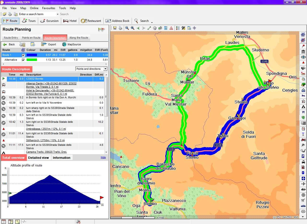
Although as I haven't tried all possible mountain pass combinations I can't answer directly about all scenerios but certainly it's better than MapSource or Google.
David
Here is what on-route suggests for the same start and end point:
(option 1 shown green and option 2 shown blue)
Although as I haven't tried all possible mountain pass combinations I can't answer directly about all scenerios but certainly it's better than MapSource or Google.
David
Interesting
If you have a spare few mins could you try routes through the flowing passes please, just to see if it will navigate them?
Furka
Grimsel
Gt San Bernard (pass not tunnel)
Oh and how much is onroute for forum members?
Cheers
If you have a spare few mins could you try routes through the flowing passes please, just to see if it will navigate them?
Furka
Grimsel
Gt San Bernard (pass not tunnel)
Oh and how much is onroute for forum members?
Cheers
Other Mountain Passes
Magnum,
Here's what I entered and what I got back:
Furkapass
Start : Gletsch
End : Realp
Result:
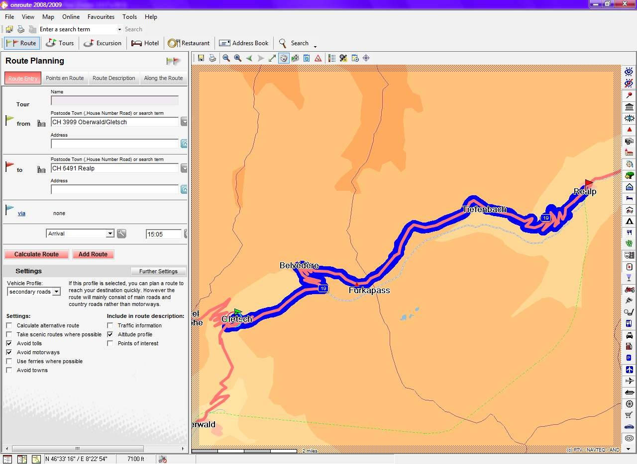
Magnum,
Here's what I entered and what I got back:
Furkapass
Start : Gletsch
End : Realp
Result:


Similar threads
- Replies
- 29
- Views
- 811
- Replies
- 13
- Views
- 408
- Replies
- 7
- Views
- 949
- Replies
- 5
- Views
- 592