Got the Salisbury Plain ordnance survey map

ELIMINATOR

Well-known member
UKGSer Subscriber
Joined
Sep 18, 2004
Messages
6,737
Reaction score
3
Location
Hampshire.
Ordnance survey, Explorer maps to be precise.

So, looking at the map, and seeing the symbols for "byway open to all traffic" icons criss crossing the plain. How negotiable are these for an off road novice on an 1150GS?

I'm thinking about doing this with my mate, he's on a 650 Transalp.

Just looking at the one that runs roughly N - S from The Bustard Inn to CHIRTON CP, that joins the "White Horse Trail" It might be too much, I haven't got a clue?

Aside from the odd UXB or tank, is this relatively easy to do?

Tyres on the bike are Conti Trail attack on the front and a Tourance on the back of mine.
 
You should be fine.

if it's the route i'm thinking of it's one of the main access roads through salisbury plain, and is quite well graded.

generally in this area, if a byway symbol are placed over a road (shown as a double dashed line in black), then they are usually quite ride-able on a big bike.
This time of year, If you go out after a few days with no rain, then there shouldn't be many places you won't be able to go on a big bike.

Just avoid the puddles.:eek:

White horse trail,which runs from near Westbury across to Netheravon should be easily rideable to. It's a road made from graded scalpings.

HTH

Nathan
 
Just looking at the one that runs roughly N - S from The Bustard Inn to CHIRTON CP, that joins the "White Horse Trail" It might be too much, I haven't got a clue?

Aside from the odd UXB or tank, is this relatively easy to do?
Yes it is fairly easy. About a third of the way up from Bustard, where there is a fork to the left around SU068494 there are plenty of "tanks" over to the right.
 
Near the observation posts you mean? What's there then, tanks that have been used as target practice?
 
i would check with s.p.t.a (salisbury plain training area) which i belive is in westdown camp
 
Two of us are exploring this area tomorrow morning,
I have already sought advice from Clive and some of the exit tracks that I planned are potentially hard to find

We are then heading south west to enter the graded tracks from here heading north again.

I am not intending to to d anything difficult

pm me if you are interested in joining us:D
 
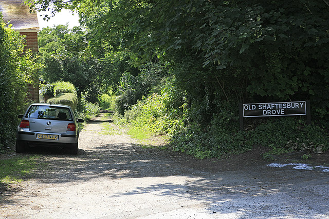
just found the "Old Shaftsbury Drove" track from Salisbury heading, err, to Shaftsbury.

What's this like then, just sounds good to follow a track that might be 100's of years old.
 
just found the "Old Shaftsbury Drove" track from Salisbury heading, err, to Shaftsbury.

What's this like then, just sounds good to follow a track that might be 100's of years old.

It's like the first half of this video:
<object width="425" height="344"><param name="movie" value="http://www.youtube.com/v/wgfL7m2e0Uo&hl=en&fs=1&"></param><param name="allowFullScreen" value="true"></param><param name="allowscriptaccess" value="always"></param><embed src="http://www.youtube.com/v/wgfL7m2e0Uo&hl=en&fs=1&" type="application/x-shockwave-flash" allowscriptaccess="always" allowfullscreen="true" width="425" height="344"></embed></object>


Most of Salisbury plain is perfect for GSs and novices. Nearly all difficult/muddy bits on the training area can be bypassed on the all weather tracks alongside them.
 
These are all on Shaftesbury Drove also:
7c1cf201.jpg

285f9fc2.jpg

536315e9.jpg

f83edc91.jpg

7cf9f18e.jpg

fa618187.jpg

08409b10.jpg

6bdd0b16.jpg

813f639e.jpg

fbe3c72a.jpg

023afb5a.jpg


South of Shaftesbury drove is the Ox Drove which you can use to get back East. It isn't as easy, but it is doable on a GS, however the larger puddles on it aren't. DO NOT ATTEMPT THEM. All have paths past except the one right at the Easternmost end tho.

These are on the track over larkhill impact area:
DSC00698.jpg

DSC00697.jpg

DSC00696.jpg

It's mostly tarmac with some big potholes, and some hardpacked gravel to the north.


Take a look at the tracks on Bulford Ranges.
bda57aff.jpg

30235191.jpg

94843038.jpg

Amesbury16-05-09.jpg

All the above route is ok on a GS when relatively dry. MOST of it is ok in the wet too, however they can get a little slippery when wet (especially if not on TKCs) but they are fairly level and nice easy going on a GS.
They can get a tad damp in winter at the small fords tho.:augie

DSC00695.jpg

DSC00694.jpg

DSC00693.jpg

DSC00692.jpg

DSC00691.jpg

DSC00690.jpg

DSC00689.jpg

DSC00688.jpg

DSC00687.jpg

DSC00686.jpg


These are on the track from the East of Boscombe Down airfield to Shipton Bellenger.
DSC00683.jpg

DSC00682.jpg

DSC00681.jpg

DSC00679.jpg

DSC00676.jpg

RIP buddy.

The tracks N and S of Yarnbury Castle:
http://www.multimap.com/maps/?qs=ch...mation&loc=GB:51.16422:-1.94828:14|chitterne|
Are easy enough too. Again they get a tad slippery when wet tho.
The second half of the vid in my last post was shot on this track. You can avoid the big puddle tho. ;)

And of course there is the classic past stonehenge:
http://www.multimap.com/maps/?qs=ch...mation&loc=GB:51.17046:-1.83617:14|chitterne|
Ride it while you still can.

I will happily show you around sometime if you want fella.
I doubt you will tho. :)
 
Today I rode the Shaftsbury Drove:eek:

My previous off road experience on 1150 was riding across the field at Llangollen to pitch the tent.

We started at salisbury, the very first bit. sheeeeeeeeeeeeeeeeeeeeeeit! luckily this stretch was very short!

Hmm, a bit scary in places big potholes (for me anyway) then there was a big mud hole (again for me:p)

I enjoyed chasing a bird along an avenue of trees at about 35 mph, also amused me the 2 birds flying about a foot above the ground in front of me.

We turned off just before the end, i think it was the end according to a cafe owner in Salisbury who gave us directions. Must have been about a mile short of the end, I was just too nackered:rolleyes:

What I want to know is, how did that bloody great big old fashioned caravan (the sort that looks like it should be towed by a steam engine!) and lorry get to where it was parked, at the top of a valley?

Anyway, I'm in one piece, so is the just hosed down GS.
I was sooooooooooooooo convinced that a cylinder head was going to clobber the side of one of the ruts and have me off.

Still at least I now know to a lesser degree:p what a GS can handle.
 
What I want to know is, how did that bloody great big old fashioned caravan (the sort that looks like it should be towed by a steam engine!) and lorry get to where it was parked, at the top of a valley?

Grid ref. SU 019279. Well it looks as if it is the right place, steep sides:rolleyes:
 
194718_2c0f0fce.jpg


This was the starting point in Salisbury / Harnham. SU134283

Looking at the map again, i guess we must have got onto tarmac a bit short of Ludwell. This might have been the A30, just wish i could remember.:blast
 
What I want to know is, how did that bloody great big old fashioned caravan (the sort that looks like it should be towed by a steam engine!) and lorry get to where it was parked, at the top of a valley?

We rode the Shaftsbury Drove and Ox Drove on Saturday. Couple of GS 1150 ADV's in our group. No problems anywhere. Unless it has been raining heavily I would say it is ideal for GSes.

<object width="425" height="344"><param name="movie" value="http://www.youtube.com/v/SR1fD44dQkM&hl=en&fs=1&"></param><param name="allowFullScreen" value="true"></param><param name="allowscriptaccess" value="always"></param><embed src="http://www.youtube.com/v/SR1fD44dQkM&hl=en&fs=1&" type="application/x-shockwave-flash" allowscriptaccess="always" allowfullscreen="true" width="425" height="344"></embed></object>

You mean this caravan ....
 

Attachments

  • caravan.jpg
    caravan.jpg
    72.5 KB · Views: 889


Back
Top Bottom