
- Joined
- Oct 10, 2004
- Messages
- 3,569
- Reaction score
- 28
The desert artwork of Hannesjörg Voth

I first saw a photo of one of Hannesjörg Voth's desert homes in a French-language guide book by Jacques Gandini. Last January I made an attempt to reach one of the homes on a fully-laiden BMW 1200GSA. Fortunately I had enough sense to turn back before tackling the sandy river crossing.
Later that trip I was snow-bound in Azrou, chatting to a German couple by the fire in the Panorama Hotel when the guy mentioned they had a home in the desert near Erfoud. He was amazed when I said I had tried to reach it the week before. Hansjörg said there were a variety of tracks but they kept changing with the drifting sand dunes and the course of the river bed. A few days later I tried again without luggage, but again turned back by the danger of being stuck by myself in the fesh fesh (fine sand like talcum powder).
This trip I was on a Honda XR400R, so determined to make it. It makes a really interesting side trip from Erfoud, so I've included waypoints for intrepid GS adventurers.
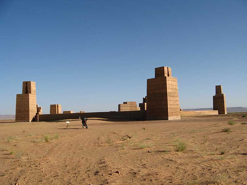
Leaving Erfoud, head 25 km west on the road to Tinerhir. After going through a fairly large town, on the right you'll see lines of what appear to be wells but are actually khetteras--underground water canals. As you approach a couple of berber tents by some of the best preserved khetteras, scan the horizon to the north (right) for the structure below (taken with 6-times zoom).


Stadt des Orion (Orion Constellation)
Visible in the winter months and known to us as Orion the Hunter from Greek mythology, the three stars making up Orion's belt are most recognisable.
Leave the road by the track some 200m west of the last Berber tent at N31 31.809 W4 30.063 and follow your nose towards the waypoint for the 'Stadt des Orion' at N31 36.783 W4 31.538. You'll need to cross the Oued Rheris at some point.
This is an artistic conception and doesn't include any living accommodation

You can climb the towers

The three stars of Orion's belt. You can see the Golden Spiral in the distance, and I must have almost passed it on the way it.

This is what fesh fesh looks like. Beware.
Goldene Spirale (The Golden Spiral)
Not so impressive on the ground as the other structures, this lies at N31 35.505 W4 32.099


The metal covers are windows for when the spiral is being occupied

The entrance to the building is at the top
Himmelstreppe (Sky Stairway)
Built in 1984, this lies at N31 34.890 W4 28.720


Standing 16m tall, it dwarfs the XR400.

There's 52 steps up to the entrance at the top. And at 3000' altitude it can make you puffed.
Back to the road
Your objective is N31 31.640 W4 27.960. Try heading directly east for a bit to pick up a track. Mind you, the one I picked ended up disappearing under a sand dune!

You'll need to cross the Oued Rhesis again.
More information
Some background info: http://www.hannsjoerg-voth.de/marokko.html and http://www.kyra-maralt.com/Archiv/Voth.html
Put them through Babelfish (German to English web page translation) at http://babelfish.altavista.com/babelfish/tr
Map and GPS waypoints/track

Garmin file: http://www.zroadster.net/tim/gs/maroc-tim-voth-log.gdb
Because of the lack of clearly defined tracks and the problems with river crossing and fine sand, I classed this as a BLACK piste, not to be undertaken on a GS fully laden or alone. In my classifications GREEN=extra smooth novice piste, BLUE=normal piste, RED=some technical skill required, BLACK=difficult.
Tim
I first saw a photo of one of Hannesjörg Voth's desert homes in a French-language guide book by Jacques Gandini. Last January I made an attempt to reach one of the homes on a fully-laiden BMW 1200GSA. Fortunately I had enough sense to turn back before tackling the sandy river crossing.
Later that trip I was snow-bound in Azrou, chatting to a German couple by the fire in the Panorama Hotel when the guy mentioned they had a home in the desert near Erfoud. He was amazed when I said I had tried to reach it the week before. Hansjörg said there were a variety of tracks but they kept changing with the drifting sand dunes and the course of the river bed. A few days later I tried again without luggage, but again turned back by the danger of being stuck by myself in the fesh fesh (fine sand like talcum powder).
This trip I was on a Honda XR400R, so determined to make it. It makes a really interesting side trip from Erfoud, so I've included waypoints for intrepid GS adventurers.
Leaving Erfoud, head 25 km west on the road to Tinerhir. After going through a fairly large town, on the right you'll see lines of what appear to be wells but are actually khetteras--underground water canals. As you approach a couple of berber tents by some of the best preserved khetteras, scan the horizon to the north (right) for the structure below (taken with 6-times zoom).
Stadt des Orion (Orion Constellation)
Visible in the winter months and known to us as Orion the Hunter from Greek mythology, the three stars making up Orion's belt are most recognisable.
Leave the road by the track some 200m west of the last Berber tent at N31 31.809 W4 30.063 and follow your nose towards the waypoint for the 'Stadt des Orion' at N31 36.783 W4 31.538. You'll need to cross the Oued Rheris at some point.
This is an artistic conception and doesn't include any living accommodation
You can climb the towers
The three stars of Orion's belt. You can see the Golden Spiral in the distance, and I must have almost passed it on the way it.
This is what fesh fesh looks like. Beware.
Goldene Spirale (The Golden Spiral)
Not so impressive on the ground as the other structures, this lies at N31 35.505 W4 32.099
The metal covers are windows for when the spiral is being occupied
The entrance to the building is at the top
Himmelstreppe (Sky Stairway)
Built in 1984, this lies at N31 34.890 W4 28.720
Standing 16m tall, it dwarfs the XR400.
There's 52 steps up to the entrance at the top. And at 3000' altitude it can make you puffed.
Back to the road
Your objective is N31 31.640 W4 27.960. Try heading directly east for a bit to pick up a track. Mind you, the one I picked ended up disappearing under a sand dune!
You'll need to cross the Oued Rhesis again.
More information
Some background info: http://www.hannsjoerg-voth.de/marokko.html and http://www.kyra-maralt.com/Archiv/Voth.html
Put them through Babelfish (German to English web page translation) at http://babelfish.altavista.com/babelfish/tr
Map and GPS waypoints/track
Garmin file: http://www.zroadster.net/tim/gs/maroc-tim-voth-log.gdb
Because of the lack of clearly defined tracks and the problems with river crossing and fine sand, I classed this as a BLACK piste, not to be undertaken on a GS fully laden or alone. In my classifications GREEN=extra smooth novice piste, BLUE=normal piste, RED=some technical skill required, BLACK=difficult.
Tim


")


