Lord Vader
Registered user
Would anyone on here know if you can get from Bormio to St.Moritz via the SS301? If I go on google earth it looks like there is a bit missing on top
Cheers Pete
Cheers Pete


Yes and than you go on google earth to have a look at the route and hey fekking presto you see a stretch of road is missing (no cloud cover) hence me askingYou serious?
Have you never heard of google maps, it's amazing...you go into google, hit maps.... you type in Bormio and then St Moritz and click on GET DIRECTIONS, and hey fekking presto it gives you a route along the SS301.................

 ) and for some strange reason I can not use the search function on here on my phone


Would anyone on here know if you can get from Bormio to St.Moritz via the SS301? If I go on google earth it looks like there is a bit missing on top
Cheers Pete
Yep just couldnt see the tunnels on my phone. On google earth and on my map it looked like that it might not be possible to get across there. Had a look at a friends laptop and seen the tunnels, cheers guys.Do we presume you don't have a GPS with Mapping or... a Map?
Anyway - even if you're doing this on your phone, search works on my phone with Tapatalk.
I think you'll find the missing bits of the road are...tunnels.
Yep just couldnt see the tunnels on my phone. On google earth and on my map it looked like that it might not be possible to get across there. Had a look at a friends laptop and seen the tunnels, cheers guys.
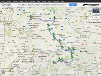
Does anyone know how to link gogle maps so some of you could maybe have a look at my route and let me know what I maybe missed on "have to see" places?
Cheers
Just trying to get a map up
https://maps.google.co.uk/maps?sadd...lH0ldQ&dirflg=h&via=7,12,16,18,19,23&t=m&z=11
the second part
https://maps.google.co.uk/maps?sadd...8zLpG9RzGgG9sQ1dQiBA&dirflg=h&via=1,5&t=m&z=7
How do you get the proper maps up and not just a link????
p.s.oh and i know the 301 is not on there in the way i was asking about.Cheers

But earlier comment notwithstanding, this would be one of the maps as an image: