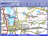
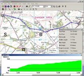
I have the Anquet (
http://www.anquet.co.uk/) 1:50000 map series for GB south. This is a good product. The mapping is good and the CD includes quite effective 3D mapping. Once you have created a new route all the usual route information is available; length, height gain, time, etc.
You can view a 3D image of the routes you have created and there is a nifty 'walk route' feature which animates the 3D map as you travel along - this clearly shows the terrain along your route. There is also a place name search.
It works fine with Garmin GPS V and 196 (there really should be no problem with any of the Garmin units). You can download waypoints to your GPS as well as view the contents of your GPS.
It is not a bad product but of course the spatial data is licensed from Ordnance Survey (see below) and so it comes with copy protection and requires unlock codes. The original licensing terms are quite onerous - a single unlock code for a single PC. When I realised this I wrote a mail to the support desk indicating that I thought this was unfair as I wanted to install the software on a laptop for when I was travelling. They responded well and provided an additional unlock code.
All Ordnance Survey digital mapping is is subject to Crown Copyright. This is quoted on their web site:
"Although Ordnance Survey is a UK government agency, we cover our operating costs through sales of products, services and copyright licenses. Since April 1999 when we gained our Trading Fund status, we now have greater responsibility for our own finances and planning, as well as extra freedom to develop new initiatives." (
http://www.ordnancesurvey.co.uk/oswebsite/aboutus/whoweare/)
This means no free (of cost or copyright) digital mapping data is provided by them. If you need the data then you have to pay for a license. This is in stark contrast to the US where all government collected data is available free of charge and is in the public domain. Multimap, Anquet Maps, Memory Map, etc. have all licensed the spatial data for their applications from the Ordnance Survey.
Ordnance Survey themselves have a mapping service on their web site here
http://www.ordnancesurvey.co.uk/oswebsite/getamap/ which works OK, but it is a bit slow (wow - all those terms and conditions just to have a look at a map ...)


")
") They actually divide the UK into 12 regions, at £40 each, or £120 for six, or £220 for all 12.
They actually divide the UK into 12 regions, at £40 each, or £120 for six, or £220 for all 12.