GARMIN STREETPILOT III (3) DELUXE + NEW MetroGuide V5 and V6 MapSource
The unit is mine and has very few blemishes on it.
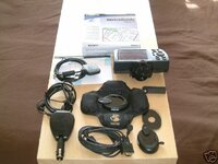
The unit is complete with the following items:
StreetPilot III with portable antenna as well as remote antenna that did not come with the original package.
PC interface cable
Dashboard mount
Portable Mount (bean bag mount)
External speaker with 12-volt cigarette lighter adapter
Owner's manual
Quick reference guide
USB data card programmer
Atlantic Autoroute Basemap
MapSource MetroGuide Europe V5 and V6 Software
128 MB datacard
Please Note: All this comes in the original box and I will throw in a set of batteries.
I also have the Touratech monut which can be had for an extra £30.
The MetroGuide MapSource product provides map data covering the whole of Europe (which includes UK, Germany, Italy, France, Benelux, Switzerland, Spain, Austria, Sweden, Denmark, Portugal, Finland and Norway).
The Navtech 2003 maps contain street level data, with street names together with road numbers for A & B roads and motorways. Rivers, coastlines and National Park boundaries are also displayed, together with ‘points of interest’ such as shopping centres, petrol stations, hotels and restaurants.
The MetroGuide becomes particularly useful if you are trying to find a particular address. Enter the house number and street name and it’s precise location and direction will be displayed on the map.
The trip and waypoint management software that allows you to transfer and create waypoints, routes and the map data itself from PC to your GPS is also included.
The following is from the Garmin website www.garmin.com
Imagine never being lost while driving. Garmin® makes it possible. Meet the StreetPilot III - the ultimate travelling companion and guide. Create a route and then put your mind on cruise as you follow clear, accurate, voice-prompted turn-by-turn directions to safely reach your destination. The simple, intuitive menus of the StreetPilot III offer access to the shortest and fastest routes, directions, and estimated arrival time of your intended destination. Automated voice prompts alert you to upcoming turns, course deviation, and distance to final destination. At the touch of a button, view the locations of all the nearest highway exits, gas stations, restaurants, ATMs, hospitals, and rest areas on a full-color L CD. Just place the portable system on the dash of any vehicle, and enjoy stress-free driving and peace of mind—without any costly service charges or hook-up fees.
• StreetPilot III with portable antenna • PC interface cable • Dashboard mount • Portable Mount (bean bag mount) • External speaker with 12-volt cigarette lighter adapter • Owner's manual • Quick reference guide • USB data card programmer and Atlantic Autoroute basemap.
Navigation Features
Routes: Automatically calculated with turn-by-turn instructions. Up to 50 stored. Using built-in basemap, routes include interstates, highways and major thoroughfares. With detailed data from CD-ROM, routes include residential street-level detail within metropolitan areas.
Voice: Navigation instructions and warnings
Waypoints: 500 with name and graphic symbol
Track log: 2000 track log points
Trip computer: Resettable odometer, timers, average and maximum speeds
GPS Performance GPS performance Receiver: Differential-ready 12 parallel channel GPS receiver continuously tracks and uses up to 12 satellites to compute and update your position
Acquisition times:
* Warm: Approximately 15 seconds * Cold: Approximately 45 seconds * AutoLocate®: Approximately 5 minutes
Update rate: 1/second, continuous
GPS Accuracy:
* Position: < 15 meters, 95% typical* * Velocity: 0.05 meter/sec steady state
DGPS Accuracy: * Position: 3-5 meters, 95% typical* * Velocity: 0.05 meter/sec steady state
Dynamics: 6g’s
Interfaces: RS232 with NMEA 0183
Antenna: Detachable with standard BNC-type connector
Physical Size: 3.2"H x 6.8"W x 2.6"D (8.0 x 17.3 x 6.5 cm)
Weight: 1.4 pounds (635 g)
Display:
* 3.4"W x 1.8"H (8.6 x 4.5 cm) * (305 x 160 pixels), high-contrast, * 16-color LCD with backlighting
Case: Rugged; fully gasketed
Temp. range: 5°F to 158°F (–15°C to 70°C)
Data storage: Indefinite; no memory battery required
Map storage: Data cards store detailed map data
Power Source: 6 AA batteries or 12-volt adapter cable
Battery life: 2–20 hours based on backlight setting
Price 350 + Postage
Please PM Me if you need any further details or ask anyone else on this forum if you are not sure how fantastic this pirce of kit is.
The unit is mine and has very few blemishes on it.
The unit is complete with the following items:
StreetPilot III with portable antenna as well as remote antenna that did not come with the original package.
PC interface cable
Dashboard mount
Portable Mount (bean bag mount)
External speaker with 12-volt cigarette lighter adapter
Owner's manual
Quick reference guide
USB data card programmer
Atlantic Autoroute Basemap
MapSource MetroGuide Europe V5 and V6 Software
128 MB datacard
Please Note: All this comes in the original box and I will throw in a set of batteries.
I also have the Touratech monut which can be had for an extra £30.
The MetroGuide MapSource product provides map data covering the whole of Europe (which includes UK, Germany, Italy, France, Benelux, Switzerland, Spain, Austria, Sweden, Denmark, Portugal, Finland and Norway).
The Navtech 2003 maps contain street level data, with street names together with road numbers for A & B roads and motorways. Rivers, coastlines and National Park boundaries are also displayed, together with ‘points of interest’ such as shopping centres, petrol stations, hotels and restaurants.
The MetroGuide becomes particularly useful if you are trying to find a particular address. Enter the house number and street name and it’s precise location and direction will be displayed on the map.
The trip and waypoint management software that allows you to transfer and create waypoints, routes and the map data itself from PC to your GPS is also included.
The following is from the Garmin website www.garmin.com
Imagine never being lost while driving. Garmin® makes it possible. Meet the StreetPilot III - the ultimate travelling companion and guide. Create a route and then put your mind on cruise as you follow clear, accurate, voice-prompted turn-by-turn directions to safely reach your destination. The simple, intuitive menus of the StreetPilot III offer access to the shortest and fastest routes, directions, and estimated arrival time of your intended destination. Automated voice prompts alert you to upcoming turns, course deviation, and distance to final destination. At the touch of a button, view the locations of all the nearest highway exits, gas stations, restaurants, ATMs, hospitals, and rest areas on a full-color L CD. Just place the portable system on the dash of any vehicle, and enjoy stress-free driving and peace of mind—without any costly service charges or hook-up fees.
• StreetPilot III with portable antenna • PC interface cable • Dashboard mount • Portable Mount (bean bag mount) • External speaker with 12-volt cigarette lighter adapter • Owner's manual • Quick reference guide • USB data card programmer and Atlantic Autoroute basemap.
Navigation Features
Routes: Automatically calculated with turn-by-turn instructions. Up to 50 stored. Using built-in basemap, routes include interstates, highways and major thoroughfares. With detailed data from CD-ROM, routes include residential street-level detail within metropolitan areas.
Voice: Navigation instructions and warnings
Waypoints: 500 with name and graphic symbol
Track log: 2000 track log points
Trip computer: Resettable odometer, timers, average and maximum speeds
GPS Performance GPS performance Receiver: Differential-ready 12 parallel channel GPS receiver continuously tracks and uses up to 12 satellites to compute and update your position
Acquisition times:
* Warm: Approximately 15 seconds * Cold: Approximately 45 seconds * AutoLocate®: Approximately 5 minutes
Update rate: 1/second, continuous
GPS Accuracy:
* Position: < 15 meters, 95% typical* * Velocity: 0.05 meter/sec steady state
DGPS Accuracy: * Position: 3-5 meters, 95% typical* * Velocity: 0.05 meter/sec steady state
Dynamics: 6g’s
Interfaces: RS232 with NMEA 0183
Antenna: Detachable with standard BNC-type connector
Physical Size: 3.2"H x 6.8"W x 2.6"D (8.0 x 17.3 x 6.5 cm)
Weight: 1.4 pounds (635 g)
Display:
* 3.4"W x 1.8"H (8.6 x 4.5 cm) * (305 x 160 pixels), high-contrast, * 16-color LCD with backlighting
Case: Rugged; fully gasketed
Temp. range: 5°F to 158°F (–15°C to 70°C)
Data storage: Indefinite; no memory battery required
Map storage: Data cards store detailed map data
Power Source: 6 AA batteries or 12-volt adapter cable
Battery life: 2–20 hours based on backlight setting
Price 350 + Postage
Please PM Me if you need any further details or ask anyone else on this forum if you are not sure how fantastic this pirce of kit is.