The adult children and wife were watching something on the telly and I retired with a bottle Port to have a look at this........quite surprised it made any sense at all

Anyhow more Port off we go again. .
Going North and West. See routes above
Day1
On this route you haven’t long left Rosslare when you are heading towards the Wicklow mountains National Park. This incorporates a trip past Laragh and along Sally gap which was a famous stage in the old Circuit of Ireland Rally. The scenery is great. The last time I was on it was September 2023 and the temperature was 27 Celsius, but you'd not get that in May. Coming off the mountains you go over the Liffey and through Blessington which would be a good place to stop for sustenance. After Naas, which can be a bit busy, its a quick run along some R roads up to Carrick-on-Shannon this can be shortcutted by riding straight up the N4 skirting Mullingar but its not a very interesting road. There is also a shortcut from Mohill to Fenagh to miss Carrick-on Shannon. The run up to Ballinamore takes you past part of the Shannon-Erne waterway. Parts of the canal are level with the fields and you can't see the water. So occasionally you see a cabin cruiser that looks like its floating over a field.

en.wikipedia.org
Heading North from Ballinamore towards Enniskillen you head past Florencecourt, and Marble Arch Caves, which are well worth a visit if you have the time.
en.wikipedia.org
Discover magical moments in one of Europe`s finest show caves. Set in the heart of the Cuilcagh Lakelands UNESCO Global Geopark, the Marble Arch Caves pay homage to the fascinating secrets of a world of subterranean rivers, winding passages, lofty chambers and an array of delicate cave formations.

marblearchcaves.co.uk
Day2 Round Lough Erne and into Donegal
The first stop on this virtual route is the Cliffs of Magho Viewpoint via a forrest drive. At just under 1100ft, this gives fantastic Panoramic views of lower lough Erne with the Sperrins and Donegal hills in the distance. Near the viewpoint are memorials to two air crews (A short Sunderland and Catalina) who lost their lives flying back to the RAF coastal command bases for the North Atlantic at Castle Archdale and Killadeas. You can imagine with high ground so close to the landing sites a few miles away that navigation in foul weather would have been tricky.
The protection of the North Atlantic convoys was made possible by the cooperation of the "Neutral" Irish government at the time.
en.wikipedia.org
The next stop is just on an L road that gives Panoramic views of Lough Melvin and the surrounding hills.
Next is Eagles Rock which is a stack visible from a secluded valley with views to the surrounding mountains and cliffs
From there its a short journey to Gleniff Horseshoe which is a 6 mile loop giving great views of the Dartry Mountains, and Donegal Bay.
Its a longish run from Gleniff around the north of Lough Melvin to Belleek famous for its pottery and Crossing the Border twice to get into the town!! Just North of the town is the townland of Corlea the site of another Sunderland crash in 1944
Article by Ernesider about Chuck Singer and a flying boat accident near Belleek on 12 August 1944.
www.bbc.co.uk
Then its up through Pettigo and on to lough Derg. It is best known for St Patrick's Purgatory, a site of pilgrimage on Station Island in the lake. I'm not a religious person but the buildings on Station Island are an impressive site. Sort of like an Irish lake Bled.
en.wikipedia.org
Next is a run through Killeter forest (which is pretty remote.) and onto Donegal town and on to Assaranca Waterfall near Ardara. The route shows a stop at Dungloe but you could get accommodation at Donegal town, Killybegs Ardara Maghery or any of the small towns and hamlets up that coast.
Day3 Dungloe to Greencastle
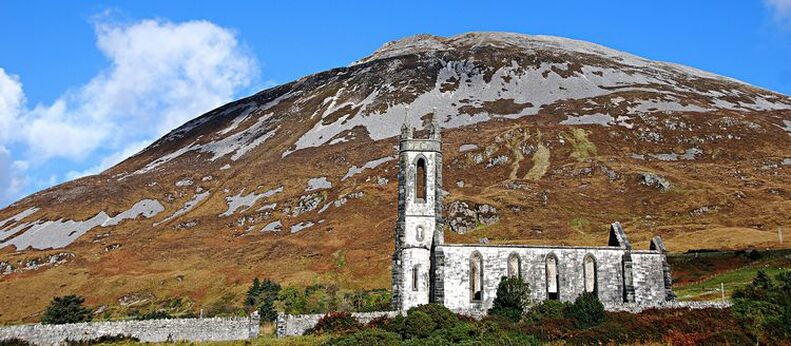
This section is firmly back on the Wild Atlantic Way, with twisty roads mountain views and seascapes. The first landmark is Dunlewey old church that stands at the foot of Mount Errigal between mountain and Lough
Nestled at the foot of Errigal (the hightest mountain in County Donegal) is Dunlewey and The Poisoned Glen. Here at the edge of Dulewey Lough is 'The Old Church'.
www.welovedonegal.com
After a run past Glenveagh national park (worth a visit if you have the time) its another scenic run through the mountains over the "Bridge of Tears" and back down towards the sea.
en.wikipedia.org
Then its through Dunfanaghy (Patsy Dans is a good place for a pint if your there at the right time of the day and you can get a Pizza from the Rusty Oven) and more mountainscapes and seascapes on the way to the Harry Blaney bridge which was opened in 2009 and saves a large detour through Milford to get to the Fanad Peninsula. If it was a choice of missing Fanad head or Malin Head Id chose Malin as Fanad is the more picturesque of the two.
Step back in time, hear stories about light-keepers in days gone by and climb to the top of tower for spectacular views of land and sea.

fanadlighthouse.com
Then its down the other side of the peninsula through Portsalon (Portsalon Golf club is a good spot for food and they don't seem to mind feeding someone who arrives by motorcycle.) then past Ballymastocker beach and viewpoint and up over Knockalla which has great views over Lough Swilly and was a famous stage on the Circuit of Ireland Rally and the Donegal Rally.
Then its a quick wizz down to Letterkenny and up through Buncrana to Mamore Gap (which gives great views of the Atlantic traveling north) and on to Malin Head (hold on to your hat) the most northerly point in Ireland.
The Route finishes in Greencastle as its near the ferry across the Foyle but you could stay anywhere on the Inishown peninsula and there is plenty of choice.
Day4 Magilligan to Larne
This area has been the subject of numerous day trips for me over the years and I know it very well so here goes. When you get off the ferry from Greencastle to Magilligan point there are the remains of an old Martello Tower.
The first stop is Binevenagh viewpoint. This is accessed up a mile long gravel road but its accessible on any bike. There are spectacular views from here, at over 1200ft elevation, of Lough foyle, the Donegal mountains and the Magilligan peninsula. (dont fall off the 300ft cliffs
)
https://en.wikipedia.org/wiki/Binevenagh
Only a mile or tow down the road is Gortmore Viewpoint with the sculpture of Manannan Mac Lir
Gortmore's superb Viewpoint situated on the Bishop's Road on the Binevenagh Loop, as part of the Causeway Coastal Route overlooks Magilligan Point,…

discovernorthernireland.com
Next is Coleraine and Portstewart (and ice cream at Morelli's is always welcome) and along the section of coast road from Portstewart to Portrush which is part of the NW200 racing circuit (The racing takes place from the 5-10 of May 2025)
The next highlight is Dunluce Castle. The ruins are pretty spectacular perched ad they are on sea cliffs and recently featured (As did many sites in Co.Antrim in "Game of Thrones"
Next is the Giants Causeway.
The National trust now charges £15.50 per person for parking and a "Visitor Experience" this is now a bit of a rip off I think. There is other cheaper parking nearby in an enterprising farmers land and at the Causeway hotel and if you are prepared to walk a bit access to the site (like the Cliffs of Moher) is free as its on a right of way and coastal walk
- The Causeway Hotel, BT57 8SU. Next to the visitor centre. £10 to park, but you get a £10 credit voucher to spend at the bar!
- NT Walker's car park. 60 Causeway Road, BT57 8SU. On the main road, just past the Giants Causway turn off if coming from Bushmills. £10 or free to NT members
- The Nook pub. 48 Causeway Road, BT57 8SU. At the Giants Causeway turn off. Ask, maybe OK if its quiet and you eat/drink
- Giants's Causeway Railway station, Runkerry Road, BT57 8SU. Signposted at the Giant's Causeway turnoff. £10
Short Coastal Walk from Portballintrae
- Beach Road car park BT57 8RT - free - at the end of the sea front road.
- Bushmills Road car park BT57 8WB - free - slightly inland, use if the beach car park is full. Either head towards the beach (see map), or follow the road round the bend, and continue to railway path, turn left and follow it.
There are 2 options to walk along the coast from Portballintrae, just north of Bushmills
- Easy option (along the beach, then follow the railway line) : 1.7 miles ( 2.7 km) with 100 feet (25 m) of ascent. About 45 mins.
- Harder option (along the beach, then around the headland) : 2.4 miles ( 3.9 km) with 150 feet (50 m) of ascent. About 1 hr 15 mins. Recommended.
I do these walks maybe 5-10 times a year the scenery is terrific.
The ride between the Giants Causeway and Portaneevy car park and Viewpoint is superb passing Whitepark Bay and if you want a short excursion down to Ballintoy Harbour gets you back into "Game of Thrones" land.
From Portaneevy carpark and Viewpoint you can look down on the Carrick-a-Rede rope bridge and on a clear day you have stunning views of Rathlin Island, the Scottish Isles of Islay and Jura Fair Head and the Bottom end of the Mull of Kintyre.
https://en.wikipedia.org/wiki/Carrick-a-Rede_Rope_Bridge
Next stop after passing through Ballycastle is Torr Head. Over the Torr road you pass a decommissioned Cold War navy listening station the Headland itself is only 12miles from the bottom of the Mull of Kintyre. On a clear day there are views of the Mull of Kintyre, Sanda Island, the Mountains on Arran and the Ailsa Craig.
Next is Cushendun and four of the 9 Glens of Antrim. Leaving Cushendun you climb up Glendun on a single track road to Orra Bridge,then turn right and back down to Cushendall via Glenaan. At Cushendall you turn back up Glen Ballyeamon then down Glenariff (which is as good an example of a U shaped glaciated valley you're likely to find) to Waterfoot. Topping each Glen takes you up to about 1000ft and back down to sea level again affording great views and twisty roads. Finally its a run along the coast to Glenarm (watch out for Dolphins) and back up onto the Antrim Plateau before the run down into Larne.


")