Version Numbers, Programs vs. Map Products

I'm with Chasr and Jon on the North Up recommendation, that's really about the only way I ever view the GPSR, unless I am in the middle of some very old city center (like, one of those 1,000 year old towns that has alleys and paths running everywhere) poking along at 10 MPH and I have the GPSR set at a really high zoom level, for example 100 foot scale.

Having said that - what I would really like to see in the future is a "course up" presentation mode, by which the GPSR would always keep the active route line (the magenta line) exiting up the top of the screen, regardless of the actual heading of the motorcycle.

Last summer, in response to user requests, Garmin dampened down the amount of screen activity and redraws that take place when running in "track up" mode - so track up mode is a lot better today than it used to be. With the latest version of the SP software (III or 26xx), the screen display won't redraw unless the vehicle heading is becomes greater than 20° off the top of the screen.

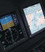
The 296 that I have offers three modes - north up, track up, and course up - but course up is only offered when running in aviation mode, not when running in automotive mode. Maybe sometime we'll get course up as an option on the automotive GPSR's. That's how all large aircraft EFIS systems (like the ones in the little picture of me to the left) present information, so it's what I am most comfortable with. But until then, like Chasr and Jon said, North Up is the easiest to work with. It's much easier to maintain your spatial orientation if the map display stays more or less the same all the time, and the only thing that changes is the orientation of the vehicle symbol.

PanEuropean
 
One for Pan Euro.

My Nav 2 says it has two ports, a USB and a Infrared, question, is the infrared capable of communicating via IR with my pc. I have IR transmitter somewhere but have never tried it and there doesnt appear to be any options in Mapsource to utilise it.
 
Infrared?

Gazza:

That was exactly the first question I asked when I got my SP 2650 last summer. Sadly, the answer is no, because the GPSR can only receive infrared signals, it can't transmit. In order to communicate with anything, it has to be able to transmit as well, if only to transmit a message that says "OK, I'm ready to listen".

Sorry about that, it's a hardware limitation.

PanEuropean
 
Re: Infrared?

PanEuropean said:
Gazza:

That was exactly the first question I asked when I got my SP 2650 last summer. Sadly, the answer is no, because the GPSR can only receive infrared signals, it can't transmit. In order to communicate with anything, it has to be able to transmit as well, if only to transmit a message that says "OK, I'm ready to listen".

Sorry about that, it's a hardware limitation.

PanEuropean

Thanks for the answer. I suspected as much.
 
Track up

I prefer having the track up as I feel I have better spatial awareness! Ie if it's on the left of the track I look to the left. I have to agree that on the 2610 I have, it's much easier on the eye than the SP3 was a year ago.

Also when using the GPSR to "predict" what is going to happen with bends then having track up doesn't fry my brain. BTW I don't use it to blindly like a radar as it can't see what is on the road around the corner! But it does allow some pre-planning eg overtakes.
 
Track Up

Like John it gets my vote, always used it in Track Up. North Up helps when in remote places with crap mapping at least it then helps with dead reckoning and a general feeling of at least which direction you are heading.
 
It's very much a personal preference, no-one can say that one way is better than another. It's also dependent on what previous background the user has working with paper maps. Hikers and surveyors usually rotate paper maps so they view them track up. Motorists commonly use paper maps in north up view.

I think, personally, that it is easier for brand new users (meaning, first day users of GPSR's) to start with North up. Obviously Garmin doesn't agree with me, because the default setting is Track up.

PanEuropean
 
PanEuropean said:
It's very much a personal preference, no-one can say that one way is better than another. It's also dependent on what previous background the user has working with paper maps. Hikers and surveyors usually rotate paper maps so they view them track up. Motorists commonly use paper maps in north up view.

I think, personally, that it is easier for brand new users (meaning, first day users of GPSR's) to start with North up. Obviously Garmin doesn't agree with me, because the default setting is Track up.

PanEuropean

Totaly agree, I have done a lot of map reading in my time and I nearly always rotate the map to the terrain. Also maybe someone can confirm my feelings that the newer GPS have a faster screen refresh which therefore means using track up is OK. I certainly don't have to wait long for mine to refresh...
 
A nice feature of the 2610 is that you can set North Up or Track Up with a touch of the top left corner of the screen.
 
Good point, Bill.

That's one of the many things I like about the touchscreen feature of the SP 26xx series - you can get things done a heck of a lot faster and easier with the touchscreen than you can with pushbuttons.

The trend lately in user interfaces for aviation navigation systems - meaning, the $100,000 plus avionics suites installed in the high-end "heavy iron" corporate aircraft - has been to put control buttons along the side of the screen which have different functions depending on what's displayed on the screen. In other words, the labels identifying what the buttons do are displayed on the screen, and change dynamically as the user switches screen views or switches modes.

Considering the past creativity and history of innovation from the software and hardware engineers at Garmin, I would not be at all surprised if we see this type of user interface in the next generation of consumer GPS products. The only difference will be that Garmin will knock about three zeros off the end of the price, just as they have done with their aviation panel mount systems.

PanEuropean

The picture below shows a $100,000 aircraft navigation display - bet you a coffee that within a year or two, our moto GPSR's will have similar features.
 

Attachments

  • efis.jpg
    efis.jpg
    67 KB · Views: 64


Back
Top Bottom