Here We Go...The North Coast
All I can say is that this is a good run on the bike…with plenty to see if you want to take the time….
if you can make you way to Larne and take the A2 coast road north towards Portrush.
The route from Larne to Magilligan point should take about 2 hours... about 4-5 if you stop for a bite to eat and do a good bit of looking about.
The views and roads are quite stunning but it is a coastal route so in the winter it can be very cold and bleak.
You go through some small villages on this scenic coastal route. head up through Glenarm and Carnlough
and on round Garron Point towards Cushendall, just take in the views, there is not much to stop for on this part of the coast.
Apart from the scenery of course.
You could if you want stop in Cushendall for something to eat, but I would travel on towards Ballycastle,
and maybe have something there.
1/
cushendall
You will have passed through this on your way The Red Arch
You now have a choice to make… where I have placed point A on the map you can go two different routes,
the inland A2 or more of a coastal route towards Torr Head via Cushendun.
Cushendun harbour
On round the coast road to about halfway between Cushendun & Torr Head you pass Coolranny viewing point
from where you can see Scotland
")
From Torr Head you also get a good view of Scotland.
From the disused coastguard station on the top of Torr Head
Looking back in the Cushendun direction you see this..
And looking the other way you see Fair Head and Rathlin Island
This one is looking back towards Torr Head
The road from Torr head till you reach Hunters Bar is great.. steep and twisty with plenty of undulations,
you can turn off the road and head to Murlough Bay as well... it's very picturesque.
These are the veiws at the top before you head down into Murlough Bay
And further down into the bay
You may be lucky like me and meet this little fellow
The coastal road is quite hilly, and in the middle of the winter time not recommended if there is ice or snow,
also further on round passed Torr Head you may find the odd straying sheep….
Free sex for some!!!!.
If you had taken the A2 inland route instead you would have found Loughareema the Vanishing Lake.
Now you see it.....
This mountain route is good if you want a very fast blast on the bike.
At point B on the map where both roads meet there's Hunters Bar on a good Saturday or Sunday.
You may find bikers stopping for a quick bite or drink…you can sit outside on the tables and chairs...
watching the bikes take the S bend that the bar sits on.
Ballycastle is another couple of miles down the road…
it's your biggest town so far and as such has more to offer in the way of food, drink, music, etc.
Bikes gather at the Harbour and ruff tuff bikers go get themselves ice cream from one of the many purveyors of the frozen pleasures around there.
The harbour has a ferry that goes to Rathlin Island...only on foot no motorbikes or cars
There was a Ferry that went to Cambletown in Scotland but it was not economic so since has stopped running.
Ballycastle has on the last Monday and Tuesday of august The Lammas Fair.
The whole town is at a stand still the main street turns into one big market full of stalls...
selling any old tat and sticky yellow stuff called Yellowman.
Live Music
The road from Ballycastle to Portrush is great for the bike...
the sad thing is that there is so much you could see along this route you'll not get a good go at the road itself.
Carrick-a-Rede Rope Bridge would be your next place to stop but there is
remains of Kenbane (meaning: White Head) Castle on the way to Carrick-a-Rede.
Not really the biggest castle in the world…but it is there.
Here it is in it's full glory
On the path down to Kenbane you have this view to the right with caves at sea level.
And an artistic Shot of Kenbane
The rope bridge is not for the faint hearted... worth doing but it takes a little time to walk down to it.
You get to see Sheep Island on the way down to the Rope bridge
Cick for a panoramic view of Carick_A-Rede from opposite sheep Island
Have a cuppa to settle the nerves.
The Rope Bridge Tea Rooms
Next is Ballintoy...a one street village basically it has a Hostel, Pubs and places to eat the Fullerton Arms in the village has B&B.
The harbour is just outside the village it has a shop for tea and Ice cream.
Cick for a panoramic view of Ballintoy Harbour
This is a view over the top of the harbour and Sheep Island with Rathlin beyond (you can't see the Harbour in the pic)
Whitepark Bay Youth Hostel is nearby.
Whitepark Bay and Port Bradden are next
From Whitepark Bay viewing point to the right you can see part of Rathlin still
And to the left you see the rest of Whitepark Bay with Port Braddon within it and The Giant's Causeway in the background.
Port Braddon with the smallest church in Ireland
Now for one that most of you will know of... The Giant's Causeway
The Giant’s Causeway info
A Visual Tour Of the Causeway
A must see if you've never been there before.
The Giants Causeway official guide
If you're looking for somewhere to stay near the Giants Causeway and Bushmills I can recommend Ballylinny self catering cottages…
really close to the Giants Causeways entrance and just outside Bushmills itself,
the only catch is that you have to stay for two days at least.
Ballylinny cottages
In Bushmills itself you can stay in
The Bushmills Inn hotel
You may want to check out the Bushmills Distillery now you have got this far.
Tour times are….
April - October (last tour 4pm each day)
• Monday to Saturday 9.30am - 5.30pm
• Sunday 12 noon - 5.30pm
November - March
• Monday to Friday 5 tours daily (10.30am, 11.30am, 1.30pm, 2.30pm, & 3.30pm)
• Saturday and Sunday 3 tours daily (1.30pm, 2.30pm & 3.30pm)
They are closed on Good Friday, July 12th, Christmas & New Years holidays. For groups please telephone to arrange your visit: +44 (0)28 207 33218. There is an admission charge.
Check out the website
Bushmills Distillery
After that you head on round the coast to Dunluce Castle…if you think you've seen it before and you're a Led Zeppelin fan…then you have...
it's on the inside of one of there albums. Houses of the Holy I think.
Opening Times
April - Sept: Mon - Sat 10am to 6pm Sun 2 - 6pm
July & August Sundays 12 - 6pm
Oct - March: Tues - Sat 10am to 4pm Sun 2pm to 4pm
Admittance : Adults £1.50p
Concession : £0.75p Groups(+10): £ 0.75p
Contact: Telephone 028 207 31938
Then you head past The White Rocks
(the road down to the White Rocks connects you to East Strand beach which goes the whole way into Portrush...
that's if you need a long walk
)
The White Rocks is also a great place to have a BBQ at night

,watching the Sunset
You also look out over The Skerries and Royal Portrush Golf Club.
After that you can head into Portrush or on round to Portstewart two seaside towns. Portrush has the biggest nightclub in Ireland
LUSH
Or for the older ones head down to the harbour area.
The Harbour
In Portstewart is a bit smaller as far as living it up goes…but I would go out a night in Portstewart before I would go to Portrush….
more tourist type people in Portrush.
The Anchor and Bar 7 are the two places in Portstewart where most people would go out to. Both serve good food.
And have bands playing...with small nightclubs up stairs.
The Anchor
Plenty of caravan sites around if you're looking to camp.
The place is at its best in may when the North West 200 is on…I can't recommend it highly enough.
If you are into bikes and racing a great atmosphere for the event and the week leading up to it.
you can get access to all the riders by getting a pit pass for about £10.
The 2007 International Northwest 200 date has not been confirmed. Usually the second weekend in May.
crap looking site but it tells all about the NW200
Most of the riders drink in the York or the Anchor so you can get to meet all the big ones
some pics of this years
Next recommended stop would be Castlerock…you have to drive through Coleraine to get to it.
There is nothing worth stopping for in Coleraine unless you want to go shopping.
On the other hand you could take a detour to Ballymoney to see some boy standing by a bike.
After you get back on track from Joey's start heading to Castlerock again.
Not much point in driving down into Castlerock itself, drive past the turn on the right that takes you into Castlerock...
head on about another mile and you'll come to the lions gates the entrance to Downhill Castle and the Mussenden Temple.
Modelled on the temples of Vesta at Rome and Tivoli,
the elegant domed structure was built in 1783 as a "summer library" by the eccentric Frederick Augustus Hervey.
He was Anglican Bishop of Derry and 4th Earl of Bristol.
An unorthodox cleric, he once organised a curates' race along the sands at Downhill, the winners being rewarded with benefices in his diocese.
He was also unconventional for his time in his tolerance of Catholics,
permitting a weekly Mass in the Temple since there was no local Catholic church.
WC available when Temple open (situated at Lion’s Gate car park)
Opening arrangements:
Temple
12 Mar–20 Mar 11–6 Sa Su
25 Mar–1 Apr 11–6 Mo Tu We Th Fr Sa Su
2 Apr–29 May 11–6 Sa Su
1 Jun–30 Jun 11–6 Mo Tu We Th Fr Sa Su
1 Jul–31 Aug 11–7:30 Mo Tu We Th Fr Sa Su
3 Sep–25 Sep 11–6 Sa Su
1 Oct–30 Oct 11–5 Sa Su
Grounds
All year Dawn-dusk Mo Tu We Th Fr Sa Su
Notes: Open Good Fri. Open BH Mons.
Admission prices:
Grounds & Temple – Motorbike: £2.30. Car: £3.70. Minibus: £7.40. Charges apply when Temple open.
Downhill, Mussenden Temple info
after that you travel on about half a mile down into Downhill its self at this point you have another choice go sharp left and up The Bishops road.....
About 2 miles later you are 850ft higher and at Gortmore Viewing Point, from this you have some breathtaking views.
Panaramic view from the viewing point
Or drive straight on toward Magilligan point and get the ferry to Greencastle...
and take a look at the Martello Tower while you wait for the next sailing...
it's only about 200 yards past the ferry terminal
Lough Foyle Ferry takes 15 mins
and you're in Donegal.
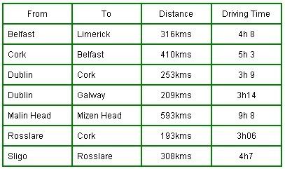
Here's a map of the Inishowen Peninsula near where the ferry lands
Landing at Greencastle
If you head to the right when you get off the Ferry you can make your way to the Inishowen Lighthouse.
After the lighthouse if you keep to the right about half a mile you'll get to a viewing point
(i see a bit of target practice has been going on
)
Yet again with good views on the way to the viewing point
If you see the other sign at the viewing point it says "Road not suitable for cars"
an invitation as if one was needed to head on up that road on the GS

Nice GS roads
this track is not on the map I posted
Further up the road turns to track and although passable it wouldn't be recommended if you're on your own
this route takes you back down to the main road... if you can get through it
Some info on
The Inishowen Peninsula
Kinnagoe bay is next on the way round the coast.... it is quite stunning if you choose to go that way
If you head more inland you can take in some more stunning views from up at the TV transmitter
A look back at NI from the TV tramsmitter you can see where the ferry docks on the right side of the Peninsula
And a look again from NI at Donegal
You also have the option of going through Limavady and on to Derry/Londonderry by road.
<iframe frameborder="1" height="800" scrolling="auto" src="http://www.ramelton.net/trips.htm" width="880"></iframe></font></p>


 l
l

