A clockwise loop around northern Spain into Portugal, returning via Santander

For Zaragossa to Teruel I can't recommend any of the route north of Calanda but can recommend the following ...


The road down through Zorita del Maestrazgo is a beaut and the Santuario de la Balma offers a really nice break which includes nice views of the road below. The road from Cantavieja to Teruel is nice but not really a great road - there are many better options nearby if inclined. I've recently rode from Morella to La Iglesuela via Cinctorres and really enjoyed it (there's a great Mirador not far out of Iglesuela).

If they can afford it I would highly recommend a day (or possibly 2 days) based in Cantavieja (or nearby) to tour the Maestrazgo region - an absolute beast of a motorcyclibg region. Here's a psooble day loop if possible. There are many more roads in the area and you could easily exopand into 2 day loops with add-ons.


I heard Simon and others say that Teruel is a nice town to base but I chose Mora de Rubuelos as I prefer the smaller locations.

Is this to granular?

Thank you.

I’ll do some work around these suggestions.

Thank you everyone else too, I’ll read through all the suggestions and comments. When I get back home on my multi-monitor big screen Mac and with some paper maps, I can start to drag my opening scribbled out route a bit easier. I can also start to subdivide any alternatives into days, having in mind the time periods my friend has in mind. It’s all very much a work in progress. I haven’t even started to look at my Michelin Green Guide or Rough Guide to……
 
Last edited:
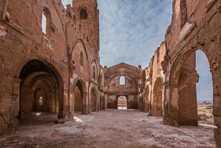
Perhaps after Zaragoza call in at Belchite, a small diversion. The town was severely damaged in the civil war and was preserved as a monument….

I have dropped that in. If we stay in Zaragoza, it’s not too far away at all.

IMG_4299.jpg
 
For Zaragossa to Teruel I can't recommend any of the route north of Calanda but can recommend the following ...

Thank you.

I have managed to alter the original route around, just by playing about on my iPad and MyRoute.

IMG_4300.jpg
IMG_4302.jpeg
 
Last edited:
Rather than wait for a return to home and giant Mac screens, I roughed out another route, incorporating some of the alterations kindly recommended by people in the thread. It is amazing what just a little patience in MyRoute on an iPad can do.


Now it’s 1,700 miles, so only 100 miles less. The largest change was from dragging the route away from the northern coast of Spain.

Take no notice of the hotels. These may well change (or have to change) in order to refit some days.

News and views welcome. For example, I noted this suggestion:

Perhaps stay a little to the north in Lugo, surrounded by massive Roman walls which you can walk and circumnavigate the old town.

Which I haven’t done anything about yet.

 
Last edited:
Between 38 -39 I would divert slightly to the south and the Serra da Estrela Nature Park. Go for altitude. Great roads, scenery, the best I have found in Portugal.…..

I have updated the hashed out route, to include this suggestion:

IMG_4303.jpg

 
I have amended the opening end of the route, to miss out Pamplona and coming into Zaragoza on a more north / south axis, rather than bending out to the west. This brings in the Col d‘Erroymendi, between Larau (well known) and Ezcároz

IMG_4305.jpg

 
Hopefully, this thread (with all the contributions made from third parties) shows:

a. How things evolve and change.

b. How many (or how few) ways there are to go from A to B, on a route of 1,800 miles.

c. How it’s now possible to create long routes, using no paper maps, utilising nothing more than a web-based app (MyRoute) and an iPad, enjoying the app’s ability to display a mixture of maps, including the popular Michelin maps in multiple scales and levels of detail.

d. How it becomes easier for everyone if a roughed out (but reasonably clear) route is displayed to start with, so that everyone can see what the opening poster has in mind.

e. How, when suggesting changes, people give some reasonably clear instructions as to the alternative route(s) and ideas they are putting forward and why.

f. How difficult it would be for anyone to answer the typical question: “Me and my five mates, want to do Spain, no motorways, twisties, with hotels and stuff” without telling anyone too much more.

A bit of effort put in at the start and along the way, goes a long way.
 
Last edited:
My friend is now having second thoughts about the full clockwise circle, combined with Ld Mans.

I have suggested that the western half might be more ‘interesting’ than the eastern portion. It would sort of make sense, as it would give him fewer ‘A to B to C and then stop for two nights’. He could also ride more of the large nature parks, rather than ride through them and / or have more than one or two nights in some places. 21 days is still on the cards, for the combined Le Mans / Spain jaunt.

Something like this, perhaps:

IMG_4307.jpeg
 
the area to the west of your near vertical green arrow is excellent - Ponferrada would be a good overnight stop and the AS12 that runs along the River Navia to the port of Navia is a cracker. Navia itself is a pleasant town with a working port, and the hotel Palacio Arias was pretty good https://goo.gl/maps/JLX4F4Sq5UFfhKfG7
I'm going back to this area next month after staying in Navia in 2018.
 
Here’s a first stab roughed out alternative, based on a (broadly) circular route, taking in the hints from Wessie, starting and ending in Santander. I started and stopped the route there, simply as a point on the map. That being said, it’s a popular location for people to arrive at and / or depart from. My friend also wants to come back from Santander, so it had to go in anyway. Joining the route from France will require some changes, but they are easy to make.


Excluding the addition of a stretch from Le Mans and the schlep over the Pyrenees, it’s roughly 1,500 miles long, which works. The return stretch up the middle, uses some pretty ‘rugged‘ roads (very similar to the wilder bits of the Cevennes in France, which I like) but Google’s excellent Streetview tells you what to expect. It’s all quite rideable on any off-the-shelf conventional motorcycle or drivable in a normal family car.
 
your next homework is to research about the Knight's Templar in Ponferrada.

I'm staying in the Hotel Ponferrada Plaza next month so will let you know what it's like. There is a Templar themed hotel but it had no capacity for my dates.
 
Thank you, again.

I have seen and visited several of the old Templar castles in France, but none (as I can recall) in any detail in Spain.

The name, Jacques de Molly, I half recognised from reading this book, a few years ago:

IMG_4311.jpeg

I hadn’t though, until your prompt, linked the route, him and the castle up. It can and will, definitely go on the list of ‘must do’.
 
I knew that would pique your interest.

There's some Roman history in the area as well due to local minerals - apparently they used to blow up the hills to get access using hydraulics.

man made landscape
800px-Panor%C3%A1mica_de_Las_M%C3%A9dulas.jpg


Very similar to the red rocks in Roussillon, Provence, also Roman in origin. Ochre for dye, was what they wanted.
 
Looks good Wapping. I have a few suggestions.
Perhaps after Zaragoza call in at Belchite, a small diversion. The town was severely damaged in the civil war and was preserved as a monument.
Between 38 -39 I would divert slightly to the south and the Serra da Estrela Nature Park. Go for altitude. Great roads, scenery, the best I have found in Portugal.
Your route does not take in Lisbon, which you mention. (A pretty hairy place to ride a motorcycle, not something I will repeat).
The over night at 70. Perhaps stay a little to the north in Lugo, surrounded by massive Roman walls which you can walk and circumnavigate the old town.
I would ride the north of Spain a little more into the high mountains away from the coast for the better roads?
Enjoy.
Access to the Belchite site is by guided tours only and you may have to book ...
 
Here’s a first stab roughed out alternative, based on a (broadly) circular route, taking in the hints from Wessie, starting and ending in Santander. I started and stopped the route there, simply as a point on the map. That being said, it’s a popular location for people to arrive at and / or depart from. My friend also wants to come back from Santander, so it had to go in anyway. Joining the route from France will require some changes, but they are easy to make.


Excluding the addition of a stretch from Le Mans and the schlep over the Pyrenees, it’s roughly 1,500 miles long, which works. The return stretch up the middle, uses some pretty ‘rugged‘ roads (very similar to the wilder bits of the Cevennes in France, which I like) but Google’s excellent Streetview tells you what to expect. It’s all quite rideable on any off-the-shelf conventional motorcycle or drivable in a normal family car.
I shall soon be departing these shores so this was of interest. I saved your MyRoute App as a GPX 1.2, imported into Basecamp and it gave me a route and a track. So far so good. However the route is unediitable as the only waypoints are start and finish and no shaping points so I could alter the route.

Is this just the way it is and one has to redraw over the track with a new route to achieve the desired result?

Just wondering.
Thanks in advance.
 
Last edited:
I shall soon be departing these shores so this was of interest. I saved your MyRoute App as a GPX 1.2, imported into Basecamp and it gave me a route and a track. So far so good. However the route is unediitable as the only waypoints are start and finish and no shaping points so I could alter the route.

Is this just the way it is and one has to redraw over the track with a new route to achieve the desired result?

Just wondering.
Thanks in advance.

Are you trying to edit (amend) it in MyRoute or BaseCamp, please?

Are you sure you are trying to edit (amend) the route and not a track?
 
Are you trying to edit (amend) it in MyRoute or BaseCamp, please?

Are you sure you are trying to edit (amend) the route and not a track?
Edit in Basecamp.

I tried editing the ‘route’ in Basecamp by simply trying to redirect part of the route to a different town. That was the ambition. Clicking insert point highlights the first waypoint only and then if I insert the new shaping point at my new town it creates a recalculated route between the two way points discarding the rest of your multi-day route. Not what I wanted.

As a ‘track’ there are a gazillion shaping points, so that would be hard work to manipulate.

Thanks
 
Last edited:
OK

1. In BaseCamp, it might be easiest just to trace over the route, making any amendments as you go.

2. Yiu should be able to amend the route quite easily in MyRoute. I have certainly made several versions, since sharing this one.

Make a copy and play about. You can’t break it.


Back
Top Bottom