Excellent, Hoff's problem resolved.
Back to Peter's post #15
(A) 20 active routes displayed on the screen should be enough for most bods' purposes. Have in mind that 20 routes represents probably 20 days' of travel and that each route might be up to 350 miles (or longer) in length; that's 7,000 miles (or futher). You are certainly not going to ride them all in one day, so why have more than 20 displayed as available?
(B) The device needs to recalculate on import for perhaps two or more reasons:
(1) It was - perhaps - created on a different mapset or is now being used on a device with different preference setttings. This is not true in your case as your settings and maps are identical.
(2) More importantly, the device can only display certain file types. Garmin exports a .gpx file extension or summat like that. The device may not be able to read the file extension, so it will need to convert. The conversion may be called 'recalculation', perhaps? If you share a route on the latest Nav V via Bluetooth from one device to another, the importation is all but instant, 'conversion' / 'recalculation' having been largely undertaken by the donor device already.
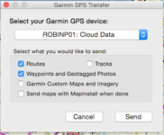
(C) If you want to load reserve routes onto a spare card - as suggested by Garmin - it's easy. If you want their associated maps, it's easy too. Simply export the routes, along with their map tiles. You are going to Spain, so you'll not need maps of downtown Helsinki or the darker alleys of Sorento, too.... unless you are very lost!!

(D) You can check if your device / card brings up the 'invisible' routes as you delete others. Create say 35 routes, where they go matters not. Your device sould display 20 and hold 10 more on the card, rendering 5 perhaps invisible. Delete say 10 of the displayed rooutes and import 5 fresh ones from the card. Do the 5 'invisible'ones now appear? In fact, thinking about it.... Why bother creating 35 trial routes at all? Your 20 plus routes for Spain are all on the device / card.... or they should be. Delete routes (making sure you have backed up the device first) and see what happens. At least you'll know before you hit the plains of Spain at 42 C

One last tip. For a very long trip I would be very tempted to buy a secondhand device as a back-up. You can always sell it afterwards, maybe even making a couple of quid on the way through. You are away a long time; break / lose your device or have it go belly-up would not be great fun, especially as you've spent hours creating routes.


 No idea what Mapinstall is!