Blocked public footpath

Barnoe

Well-known member
UKGSer Subscriber
Joined
Aug 9, 2020
Messages
5,208
Reaction score
5,790
Location
Milnrow, Rochdale
So i was hiking at weekend following a footpath and got to the end of a field were a stile should have been?
high fence, anti climb paint and barbed wire.

Ummm

So i climbed the side fence onto the motorway embankment walked past the blockage and climbed back over.
Further down the same field a gate with chain and big padlock
So i check GPS... yep i am on the track?

So it looks like some farmer who is pissed off with folk walking through his land has decided to block everyone.

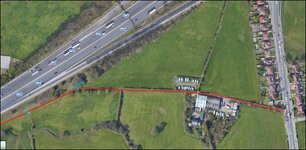
This is the section

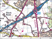
Map ref: SD860085
What 3 Words: pads.valve.shade

RED is the path i followed,
BLUE is me climbing over the fence then later the gate.

Would you report it?
1790086015859.jpg
 

Attachments

  • 1790086282953.jpg
    1790086282953.jpg
    281.5 KB · Views: 3
So i was hiking at weekend following a footpath and got to the end of a field were a stile should have been?
high fence, anti climb paint and barbed wire.

Ummm

So i climbed the side fence onto the motorway embankment walked past the blockage and climbed back over.
Further down the same field a gate with chain and big padlock
So i check GPS... yep i am on the track?

So it looks like some farmer who is pissed off with folk walking through his land has decided to block everyone.

This is the section
MEDIA=googlemaps2]!1m14!1m12!1m3!1d2819.5036032876287!2d-2.20975581495354!3d53.57341463330265!2m3!1f0!2f0!3f0!3m2!1i1024!2i768!4f13.1!5e1!3m2!1sen!2suk!4v1790085750373!5m2!1sen!2suk[/MEDIA]

Map ref: SD860085
What 3 Words: pads.valve.shade

RED is the path i followed,
BLUE is me climbing over the fence then later the gate.

Would you report it?
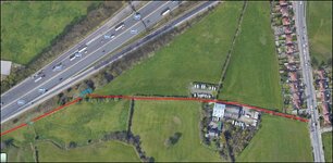
View attachment 540840
To who ?
 
I reported a blocked footpath last year to the council bod responsible for footpaths. Contact was on their website and it was the same rights of way team that our TRF group liaises with on a regular basis.

Farmer had allowed crops to grow all over it making it impossible to walk along.

Council bod contacted Landowner, who then rectified situation within a couple of days and never had an issue since.
 
So i was hiking at weekend following a footpath and got to the end of a field were a stile should have been?
high fence, anti climb paint and barbed wire.

Ummm

So i climbed the side fence onto the motorway embankment walked past the blockage and climbed back over.
Further down the same field a gate with chain and big padlock
So i check GPS... yep i am on the track?

So it looks like some farmer who is pissed off with folk walking through his land has decided to block everyone.

This is the section

Map ref: SD860085
What 3 Words: pads.valve.shade

RED is the path i followed,
BLUE is me climbing over the fence then later the gate.

Would you report it?

View attachment 540840
Have you checked it is still a footpath?
 
I reported a blocked footpath last year to the council bod responsible for footpaths. Contact was on their website and it was the same rights of way team that our TRF group liaises with on a regular basis.

Farmer had allowed crops to grow all over it making it impossible to walk along.

Council bod contacted Landowner, who then rectified situation within a couple of days and never had an issue since.
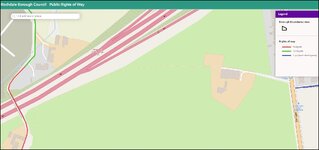
Its the "Rochdale Way" trail that is maintained by Rochdale council.
Their very own and only official footpath.

think i will fling an email over and see what happens
 
So on the Long Distance Walkers Association website
it says this

UPDATE July 2022: A reported obstruction of this part of the Rochdale Way near Oakridge Farm, south of junction 19 of the M62, grid reference SD 861 085.

I might take a walk this weekend with a hand saw and lump hammer.
 
Around my way... there are many footpaths that are either blocked, or due to rampant house building, simply don't exist at all. I'm led to believe that the council are supposed to officially re-route and send details to Ordnance Survey for map updating... but it either doesn't happen, or the delay is measured in years. So anywhere with houses built in the last (say) 5 years (which is almost everywhere now), is a lottery in the footpath department.
 
Around my way... there are many footpaths that are either blocked, or due to rampant house building, simply don't exist at all. I'm led to believe that the council are supposed to officially re-route and send details to Ordnance Survey for map updating... but it either doesn't happen, or the delay is measured in years. So anywhere with houses built in the last (say) 5 years (which is almost everywhere now), is a lottery in the footpath department.
Where there have been new housing developments near me, the existing footpaths/right of ways have been redefined and altered around those developments.
 
On the rare occasion I have reported greenlaned blockages the Council responded quickly and even removed the blockage themselves. It might also be worth trying to find an online copy of the Councils Definitive Map.
 
Its been a week since i email the council, I've heard nothing.
Since this has been blocked 4 years now i don't have much confidence anything will be done.
 
Its been a week since i email the council, I've heard nothing.
Since this has been blocked 4 years now i don't have much confidence anything will be done.
I found I got the best results when I was a pain in the arse to the person responsible within the Council. It was many years ago and I would think they have all retired/left/died by now but at the time I had direct numbers for the head of RoW, the office for Byways and also the engineer responsible for highway maintenance. No doubt the Council cut backs would make it more difficult today and an email could be at the back of the queue in Mr Nobody's 'to do' tray.
 
I thought the farmers just put a bull in the field the pathway was on if they wanted to stop people’s right of way .


Back
Top Bottom