EIRE. POOR COVERAGE

Taff

Well-known member
UKGSer Subscriber
Joined
Feb 21, 2004
Messages
7,351
Reaction score
6
Location
South West Wales
There's a group of us going across to Eire in June, but I notice that the coverage is very poor - in fact so bad that it's almost pointless taking the GPS, I use City Navigator - Version 6. :(

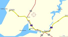
I've read before that the coverage is bad, but you'd expect a fair sized town like Lahinch to be shown on the map. I'm sure that I've read somewhere that "Worldmap" offers far better coverage. Is this true?

Any other suggestions would be appreciated, but before someone suggests I take a map - I will. ;)
 
Eire Coverage

Yep - the covearge outside the cities is not great ( read - Sh**e)- I have a 2610 - with whatever software it comes with as standard. BUT its good in the cities and overall you will see the other N routes marked and at least you will be able to find your way back to them when ( not if ) you get lost.
I am lead to beleive that other software can be loaded and you will have proper OS maps - I guess you ll get a proper reply as regards this - and I ll be interested myself as to waht one should do.
Bring it - its still usefull and worth the extra weight.......
Have a good trip .....
 
This was the best effort City Navigator could do for me last year when we went. I stuck Lahinch in as a waypoint using Microsoft Autoroute as a guide.
 

Attachments

  • screenshot024.jpg
    screenshot024.jpg
    31.6 KB · Views: 131
This is as good as it gets, however later versions of Worldmap may give a better detail. My version is a few years old now.
 

Attachments

  • screenshot002.jpg
    screenshot002.jpg
    40.7 KB · Views: 127
There are only 2 versions of WorldMap.

My understanding is that the mapping is the same but they repackaged it with a later version of the MapSource program.
 
I loaded both Euro City Nav and Worldmap into my gps. Used Euro City Nav and autorouting until it couldn't route anymore then switched mapping to Worldmap and followed the roads to Ennistymon and it was sign posted from there. Didn't even use my map. Still took it cos its good for overviews and gps's are lectric and sometimes go sick.
 
Think I'll leave it at home - one less thing to worry about. Until it's time for a meal and a pint, this crowd (not GS'ers) don't want to go into the cities - they would rather have a good blat on the country roads. Looks like the map holder was a timely purchase then. :P
 
Use 2001 version of Autoroute

If you use the 2001 version of Autoroute, you can get more detail of the minor roads. The 2004 version of Autoroute has excluded much of the detail of the Irish maps, with roads and villages removed and seaports located inland.
 
Use a map! Think of the self satisfaction of brushing up your map reading skills! I use an AA 1:300,000 map for general navigation and os discovery series 1:50,000 for detailed stuff in a particular area. Do yourself a nice road list with the turns indicated by arrows. Stick it to the tank and you'll not get lost!.............much:D


Back
Top Bottom