First stage of DeGarminification

I am probably being very thick, but is it the DMB Hub app have you loaded onto a phone? If so, is it only Android at the moment?

Thanks.
No such thing as a silly question!

DMD (now DMD2) is an Android app that you can load on any Android phone or tablet. There are free and paid versions.

However, I have bought the DMD Nor7e, which is an Android device made specifically for motorcycles, and it comes with the DMD app pre installed.

It’s really a dedicated motorcycle sat nav, with proper charging and bike mounts, which has the convenience of being able to run other apps because it uses the Android OS.
 
I am probably being very thick, but is it the DMB Hub app have you loaded onto a phone? If so, is it only Android at the moment?

Thanks.
Sorry, I misread your question, but bdev answered it.

I haven’t investigated the IOS app either, but I will once I’ve got to grips with the device and Android.

I have to say so far it’s very impressive.

Today I found a group ride feature, which allows you to track all riders in your group. If a rider has an issue they can issue a help alert to the other riders, which could prevent a group all riding on while someone has a puncture for example.
 
Sorry, I misread your question, but bdev answered it.

I haven’t investigated the IOS app either, but I will once I’ve got to grips with the device and Android.

I have to say so far it’s very impressive.

Today I found a group ride feature, which allows you to track all riders in your group. If a rider has an issue they can issue a help alert to the other riders, which could prevent a group all riding on while someone has a puncture for example.

We used the group ride feature last weekend in Wales for the first time.... it's brilliant ! - allows everyone in the group to have the same GPX shared automatically and for you to see the position of the other group members.

Very impressed with the new DMD2 version (been using the old version for a while)
 
So this will keep Treb happy. There's a very nice planning tool on the device. Using the tool, either a route or a track can be made, with sections so for example it cold include a road ride to a trail, then a track on a byway, then a road ride to the pub.

Locations can be searched, added from a POI, or from a favourite (your own POI's, in effect), or a GPX file can be imported and modified. Tracks and routes can be split and joined, on the device itself. Useful

If you've imported a gpu, What's a gpu Berin?

Used together with the Hub app, I think this makes Basecamp redundant. Not in my lifetime Berin :D
Out of curiosity, how many Custom POIs' can your gizmo handle?
And as for the group ride feature...Nein Danke!
 
Out of curiosity, how many Custom POIs' can your gizmo handle?
And as for the group ride feature...Nein Danke!
I've been looking at this. Currently I run defence heritage Custom POI's for NI, Dolmen Tombs and public loos/picnic areas for Ireland/NI on my Zumo XT and CWGC sites for the whole of europe. On the XT these can be made visible or not. But can contain lots of text if you highlight a POI that you might want to visit. I'm not sure if there is a limit on Basecamp/the XT but the CWGC data is ~25,000 sites and it was no issue. I've imported ~5000 defence heritage sites into the DMD hub and that was not an issue and it retains the descriptive text of the original files and you can set a proximity warning for these. If I'm just riding around and I have the time I would visit these sites hence my preference to have them loaded. (in MRA the text is limited and the file size has to be less than 10,000 data points) . I'm not sure how to get these to display on the app yet. If it is possible it makes DMD a complete replacement for the XT from the software perspective as it duplicates POI loader used in connection with Basecamp.
 
I'm still playing trying to find the buffer but at some 358 thousand custom pois' so far so good!
and before anyone pipes out- no. I am not going to visit all of them!
 
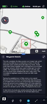
I was able to display a route free GPX file on the map in the app and when you touch the Waypoint/poi you get the accompanying information. I managed to bulk change the indicator icons when I first imported the file. But I started again and can't remember how to do it now:blast

1790941355785.jpg

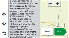
Similar information from the site as displayed on a Garmin Zumo XT...you scroll the information.

1790941486142.jpg
 
@Mzokk
In BC - and there may be some resemblance - find your list of waypoints - highlight one- right click and hold and scroll to the end of those you wish to change- then open.
You can change the icon there, add info which will be duplicated in all the chosen waypoints and :blagblah
If of no use- disregard!
 
@Mzokk
In BC - and there may be some resemblance - find your list of waypoints - highlight one- right click and hold and scroll to the end of those you wish to change- then open.
You can change the icon there, add info which will be duplicated in all the chosen waypoints and :blagblah
If of no use- disregard!
I had the waypoints in a GPX file and think I picked the custom waypoint on import. There are a load to choose from and I picked a little tank :D I could not get it to show in the app so deleted the project and started again and got it to show on the map but with the default waypoint symbol. I think I need to study some video's and documentation to get the hang of it.

In Basecamp I use POI loader and in it you can use any Icon (including those you make yourself) that is not more than 24X24 pixels as well as a custom alert noise in WAV format (for public loos my alert makes a fart noise because i'm childish). You just bung these into the same folder as your CSV/GPX file with the waypoints and select them when using poi loader to make your *.gpi file.
 
Out of curiosity, how many Custom POIs' can your gizmo handle?
And as for the group ride feature...Nein Danke!
I don’t know how many poi’s it can handle, but I’ll find out.

Group ride is of not compulsory but for a group out on the trails it could well be very handy. I presume it requires internet, but nonetheless- we had a situation once where a rider was trapped under his 950SE and no one knew.

And basecamp will end of life to all intents and purposes fo Mac users with macOS 28, late next year
 
Just a thought if you use Custom POI icons and assuming they are the right size, bit depth etc

Whatever you have in BC you must have the same in your Garmin unit and any gpx or..csv files you may have for them to become visible and useable.

I have zero idea if it is the same principle in your new gizmo.
And the love affair between BC and Windows will live on. But with Macs...think of it as a mistress who has well passed her sell by date and has got her marching orders!
 
Just a thought if you use Custom POI icons and assuming they are the right size, bit depth etc

Whatever you have in BC you must have the same in your Garmin unit and any gpx or..csv files you may have for them to become visible and useable.

I have zero idea if it is the same principle in your new gizmo.
And the love affair between BC and Windows will live on. But with Macs...think of it as a mistress who has well passed her sell by date and has got her marching orders!
Bc for windows is also no longer supported- it’s just that Microsoft update so infrequently that there are no changes to make it break.
As far as I can see also the newer Garmin models don’t support a connection to basecamp, again no issue if you use an old sat nav.
 
Old :rob is often better!
aka well tested with most 'bugs' ironed out.
(Alegedly!)
 
Consider the 276cX-
like the boxer engine, it's an 'evolution' model- originally a marine unit of which I have had the series- excellent units- fast too- it out performs the 710- which I run side by side and has some options which I have yet to find in other units.
 
I had one. It worked well, apart from the lag was so bad that trail riding I’d ridden past the track I was supposed to take before it caught up. And the buttons were on the wrong side, and it’s the size of a house brick.

I sold it when the Montana 7xx came out, and they were very good and quite advanced for 10 years ago, till Garmin naturally buggered up the software.

I’ve used navigation systems before Ronnie gifted GPS to the world, and pretty much every type of gps since. I’ve stuck with Garmin till now, but the new devices all force you down the explore/tread route, the XT is usable but has its many well documented foibles, and the Montana’s are pretty good but are really now far behind in what they do. That and the imminent demise of BC has led me to to where I am now, which is getting rid of Garmin.

so next post from me will be back topic, which is how well the the DMD device and system copes with what I want to do.


Back
Top Bottom