GPX - M’off - Hurtgen Forest

I know the way onwards fairly well, as much of it is the roads I take when heading to Chimay. This time though, I be turning off before Chimay and heading instead to Dinant, then on to Trois Ponts in the Belgian Ardennes:

Two and a smidge hours until lunch and about five to my hotel, if I don’t stop along the way, don’t take a wrong turn and don’t find a road closed:

IMG_0333.jpg

IMG_0332.jpg
 
Gruesome battle. Americans lost 2 divisions and didn’t manage to take the forest.
Went there 13 years ago with junior and walk the US Army path. 10 km from Hurtgenwald/Vssenack/Schmidt axis. and back a different path. Stayed for 2 days.
The original forest burned down. A group of volunteers still search for mines and there is a small museum in Vossenack.
The battle for the church is a mission in Call of Duty, inspired from fighting in Vossenack. The church is small and is hard to believe that the Germans were holding half and the Americans were holding the other.
In one of the episodes of Band of Brothers they walk through the forest after the Germans retreated. The snow was melting and thousands of bodies were coming to view. After the war POW were used to clear the forest with a promise of faster release. Over 200 German POW died.
Have a good trip.
This documentary with participants who were there is excellent
 

Attachments

  • IMG_6800.jpg
    IMG_6800.jpg
    95.7 KB · Views: 11
  • IMG_6801.jpeg
    IMG_6801.jpeg
    566.6 KB · Views: 13
One of the advantages of riding along on your own, is that you can stop to take a picture whenever you fancy. Likewise, having all day to go 280 mikes from A to B helps.

I have passed this weir umpteen times, in all seasons and weathers. I have never stopped. Today was a chance to right that wrong:

IMG_0335.jpegIMG_0336.jpegIMG_0338.jpeg

It marks the edge of the small town of Maroilles, which gives its name to a popular and very good local cheese:

 
Coming into Soire le Chateau, a very SiFi building looms up, visible from miles away:

IMG_0339.jpegIMG_0340.jpeg

From there, I crossed the Belgium border, going along some farm roads:

IMG_0342.jpegIMG_0343.jpegIMG_0344.jpegIMG_0345.jpeg

Before some tree lined roads and an expensive looking village:

IMG_0346.jpegIMG_0347.jpeg
 
Lunchtime at a popular stop for locals, just past Sosoye. I have stopped here before, making a note of it at the time:

IMG_0349.jpegIMG_0351.jpeg

Then on via Dinant:

IMG_0355.jpegIMG_0357.jpeg

And possibly the world’s most photographed tank; the Panther from December ‘44 at Manhay:

IMG_0360.jpegIMG_0361.jpeg

IMG_0358.jpeg
IMG_0359.jpeg
 
Last edited:
I had planned to stop in Stavelot for a coffee, but I chose to press on instead, with just an hour to go.

I went through Trois Ponts, pausing only to take a snap of the excellent chip shop on the road out of town, heading to Stavelot:

IMG_0363.jpeg

Across the German border at Kuchelscheid:

IMG_0365.jpeg
 
Day three - Into the Hurtgen Forest

Using various sources, I mapped out the assorted sites to see over the next three days:


The museum is only open on Sundays, so that will have to wait.

The website tells me that I have contrived to arrive at the start of roadworks!


IMG_1204.jpeg


And indeed the road is closed. Hey-ho, at least I am not being shelled, mortared, shot at or stepping around mines:

IMG_1205.jpeg

Besides the places I’ve mapped out in MyRoute, I have a whole batch saved in a file in Google maps. This is new to me. It’ll be interesting to see how lost I find myself:

 
Last edited:
A good full day. Lots of sites ticked off, along with a friendly chat with a local, who gave me a couple of useful tips for the future.

More later as essen und drinken are calling.
 
Day three continued…..

Stop one was at the National Socialist Ordensburg Vogelsang.

Built in the early ‘30s, it was designed, not to train military soldiers but ‘political soldiers’ who would (when Germany triumphed and established a thousand year Reich) run the political side of things. It is revolting, full of every artificial Teutonic knight imagery, false history and bizarre mythology.

The Allies, deeply engaged in fighting all around, all but ignored it completely. The Belgian army took it over after the war.

Worth a visit? Yes, definitely, if you want to see what ‘Turned the Nazi Party on’. A couple of tips:

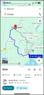
1. I parked in the free car park, used by healthy hikers out rambling. That was a mistake. It is over a mile walk from the entrance barrier to the estate’s buildings. Spend euro 6 on the car park. Luckily, I worked out that there’s a bus which runs every hour from outside the visitor centre to the entrance, which takes four minutes. I came back that way.

2. It’s a big site, on a considerable slope. The sports field and swimming pool are right at the bottom by the lake. It’s a hike down and very long climb up the steps to get back.

3. I used the guide book and leaflet map and still missed some bits. A guided tour would be good.

Motorbikes have a dedicated parking area in the free car park:

IMG_0374.jpeg

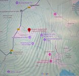
The view across to the avenue (it’s over a mile long) leading to the site’s entry gates:

IMG_0376.jpeg

Next time, I’ll pay tge six euro parking fee:

IMG_0377.jpeg

When the site was taken over by the Belgian army after the war, they built a patrol station. It is one of the very few petrol stations to survive in a 1950’s style, modelled on an American design from the 1920’s. It has a preservation order on it:

IMG_0388.jpeg
The entry area:

IMG_0382.jpeg

The entry area is flanked by ‘towers’:

IMG_0383.jpeg

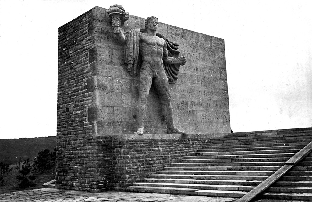
Each with a monumental carving depicting the Nazi ideal of strength and knightly honour:

IMG_0384.jpeg

A second tower inside the complex, apes a castle:

IMG_0390.jpeg

Hopefully, these two shots show how steep the site is. The natural steepness (it is not man made) is repeated throughout the Hurtgen Forest, showing how difficult it was for the Americans to fight their way up the slopes, all covered with dense forests of pine trees:

IMG_0397.jpeg

The road leading down the slope to the sports field and swimming pool by the river / lake , which runs through the valley bottom:

IMG_0396.jpeg

The ‘Torchbearer’, again styled in the approved Nazi style, now showing the bullet marks from when it was shot up. The Nazi’s used this area to create totally false fire bowl celebrations, when they sought to create pagan myths, claiming them as real:

IMG_0399.jpeg

IMG_0400.jpeg

The amphitheatre, modelled on a Greek theatre, with the sports field down below:

IMG_0413.jpeg

The heroic frieze on the sports field. Again, shot up and defaced:

IMG_0412.jpeg


PS The common thug, Robert Ley, whose brainchild this was (along with umpteen other offences) was convicted on several indictments at Nuremberg. He strangled himself, rather than face the hangman’s noose. A fanatical drunken Nazi, unrepentant to the end.
 
Last edited:
I have edited the thread, as I realise the delay over the pictures is forcing the thread to become jumbled.

I’ll lock it and fill it all in when the pictures are available to me.

Richard

PS In editing I have deleted two kind comments made. My apologies, this was not to be rude to either of you. It was simply that, without the posts to which they refered, the kind comments became all but meaningless.
 
Appologies for the delay. Please be patient, as the pictures have transferred somewhat muddled up.

Day three continued….

The prospective Nazi leader’s camp behind me, the next stop was Heimbach:

IMG_1315.jpeg

To see the monastery, which the Germans took over as a military aid station during the battle:

IMG_0418.jpeg

There was quite a nice R75 parked up:

IMG_0420.jpegIMG_0421.jpeg

I’ll be coming back later on the jaunt.

Behind the monastery, there is a small German cemetery, which has a nice view over the countryside:

IMG_0422.jpegIMG_0423.jpegIMG_0424.jpeg

Looking at the gravestones (most of which are double stacked, as usual) it is easy to see from the dates of birth that the Germans were starting to scrape the barrel, enlisting very much older and younger men into service, along with ‘converting’ non-infantry units into fighting troops.

I always find the personal reminders interesting:

IMG_0432.jpeg
IMG_0431.jpeg

And wonder what role an unknown Ukrainian soldier performed, either voluntarily or enlisted:

IMG_0433.jpeg
 
Last edited:
From the monastery, I wanted to see one of the dams, which became (very late in the day) one of the American’s key targets.

IMG_1316.jpeg

The original and rapidly failing plan was for the Americans to simply (it’s a relative term) fight their way through the Hurtgen Forest, the dams not even being mentioned. As the American army group became bogged down in the bloody war of attrition in the trees and steep valleys of the dense forest, they suddenly realised the importance of the dams. If the Germans blew them, the flood waters would cut off American troops elsewhere. In short, they had to be taken. This explains a part of the importance of taking the town of Schmidt (firmly in German hands) and the slaughter house of not just that town but the ‘Kall Trail’ leading to it.

IMG_0435.jpegIMG_0436.jpegIMG_0437.jpeg
 
Reading of the importance of the town of Schmidt, it was my next stop:

IMG_0439.jpeg

To be blunt, the town (along with all the other towns and villages) was smashed beyond existence in the fighting. This was the church after the battle:

IMG_0440.jpeg

On 12 September 1944, the first U.S. troops crossed the German border near the village of Roetgen outside of Aachen. In their advance toward Germany’s westernmost major city, units of the 1st U.S. Army pushed into the Huertgen Forest in the Eifel Mountains south of the city, to secure their flank. Initially the U.S. forces were unable to achieve any decisive breakthrough towards the Rhine. By mid-October they renewed their efforts. First they wanted to take the strategic important village of Schmidt to the northwest of the Rur Reservoir. On the morning of 2 November 1944, the so-called Battle for Schmidt – or, to the Germans, the Allerseelenschlacht (‘All Souls’ Day Battle’) commenced. The U.S. 28th Infantry Division committed three regiments to the advance on Schmidt. On the second day, one regiment managed to reach the village church. The other two regiments however, found the going very tough in the thick woods, and suffered heavy losses. The American units in Schmidt then came under artillery fire from the German 89th Infantry Division and the 272nd ‘People’s Grenadier’ Division. American tanks sent in as support were disabled due to ignorance of the terrain. Moreover, the U.S. troops had underestimated the German defences. The Germans, for their part, needed to hold the Huertgen Forest as a marshalling area for their planned offensive in the Ardennes – the Battle of the Bulge. All Allied attempts to organize resupply failed. The Americans on the bare ridge between Vossenack and Schmidt were pounded by German artillery until 8 November 1944, when their withdrawal was ordered.
 
Day three continued…..

Schmidt, now done, I rode in the direction of Vossenack, stopping at a point which appears on the Liberation Route Europe, ‘Aggie Ring Comes Home’. If anyone on a motorcycle wants to make the same stop, it is down a dead end goat track, just about wide enough to turn my 450 Himalayan around in. I’d recommend taking notice of the ‘No vehicles’ sign, parking and walking the hundred or so metres down:

IMG_1322.jpeg

IMG_0446.jpeg
IMG_0442.jpeg
IMG_0445.jpeg


My next port of call was Bergstein and a visit to the infamous ‘Hill 400’:

IMG_1323.jpeg
IMG_0450.jpeg
IMG_0447.jpeg
IMG_0448.jpeg
IMG_0449.jpeg

The view past the church on the left, towards the approach trail to ‘Hill 400’:

IMG_0451.jpeg

There’s quite a good information board which shows tge position of the three main bunkers on Hill 400 and it’s obvious strategic importance in relation to the Rur river:

IMG_0456.jpeg


To reach the trail up Hill 400 on foot, pass by the barrier:

IMG_0458.jpeg

To be continued…..
 
Last edited:
Past the barrier, take the fork in the path up the hill:

IMG_0461.jpeg

Throughout the forest as a whole, it is difficult (at least with an iPhone camera) to give an accurate impression as to how steep the hills are and slopes are, not least how densely populated the trees are:

IMG_0462.jpegIMG_0463.jpeg

Roughly half way up, there is a memorial to a fallen US soldier, whose remains were only found some nearly 40 years after his death. The simple cross is fashioned from shrapnel:

IMG_0464.jpeg
IMG_0467.jpeg

IMG_0466.jpeg

No doubt there are remains still waiting to be found all over the region, as the little personal notice at the same spot records:

IMG_0465.jpeg
 
Last edited:


Back
Top Bottom