Split away, as the report is good. It’ll be useful for others in the future, I’m sure. Thank you for including the GPX files.
Richard
=============
So.. Picos: a trip report.
Richard, split the thread if you think it's best.
I was originally meant to go travel across the Pyrenees meeting a friend from Italy, but he got caught on with work and had to travel to the US so diverted (with another friend) to the Picos area.
Have to say thanks a lot to all that shared routes over the years here in UKGSer and Arsery in particular (especially for the hotel tip).
I couldn't be bothered to do a usual long trip, plus friend traveling with me has a slightly slower pace, so kept things short and easy. We traveled about one thousand miles over 4/5 days, consider that we had to skip the west part of the route because of crappy weather so we traveled a bit less than intended.
This is pretty much the routes:
and the gpx file can be downloaded from here.

In the GPX file you will find a a route and track per day + a few waypoints.
We traveled on the Brittany Ferries Portsmouth to Bilbao line that was excellent. On time, staff is super friendly, new boats, have to say I was very impressed.
Get at checkin about one hour before the sailing time and you're golden. Enjoy the trip.
I was annoyed about the longer sailing time south (last time in 2019 it was quicker) but actually enjoyed one full day on the boat doing nothing much more than reading a book.


A very rare view of my GS when CLEAN.

First night we did stay at Hotel del Oso that has been excellent. I will try to stay a few more days next time.
Route there follows part of the Santiago walk and then towards the artificial lake "Embalse del Ebro". Medium fast flowing roads.

Following day we were directed east, but we knew we had to cut short for the weather.
We did a couple of detours from the routes downloaded from this forum. The LE-243 from Portilla de La Reina is a smaller less well kept mountain route but fairly nice/scenic.
Just beware of the random free roaming cows here...

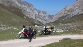
The second scenic part is the one circled on the map a bit more west – and where the photo of my GS is taken:


As said, we had to cut short because of shitty weather. I reserve to go back and explore the west part (routes for days 26 and 27th in the GPX) and the coast.
Following day we explored a bit of the coast closer to Canga, the Bufones the Pria, and the Cowabunga! Sanctuary in Covadonga, then retreated early in Canga De Onis - Hotel Mirador, fairly nice.


Canga de Onis:

Last couple of days we followed the tracks shared from Arsey. From Canga down south and back to Potes and then did the loop of the park on the following day, climbing all the way to what I thought was the Mirador del Fitu (that was actually miles away) but was the Amieva observation point instead.
On this last couple of days we were back in Potes but a different Hotel that I strongly recommend: the Casona De Barò, just a few miles off Potes in Barrio Barò.
On the first night we went out for dinner in Potes at La Soldreria, very good meal. We walked from the hotel in Barò to Potes and back (12km back and forth) that I recommend a bit less... especially if you get scared walking in complete darkness (bar a small torch) at night in the countryside.
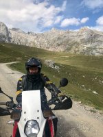
Some more assorted pics.
N621 after the climb from Ongayo:


My mate on what should be the P210 after Triollo I think:

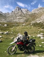
Near Amieva observation point:

One thing to note is that the N621 north of Potes is being rebuilt and there are 5 bits where they alternate traffic on a single available lane. It could take up to 30 minutes to cover just a few miles, so the full Picos loop currently is a bit of a pain to do - and given the size of the roadwork it will be like that for at least one year IMHO.
To avoid part of the closed road, on the north section we re-routed on the AS345 from Ribera till it rejoins the main road. Beautiful views and lots of very fun tight corners.
I have a few bits of roads captured on GoPro. As usual I'm uploading those so people can see what kind of roads they could encounter in the area (er-minio's streetview ) as we did in other threads. It will take a few hours, so I'll post them in a follow up message.
As said, planning to go back, hoping in better weather.")
Richard
=============
So.. Picos: a trip report.
Richard, split the thread if you think it's best.
I was originally meant to go travel across the Pyrenees meeting a friend from Italy, but he got caught on with work and had to travel to the US so diverted (with another friend) to the Picos area.
Have to say thanks a lot to all that shared routes over the years here in UKGSer and Arsery in particular (especially for the hotel tip).
I couldn't be bothered to do a usual long trip, plus friend traveling with me has a slightly slower pace, so kept things short and easy. We traveled about one thousand miles over 4/5 days, consider that we had to skip the west part of the route because of crappy weather so we traveled a bit less than intended.
This is pretty much the routes:
and the gpx file can be downloaded from here.
In the GPX file you will find a a route and track per day + a few waypoints.
We traveled on the Brittany Ferries Portsmouth to Bilbao line that was excellent. On time, staff is super friendly, new boats, have to say I was very impressed.
Get at checkin about one hour before the sailing time and you're golden. Enjoy the trip.
I was annoyed about the longer sailing time south (last time in 2019 it was quicker) but actually enjoyed one full day on the boat doing nothing much more than reading a book.
A very rare view of my GS when CLEAN.
First night we did stay at Hotel del Oso that has been excellent. I will try to stay a few more days next time.
Route there follows part of the Santiago walk and then towards the artificial lake "Embalse del Ebro". Medium fast flowing roads.
Following day we were directed east, but we knew we had to cut short for the weather.
We did a couple of detours from the routes downloaded from this forum. The LE-243 from Portilla de La Reina is a smaller less well kept mountain route but fairly nice/scenic.
Just beware of the random free roaming cows here...
The second scenic part is the one circled on the map a bit more west – and where the photo of my GS is taken:
As said, we had to cut short because of shitty weather. I reserve to go back and explore the west part (routes for days 26 and 27th in the GPX) and the coast.
Following day we explored a bit of the coast closer to Canga, the Bufones the Pria, and the Cowabunga! Sanctuary in Covadonga, then retreated early in Canga De Onis - Hotel Mirador, fairly nice.
Canga de Onis:
Last couple of days we followed the tracks shared from Arsey. From Canga down south and back to Potes and then did the loop of the park on the following day, climbing all the way to what I thought was the Mirador del Fitu (that was actually miles away) but was the Amieva observation point instead.
On this last couple of days we were back in Potes but a different Hotel that I strongly recommend: the Casona De Barò, just a few miles off Potes in Barrio Barò.
On the first night we went out for dinner in Potes at La Soldreria, very good meal. We walked from the hotel in Barò to Potes and back (12km back and forth) that I recommend a bit less... especially if you get scared walking in complete darkness (bar a small torch) at night in the countryside.
Some more assorted pics.
N621 after the climb from Ongayo:
My mate on what should be the P210 after Triollo I think:
Near Amieva observation point:
One thing to note is that the N621 north of Potes is being rebuilt and there are 5 bits where they alternate traffic on a single available lane. It could take up to 30 minutes to cover just a few miles, so the full Picos loop currently is a bit of a pain to do - and given the size of the roadwork it will be like that for at least one year IMHO.
To avoid part of the closed road, on the north section we re-routed on the AS345 from Ribera till it rejoins the main road. Beautiful views and lots of very fun tight corners.
I have a few bits of roads captured on GoPro. As usual I'm uploading those so people can see what kind of roads they could encounter in the area (er-minio's streetview
) as we did in other threads. It will take a few hours, so I'll post them in a follow up message.As said, planning to go back, hoping in better weather.
Last edited by a moderator: