(RIP) Bin Ridin
Registered user
http://www.irishtimes.com/newspaper/motors/2009/0930/1224255504909.html
GREAT DRIVES: Cod’s Head – from Eyeries to Allihies
THE BEARA Peninsula is one of the most rewarding places to explore in Ireland’s southwest, with its combination of rugged coastline,spectacular mountains and a high percentage of good roads.
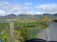
We’ve explored some of these roads in the past, most notably The Tim Healey Pass and the exceptionally beautiful Glanmore Valley and Lake. On this occasion we travelled down the northern shore of the peninsula along the R573, which hugs the coast as far as Lauragh, where it becomes the R571 to continue along the coast as far as Ardgroom.
From there, the road goes inland to Eyeries, and although a coastal alternative exists, the R571 is by far the better road.
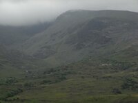
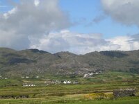
Eyeries is the start of our exploration, the oddly named town on the edge of Boulagh Bay featuring a mass of the cheerful and brightly coloured buildings which seem to be a feature of this part of Cork. At first, the R571 runs along some spectacular coastal scenery, and a look at the map reveals a seemingly vast number of prehistoric sites along this part of the coast. Otherwise, the landscape is dominated by the mountains of the Miskish range – Miskish itself, some 386m high, Knockoura (490m) and Knockgour (481m). Like the rest of our route, the road forms part of the Beara Way Cycle Route.
Having travelled southwest, the R571 turns north before once again resuming its south-west inclination, rising steadily to a pass between Knocknagallaun (376m) and Eagle Hill (223m), from where there are fine views back to the rugged coastline.
The next section of the R571 is notable for the remains of several copper mines, most notably Dooneen Mine. The mining was begun by a local landlord, John Puxley, in 1812 when several areas were identified as copper bearing. In total, six mines were operated in the area, with mining continuing until 1838 when they were closed down. A further attempt was made to operate the mines by Puxley’s son Henry in 1868 but with little success, and mining finally ceased in the area in 1878.
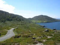
Having cut across the Cod’s Head Peninsula, the R571 now turns southeast and runs in spectacular fashion along the edge of a bay. The twists and turns of this short section provide some wonderful aspects looking towards Allihies Point and, further west, to Garinish Island. Also to the southwest lies Dursey Island, with it’s unique cable car connection to the mainland. All too soon, the road arrives at the town of Allihies, situated at the terminal ridges of the Slieve Miskish range.
From Allihies there are several options for further exploration of the Beara Peninsula. One may choose to continue southwest along the Beara Way through Bealbamish Gap and onwards along the southern coast of Beara to Castletown Bearhaven, or alternatively, continue further westwards along the peninsula towards Dursey island and the aforementioned cable car. Whichever you choose, this most interesting of the southwestern peninsulas will not disappoint.
This article appears in the print edition of the Irish Times
GREAT DRIVES: Cod’s Head – from Eyeries to Allihies
THE BEARA Peninsula is one of the most rewarding places to explore in Ireland’s southwest, with its combination of rugged coastline,spectacular mountains and a high percentage of good roads.
We’ve explored some of these roads in the past, most notably The Tim Healey Pass and the exceptionally beautiful Glanmore Valley and Lake. On this occasion we travelled down the northern shore of the peninsula along the R573, which hugs the coast as far as Lauragh, where it becomes the R571 to continue along the coast as far as Ardgroom.
From there, the road goes inland to Eyeries, and although a coastal alternative exists, the R571 is by far the better road.
Eyeries is the start of our exploration, the oddly named town on the edge of Boulagh Bay featuring a mass of the cheerful and brightly coloured buildings which seem to be a feature of this part of Cork. At first, the R571 runs along some spectacular coastal scenery, and a look at the map reveals a seemingly vast number of prehistoric sites along this part of the coast. Otherwise, the landscape is dominated by the mountains of the Miskish range – Miskish itself, some 386m high, Knockoura (490m) and Knockgour (481m). Like the rest of our route, the road forms part of the Beara Way Cycle Route.
Having travelled southwest, the R571 turns north before once again resuming its south-west inclination, rising steadily to a pass between Knocknagallaun (376m) and Eagle Hill (223m), from where there are fine views back to the rugged coastline.
The next section of the R571 is notable for the remains of several copper mines, most notably Dooneen Mine. The mining was begun by a local landlord, John Puxley, in 1812 when several areas were identified as copper bearing. In total, six mines were operated in the area, with mining continuing until 1838 when they were closed down. A further attempt was made to operate the mines by Puxley’s son Henry in 1868 but with little success, and mining finally ceased in the area in 1878.
Having cut across the Cod’s Head Peninsula, the R571 now turns southeast and runs in spectacular fashion along the edge of a bay. The twists and turns of this short section provide some wonderful aspects looking towards Allihies Point and, further west, to Garinish Island. Also to the southwest lies Dursey Island, with it’s unique cable car connection to the mainland. All too soon, the road arrives at the town of Allihies, situated at the terminal ridges of the Slieve Miskish range.
From Allihies there are several options for further exploration of the Beara Peninsula. One may choose to continue southwest along the Beara Way through Bealbamish Gap and onwards along the southern coast of Beara to Castletown Bearhaven, or alternatively, continue further westwards along the peninsula towards Dursey island and the aforementioned cable car. Whichever you choose, this most interesting of the southwestern peninsulas will not disappoint.
This article appears in the print edition of the Irish Times


")