Is there a standalone app for use on an old phone for navigation?

GBClassic

Member
UKGSer Subscriber
Joined
Oct 10, 2009
Messages
75
Reaction score
30
Location
Manchester, England
Hi
is there a stand alone app that you can download to the old phone and use it as a GPS/Sat nav?

Is there a way to define your route in the hotel the night before and then download them to the old phone?

George

=====

I have started you a fresh thread.

Richard
 
Last edited by a moderator:
Yes, several.

Possibly the most popular is MyRoute’s Navigation app, used in conjunction with MyRoute’s Routeplanner application, which is cloud based.

Everyone will have their favourite, sometimes based on nothing more than if it’s free.
 
Last edited:
Hi
is there a stand alone app that you can download to the old phone and use it as a GPS/Sat nav?

Is there a way to define your route in the hotel the night before and then download them to the old phone?

George

=====

I have started you a fresh thread.

Richard
Copilot works pretty well. I believe it may be subscription model now, when I got it, it was about £30 for all of Europe and lifetime updates. Maps of the US cost me an additional £12 from memory.
 
I use MyRoute app (predominantly) but also use OSMand+. MyRoute app is easier to use and the route planning aspect is better. OSMand+ is very good for tracks and can be used for other activities like hillwalking/mountain biking etc. It's cheap Maps+ subscription costs me £10 a year (£15 for new users). But it has a very steep learning curve.
 
I was out with a bunch of lads using Detecht. It’s free, but like many apps, the more you want to do in terms of route planning is where you can pay. But, you can also pay on a pay as go basis too or for just a one off month for a trip etc.
 
Is there a way to define your route in the hotel the night before and then download them to the old phone?

For very simple A to B to C routing, it’s very hard to beat Google Maps. Not least it’s free and works offline, just be sure to download the maps

It all depends on how bespoke you wish to be with your route creations. For example, MyRoute’s Routeplanner application can build very complex routes and export them seamlessly to the MyRoute Navigation app.

Perhaps you could let us know what you plan on using the navigation / creation applications for? Simple or complex? Free or paid for?

:beerjug:
 
The beeline app is excellent with really good topographical mapping. FOC and no need for a beeline head unit, just navigate from your phone.

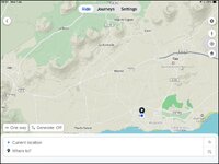
IMG_0449.jpg
 
We use Google maps as Wapping said and Gaia both require space to save maps and data and both can share across devices. You can create on one device and share/have a back up on multiple devices.
Google maps "free" Gaia free or paid for, we use paid for on trips where I've not got good mapping.
You'll almost certainly need and SD card in your phone for extra storage if you're intending to cover a large area.
Bluetooth or wifi hotpsot to your main phone if you have a good data contract will give you live traffic and better resources.
 
I go greenlaning and many of the usual nav systems don’t like routing on these, so I was recommended to try Guru Maps and it’s been excellent. Import Gpx files, tracks, etc, or just tap to add waypoints and it will generate the route. You can then share these and use them in a group ride. I use an old pixel 4a just for GPS duty as it has decent battery life.

I got a track sent to me before riding in Wales last week, loaded it into my GM app and generated the route so it would ‘stick’ to the roads/green lanes and we could navigate it easier than trying to see where the next ‘breadcrumb’ had been dropped and figure how to get to it.
 
Hi
I use an old Navman cos I like the option of showing TurnByTurn, I can see the next 5 turns on the screen and as I go along it scrolls up.

The problem is the maps are out of date and no updates are available.

I usually just use it for
* the last couple of miles to find a location
* the first few miles to get out of the urban jungle
* to rescue me if I get lost bimbling
But leave it on in the car as a confidence thing in case I loose focus and find I dont recogise where I am

George
 
Waze is good and free. Updated by other users, although they are annoying as fuck if an ambulance passes them heading in the same direction as you, as they report the ambulance where it passed them and so do other users ahead, so you get a string of notifications about an emergency vehicle that you saw before anyone told you about it.
 
This thread shows that you need to tell us, please:

A. What you intend to use the app for, not least as there is a significant difference between use on-road and off-road.

B. How bespoke / complicated you want to make the routes you create yourself

C. Whether you want to pay for the application(s).

D. Probably how large an area you might like to cover with the downloaded maps?

E. How old / the model your ‘old phone’ is, as this might dictate whether (as some have suggested) it can even take an SD card and / or whether its internal memory can take a map much larger than the High Street in Lower Piddle cum Slaughter.

Or, all you’ll get is more and more lists of app’s and Lord knows what else.

:beerjug:
 
Last edited:
This thread shows that you need to tell us, please:

A. What you intend to use the app for, not least as there is a significant difference between use on-road and off-road.

B. How bespoke / complicated you want to make the routes you create yourself

C. Whether you want to pay for the application(s).

D. Probably how large an area you might like to cover with the downloaded maps?

E. How old / the model your ‘old phone’ is, as this might dictate whether (as some have suggested) it can even take an SD card and / or whether its internal memory can take a map much larger than the High Street in Lower Piddle cum Skaughter.

Or, all you’ll get is more and more lists of app’s and Lord knows what else.

:beerjug:
And is it an iPhone or Android. …
 
Hi
A. On-road only.

B. Not very complicated but quite a few towns to make it go where I plan like the vias in google maps

C.Free if possible.

D. 100 miles x 100 miles

E. I planned to buy an Android phone for the job,


I tried google maps today, it sort of worked. Until I took first left not second one. Google maps then led me 10 miles away, over and around before taking me back to my destination, 2 miles along the second left.

George
 
You’ll be just fine with Google maps, trust me.

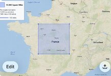
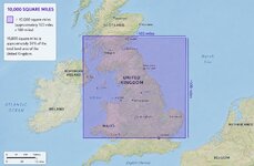
PS 100 miles by 100 miles is 10,000 square miles. That’s a hell of a big big area, if you just want to go town to town to town.

Here’s what it covers in France:

IMG_0190.jpeg

And here it is for the UK:

IMG_0191.jpeg
 
Last edited:
Hi
Yep a stupid idea of size. I sort of thought how far will I ride in a day= 100 miles (gone are the days of riding far) so I need maps that long, so they may as well be that wide.

I will see how I get on with google maps

George
 
You’ll be just fine with Google maps, trust me.

PS 100 miles by 100 miles is 10,000 square miles. That’s a hell of a big big area, if you just want to go town to town to town.

Here’s what it covers in France:

View attachment 517364

And here it is for the UK:

View attachment 517365
I think the UK map is a smidge off... But still a big area!


Back
Top Bottom