Willstatt:
Before I can answer your question, I need to help you sort out the different software components that are used with Garmin electronic cartography, because you are (unknowingly) confusing apples and oranges here.
MapSource is the program (application, executable) that is used to view electronic maps, to download segments of these maps to your GPSR, and to create, manipulate, and upload/download waypoints, routes, and tracks.
MapSource contains NO MAPS! It's strictly a data manipulation tool. The most recent version of this tool is 6.1, and this can be downloaded free of charge from the Garmin website. Note that if you are not running Windows 2000 or later, you should stick with the previous version of MapSource, which is 5.4.
MapSource is included on every cartography CD that Garmin produces. When you install your first cartography CD on your computer, MapSource is installed. If you install additional cartography CD's later, MapSource will be updated automatically, if the subsequent CD has a newer version on it. But, even if you have 10 different Garmin cartography products installed on your computer, you will (normally) only have one version of MapSource present.
The maps themselves are referred to by various product names - City Navigator, City Select, MetroGuide, and so on. Each of these products has multiple versions, because the map products are normally updated about every 12 to 18 months. For example, the current version of City Navigator for Europe is version 6.
It is possible to be running an out of date version of MapSource (the map viewing tool) with a current version of a mapping product, and it is also possible to be running a current version of MapSource with an out of date mapping product. Such slight mismatches are generally no big problem, though if I had a choice, I would want the newest map product, rather than the newest MapSource program.
For a more detailed explanation of the history (genealogy) of the various Garmin mapping products, and how all these different components (MapSource, maps from CD's, basemap) work together, have a look at this post, which I made in another motorcycle interest group:
Garmin V - Buying a US Version for European/RTW use
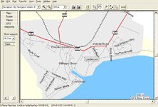
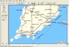
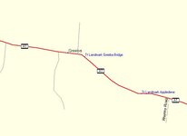
About the Isle of Mann: OK, having cleared all that up - I have CityNavigator Europe version 6, it shows quite a bit of detail for the Isle of Mann, below are some photos:


 .
.
