Map holder for 12GS

The White Rabbit

Registered user
Joined
Jan 26, 2007
Messages
661
Reaction score
0
Location
North Somerset
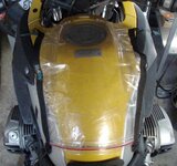
Has anyone come up with a solution for attaching OS maps to the GS. Ive GPS and tank bag etc but dont want to run with the tankbag just to have somewhere to put a map. I tried a cycling type map holder but it didnt seem a good solution.

Ive posted this in 1200 section as the plastic tank excludes some magnetic options.

Oh and I'm thtough with wedging it down behind the clocks. Works fine until you realise its shaken its way out.:blast
 
I've just got one of the TT day bags, has a removable map pocket on top, which is attached with Velcro, a cheap solution would be to get a map pocket from the :ymca 
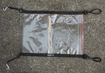
shop and attach with Velcro to your bag :thumb2
 
I've tried everything, with no success. I even bought a map holder with suckers (incluidng the one who bought it) but even they don't stick to the paint on the side panels. They seem to until you reach about 80 when the holder flies up and hits you on the helmet. Properly secured tank bag is the only option. I did fleetingly even think about one of those roller route holders they advertise in Old Bike Mart - that clip onto the handlebars. But figured that was taking it too far.
 
Perhaps not that elegant - a waterproof map case as used by walkers and some electrical insulating tape; it works and the tape leaves no permanent scars.
Get a designer map case and designer tape - be the envy of your mates.
Goan goan goan:aidan
 

Attachments

  • DSCF0043.jpg
    DSCF0043.jpg
    69.4 KB · Views: 445
Try a GPS.:) All your maps nicely sorted and stored away safely & conveniently. Unlike maps with a GPS you can be more flexible when touring & keep your eyes looking more often at the road & scenery (even in the rain). You can even plan to ride through a city and B roads without drama. I know they are expensive & techy, but I think they are one of the best bits of kit you can hang off your GS.:thumb2
Good luck. (From Tom Thomas sales Director):D
<?xml:namespace prefix = o ns = "urn:schemas-microsoft-com
forums
<o:p></o:p>
 
:o oops!
Just out of curiosity.. Are the OS maps for riding of hiking?:D

Both ;) . No what I need is a map holder so I can use my OS maps looking for trails and byways etc, and then waypoint them on the GPS. I know I could waypoint them sat at home, but I likes exploring I do and I like looking at the detail on the maps (terrain etc).
 
Howz about a thigh pocket thingy??

I've seen them on sale but can't remember where.....a plastic ziplock envelope with two adjustable velcroed elastic straps......strap it on your leg so it's on the top of your thigh.....no good for using in motion I spose but all you need to do is pull up and look down??
:nenau
 
I think you are pretty much at just going to the Hiking shop, buying a waterproof mapholder...

Then figuring out how to bodge a mount out of some welding rod to hold the straps on the front side so that it's all held horizontal... strap the back corners down with some elastic so you can pull them up to look at them... pretty easy no?

This seems like a good thing to make using the mounting hardware for that tank-bag thingy that attaches to the fixture on the fuel filler point... (forget the name... Nippy Norman sell em... ) Easy on/off for fueling... (maybe they already do one?)

http://www.nippynormans.com/prodinfo.asp?number=SWM-QL-MAP&variation=&aitem=127&mitem=225

:rolleyes:

This attaches to the bag, but It's be a cinch to make something that gets you map only to the same mount I bet...

Al...

Yes, I think its back to modding something from a map bag. The fuel filler thing is an excellent idea tho. That would be neat.
 
There are some things about

http://www.roadgear.com/catalog/index.cfm?Series=2&brand=8&BrandTitle=Map Holder

http://www.getgeared.co.uk/acatalog/Louis_International_Strap-On_Map_Holder.html

They all look a little too small for OS tho. I'm almost tempeted to buy the latter and use the straps bodged onto a nice sized Ortlieb map holder. I shopukld be able to make some kind of attachement on the lip of the tank plastics and then onto the velcro...or even zip if I want to go the whole hog of my tankbag connector.
 
The bees knees

Made this yesterday
Ingredients
A sealline mapcase, medium http://www.seallinegear.com/all_purpose.asp?Action=MapCase&Category=AllPurpose
Four rubber bands as cut from a motorcycle tube or similar.
Two plastic hooks - I found old curtain hooks and modified them, you may find a better alternative.

Wrap the rubber bands through the corner D rings.
Include the plastic hooks in the forward side rubber bands.
See the photos.
Blue Peter lives on.
Pure genius -
E mail me the royalties please.
 

Attachments

  • P5210002.JPG
    P5210002.JPG
    71.4 KB · Views: 304
  • P5210003.JPG
    P5210003.JPG
    67.1 KB · Views: 302
  • P5210004.JPG
    P5210004.JPG
    32.8 KB · Views: 305
  • P5210005.JPG
    P5210005.JPG
    40.1 KB · Views: 302
  • P5210006.JPG
    P5210006.JPG
    51.4 KB · Views: 293
The Wunderlich Tank Bag also comes with a detachable map holder which can be fixed on your tank without the bag :thumb
 
Memory Map

Ive got a GPS. This is for OS maps.

There is a program called Memory Map which runs on PCs, PDAs and a few GPS units. The program runs with OS and other digitised maps and its possible to scan your own maps and use them in the program. It doesn't provide routes in the same way as Mapsource and Autoroute but you can define waypoints to put a route together and it will show distances between waypoints, elevation changes and calculate time based on your defined speed. For walkers it even works out extra time needed for climbing. Lots of other stuff such as 3D map views and `fly through' of routes. You can also print OS map sections on A4. I have printed maps and laminated them for use on the bike. They can then be used in tank bag or just bungeed to tank.

If its used with a PDA with a gps it will lock onto your position on a moving map and record a track log.

I use it on an IPAQ with an internal gps receiver. Great for walking and car use. So far its only been used in the tank bag on the bike but looking at RAM mount or similar for a better installation.

Downside is the maps can be a bit pricey if you want lots - unless you know what a `torrent' is.


Back
Top Bottom