Hi All, thanks for the great advice and tips. I will try those later. I never had this problem with my Z660, it behaved quite nicely and did exactly what I asked it to.
I thought I was a bit of a whizz with the Nav V but its finding new ways to frustrate me every time.
The problem is when I pick the route I want. It asks me "
Select Next Destination", what ever I select in recalculates the route to that point instead of navigating the route I have already defined. What I want it to do is to take me round the route I have defined. If I look at the "Map" the route is exactly as I wanted it. But I can't seem to be able to ride/drive that route.
Yes I used Basecamp. Also Google Maps, Bing Maps, GPS Visualiser, Furkot, and Tyre.
I can't find any option to turn recalculation off ?

I get the same issue whether I use MyRouteApp, GPS Visualizer or Google maps. The map looks correct on the application,and also looks fine when transferred to the Nav V (KML, GPX GDB, CSV). But then I can't drive it cos the Nav V recalculates it when I ask it to go somewhere. I have lots of way points on the route and the NavV asked me which one I want and then calculates its own routes to that point and not the route I have planned.
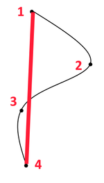
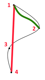
For example (see image). I have a route (in black) with 4 way points. When I transfer to the NavV I can see the route as expected. Using the Trip Planner I select the route and it says "Select Next Destination" and presents all 4 way points. If I select "4" I get the route recalculated (shown in Red). If I select "2" then I get the route (shown in Green). All I want to do is drive/ride the route shown in Black.