Off-roading in Gloucestershire

Mav

Well-known member
UKGSer Subscriber
Joined
Aug 12, 2006
Messages
5,443
Reaction score
3
Location
Glos.
Hi All

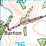
Just been looking for some 'green-lanes' in the Gloucestershire area and I found these legal lanes on around Kineton (I'm working on the basis of red-dot paths being legal - correct? :confused: ). There are also a few not so legal ones....

http://www.streetmap.co.uk/newmap.s...srf&searchp=newsearch.srf&ax=409436&ay=226714

Any of you been down these lanes? If I get my bike back from BMW (another story!) I was thinking about trying them on Saturday...

Mav
 
WARNING

Be very careful around all the green lanes in the Cotswolds, as most are either subject to TRO's or have been down graded to either footpaths or bridleways.:spitfire

In otherwords, this means that you cannot ride them!

If I were you and to be on the safe side, pay a visit to your local County Records Office and just double check the vehicle status of the ones that you intend to ride.

Sadly, once upon a time you could enjoy a full weekends off riding around this area, but not anymore. :nono

Thanks for the warning!

I will check out the County Records office - but I had thought that if a route was marked with red-dots (see below) on an OS map that it was still legal and that OS maps tend to be fairly up to date... is this not the case?
 

Attachments

  • reddots.gif
    reddots.gif
    18 KB · Views: 4,346
To be fair the one that you detail is ok, or at least it was! But its nothing to shout about to be honest!

Lanes marked on OS maps "can" be out of date the day after they are drafted in the case of TRO.

However, they are a dam good starting referance point, especially the orange coloured Explorer range. Buy a few of these and take then to the County Office and get them checked.

Then buy the red Landranger maps and transfer the data on to them. This then saves you carrying half a dozen Explorer maps for a days ride. :thumb

It also means that you will always have a master copy at home. :D

My suggestion however would be to join your local TRF group in Gloucestershire and say hello to Charlie for me!

The ROW man will see you ok.

Hope that helps and answers your question?

If you can make it to one of the West Midlands meeting I can talk in more detail about the subject.
 
TRF

If you plan on riding many Green Lanes (the ones left that is :rolleyes: ). It may be worth joining the TRF and finding the local meet.

Just a thought :thumb

Cheers, Piggers
 
The one you detailed is NOT gs able, it goes through a field with no track to follow. The original map section you show has a track a little to the left of the red arrow, that one's OK, it's a byway. As BTBR says come to a meeting we'll fill you in on what's rideable (bring a map).
 
This is me couple of weeks ago on the fosseway, between sherston and kemble, very slippy but good fun.:thumb

fosseway.jpg
 
I'm out in Lechlade and would be interested in finding out more, how do I find you guys to know when your next meeting is?


Errrr......look in the West Midlands section at the "sticky" thread at the top of the page, this could be considered a good starting point maybe :rolleyes:

Other than adding neon flashing lights and a topless Go-Go dancer, I'm not to sure how more visable I could make it?
 
hmmmm sarcasum... cheers

so... why west midlands, when Gloucestershire is listed under South West and is the closest meet really in Alcester, the best part of 50 miles from me ;-)
 
hmmmm sarcasum... cheers


Sorry........:o

so... why west midlands, when Gloucestershire is listed under South West and is the closest meet really in Alcester, the best part of 50 miles from me ;-)

Simple, no one down your way has started a local meeting :nenau

So here is your chance to shine..;)
 
The one you detailed is NOT gs able, it goes through a field with no track to follow. The original map section you show has a track a little to the left of the red arrow, that one's OK, it's a byway. As BTBR says come to a meeting we'll fill you in on what's rideable (bring a map).

Thanks for the offer John - I'm hoping to be in the right country for the next meeting at the Arrow Mill so I'll bring a map :thumb
 
To the man in Lechlade, tell you what, I'll do you a deal, come to Stow (20mls) and I'll take you from there. Mind you it'll probably be in the car. No surprise there then! Next meeting is 6th Feb?
 
My understanding is the meeting is on the first Tuesday of the month... in Feb that is the 6th :beerjug:
 
BTBR said:
Maybe the South West section would be a better place to start?:nenau
Debatable. :D

Set odometer to zero, ride Gloucester-Gretna Green, note reading. Repeat Gloucester-Lands End. Compare. :thumb

Regards, Mick

p.s. I'll be at the Winget Wednesday fortnight.
 
Here's what i got. . . . .

Please find attached a list of the BOATs in Gloucestershire and an outline county map showing their approximate location. You will see from the listing that there are only ten byways open to all traffic in the county. No review of RUPPs took place within Gloucestershire under the 1968 Countryside Act and only a small number of RUPPs were reclassified under Section 54 of the 1981 Wildlife and Countryside Act; the remaining RUPPs have become Restricted Byways under Section 47 of the Countryside and Rights of Way (CROW) Act 2000, which came into effect on 2 May 2006.

Andrew Houldey
Modification Orders Officer
Public Rights of Way
Gloucestershire County Council
01452 425522
 

Attachments

Here's what i got. . . . .

Please find attached a list of the BOATs in Gloucestershire and an outline county map showing their approximate location. You will see from the listing that there are only ten byways open to all traffic in the county. No review of RUPPs took place within Gloucestershire under the 1968 Countryside Act and only a small number of RUPPs were reclassified under Section 54 of the 1981 Wildlife and Countryside Act; the remaining RUPPs have become Restricted Byways under Section 47 of the Countryside and Rights of Way (CROW) Act 2000, which came into effect on 2 May 2006.

Andrew Houldey
Modification Orders Officer
Public Rights of Way
Gloucestershire County Council
01452 425522


Sadly gone forever.............:spitfire


Back
Top Bottom