Roads and Recreation?

beacon

Registered user
Joined
Dec 13, 2002
Messages
322
Reaction score
0
Location
Leeds w.yorks
What does the Roads and Recreation CD have on it? I have a 2610 with CN 6 what would the RR add to that? can you use them together? Do you need unlock codes with it? will my exsisting ones(codes) work with it? ets etc. any help would be good, many thanks. Chris
 
Hi Chris:

Roads and Recreation is the name that was given to a family of map products that Garmin produced and sold in the mid to late 1990's. The maps were pretty rudimentary - about the best that could be expected at the time, considering the whole industry of electronic street mapping was in its infancy.

They were sold by country, for example, R&R France, R&R Switzerland, etc. They did not support any kind of automatic route generation - either on the PC or on the GPS. They had no unlock codes, because unlock code technology had not yet been invented.

Any CityNavigator, CitySelect or MetroGuide product with a version number of 4 or higher will be much, much newer and contain far more detailed information than any R&R product. The MetroGuide map family (which does not require an unlock code, and supports automatic route generation on the PC, but not the GPSR) has since replaced R&R. When you buy a MetroGuide CD today, you get all of Europe, or all of Canada or the USA on 1 CD.

The only possible use I can think of for a R&R CD today would be if someone has a very, very old GPSR - more than 5 or 6 years old - that only has one megabyte of map storage space in the GPSR, and therefore might not be able to accept a download of even one segment from a current MetroGuide map product.

You currently own CN6, which is the latest version of the most detailed map product that Garmin offers. Comparing R&R UK to CN Europe 6 is like comparing DOS 1.0 with Windows XP Pro. Even if you offered me a $1,000 commission, I couldn't find a single map product for you that would do the job better than what you have. As you might guess, what you use (CN6) is exactly what I use as well.

PanEuropean
 
Thanks Pan thats all the info I wanted, nice and easy, I just wonderd if it gave you an option for green lanes etc, I didnt realize it was old tec. Thanks again.
Chris
 
PanEuropean said:
Roads and Recreation The maps were pretty rudimentary -


I disagree with you Pan.
I've recently been planning a route around the USA for next year. I've found that the roads are in a similar place but the R&R maps have loads more POIs on it. And I mean LOADS more. And before you ask...Yes, I have got the unlock code for it.
If you have access, centre on Salt lake city at 15mile scale then switch between "North America City Navigator v5" and "US R&R - Continental US". The latter gives you parks and airports and all sorts of orther things.
Also the details of the city road network only appear when the scale is 1 mile with "Navigator". AND, out in the back country the R&R shows many more dirt tracks than Navigator.
 
Hi Howard:

I hear what you are saying, but I think that you are seeing more POI's only because of the way R&R is encoded, not because there are actually more POI's in R&R than there are in CN, CS, or MG.

I don't own R&R - have not used it since I bought my SP III in 2001, because the SP III came with CN. So I can't investigate this further at my end. But here's an experiment you can do to see if my theory is correct:

Open each product with MapSource, and set the zoom level to a very, very tight zoom on the center of a big city - say, 100 foot scale on downtown New York. That should ensure that all POI's show up on both products. Then compare the results. The question of POI coverage is kind of academic anyway - all the R&R products have been discontinued by Garmin, therefore the R&R POI database will be less accurate (less up to date) than CN, CS or MG. The most recent version of R&R USA was released either during or prior to the year 2000.

Concerning quantity of roads displayed, again, I think this might be due to data encoding, rather than content. CN and CS divide roads into more classification levels than R&R, therefore, these multiple layers reveal themselves at different zoom settings. If you again compare both products at a very tight zoom-in level, I think you will find that CN, CS, or MG have at least equal content.

North American R&R cartography was compiled by a different company than the company that collects cartography for the current shipping versions of CN, CS and MG, so you might see some differences in the coverage. Historically, R&R in the USA had more rural secondary road detail than CN or CS, because this data is free and placed in the public domain in the USA. CN and CS put the priority on collecting metropolitan (city) data first, as can be inferred from the product names.

I was unaware that R&R ever shipped with an unlock code. My understanding was that this product existed to support the GPSR's that were manufactured before unlock code technology was invented.

PanEuropean
 
PanEuropean said:
Hi Howard:

I was unaware that R&R ever shipped with an unlock code.
PanEuropean

It wasn't. Iwas saying that I had the code for the "Navigator" CD.

As for your other points. I'm sure the city detail is AS if not better on the new Navigator CD, but out of town there is deffinately more POIs on the R&R including dirt tracks. This could be explained by your knowing that the mapping was compiled by a different company.
 
Hi Howard:

Thanks for the update. If you have time, try the experiment I suggested above, comparing R&R and CN at very tight zoom levels. I don't have any R&R cartography anymore (I probably have the original CD's somewhere at home, but I am in Europe now). Anyway, go to Salt Lake City, where you mentioned that R&R showed more parks, airports, etc. at the 15 mile scale, and then switch to CN NA and zoom in a bit, and see if those same POI's are there on CN, but just not revealed when CN is displayed at the 15 mile scale.

You might be able to bring up additional CN data on the computer screen at wide views if you adjust the 'level of detail' slider on the MapSource preferences menu. I think it's a layering issue - R&R shows its (fewer) layers at wider zoom settings than CN, but the info will still be there on CN if you drill down.

You can figure out who the supplier of map data is on all of the Garmin cartographic CD's by looking for their name on the paper cover of the CD Jewel Case. It's always there somewhere on the printed CD paper cover or liner notes, or in the text that provides the copyright information - either NavTech (now Navteq), Etak, DTMI Spatial, or others. Here's a link to an advertising brochure that Garmin released in back 2000 showing the different American CD's available at that time:
[url]USA Cartography Brochure[/URL]. Although the R&R CD has since been discontinued, the US Topo CD's might also be of interest to you, especially if you are thinking of doing some off road riding or hiking. The Topo data doesn't have the same problems associated with going out of date as quickly as the road data. But, having said that, the "US Topo 24K" product - the one that comes in East and West versions - is the newest and most up to date of the topo map products. These won't support autorouting, but they work perfectly with the automotive GPSR's.

PanEuropean
 
Perhaps one of the things you are seeing is that R&R is displaying minor roads at higher zoom levels ?
If this is the case then it would be a major plus for this product (in spite of the old data).

I find that when biking or 4WDing in rural areas having to set the detail to 'Most' and still having to zoom in means that I can only display a small area on the unit if I want to see minor roads.
In these areas often minor roads are all that exist.

I understand that dropping minor roads is done deliberately as otherwise in metropolitain areas the screen would just go black with excessive detail. However, this process creates significant problems when travelling in rural areas and is something that I would like to see Garmin address.
 
Hi Burnie:

I was actually referring to the layering of the display Howard was seeing when the maps are viewed on the PC using MapSource, although the same does happen, I expect, on the GPSR as well.

What I think Howard is encountering (I can't tell for sure, because I don't have any R&R loaded on my PC) is that R&R has fewer layers of detail (for example, let's say only 4 layers), whereas CN or CS have, let's say, 7 layers. So, R&R will appear to display more detail at wider zoom levels, just because it is not as progressive in the way it reveals the layers as CN and CS are.

There is a fix for both viewing environments (PC or GPSR), and that is the "level of detail" setting. When viewing the maps on the PC using MapSoucre, users can adjust the scale at which various levels of detail are revealed by using the "Map Detail" slider, which is found under EDIT / PREFERENCES then selecting the DISPLAY tab.

There are some limits, of course - hiking trails won't be displayed at 30 mile zoom settings - but moving this slider to the right, towards the 'higher' setting, will cause the lower ranked, subsidiary layers of the maps (the ones with the residential streets, hiking trails, rural secondary roads, etc.) to appear sooner when you start to zoom in.

The same goes for the GPSR's themselves. Most of them have a setting called "Map Detail" - I know the SP III, SP 26xx and GPSMAP 2x6 series do - setting this to 'more' or 'most' will reveal the finer layers of detail at higher zoom settings. It's quite practical and worthwhile to adjust the display setting to suit your environment on the GPSR - if you are in a rural area, you can crank it up to 'most' and leave it there as long as you are in a rural area. That's what I did when I toured the Western United States last summer. As I moved towards the more heavily populated Eastern part of the country, I moved the display setting from 'most' to 'more', then finally back to 'normal'.

PanEuropean

PS: This trick can be used to good effect here in Europe when riding in countries that have patchy or incomplete map coverage, such as Ireland or Spain. As soon as you are out of the big cities that have residential street detail, crank the zoom level on the GPSR up to 'most', and you will see a lot of stuff that you might otherwise have thought was not there. If the cartographic coverage is incomplete, the roads that are there might not always be allocated to what would be, for that version of the cartography, the correct display level (because the cartographers are assuming the missing detail will be added in later versions to the level it belongs to).

It is worth mentioning that for autorouting purposes, a road does not need to be displayed on the screen for the GPSR to consider it or use it when you ask for autorouting. The GPSR will always consider everthing that is there, whether you can see it or not. This explains why occasionally you will see a magenta track line without a road underneath it at certain zoom levels. The road is there, for sure, it's just that the display settings are such that the layer that road belongs to has not been revealed yet.

 
Re ; the dirt track thing. The dirt tracks are just not there on the City Navigator mapping.
I always have my settings on "High". Don't want to miss anything.

Anyway, if you are right Pan, that the R&R CDs are no longer available. What are the owners of GPSRs such as the E-Trexs Vista supposed to do? I have 24MB of mapping memory which, as the years go by, will be loaded with out of date mapping.
Although I havn't tried, I believe that the City Navigator type mapping will not load onto these units.
Garmin should re-think.
 
Hello Howard:

MetroGuide replaces R&R. MetroGuide does not require an unlock code, and has much smaller map segments than CN or CS.

The only users who really will have problems in the future are users who have GPSR's that are more than 5 or 6 years old, such as the GPS III+. Some of these very old, first generation handheld units only have 1 meg of storage capacity for cartographic data. This might not be enough in the future to store an up to date map segment for a portion of a large city. Owners of these very old GPSR's will confront the same problem that owners of computers of the same age confront: Either stick with the software that they are currently using, or toss the thing and upgrade.

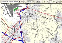
About "dirt tracks" - the photo below shows the area next to the hotel I am staying in, in Zürich. All the 'broken' lines that you see in the middle and towards the right of the screen are either pedestrian paths, hiking trails or forest service roads. The two parallel roads that you see just off the threshold of runway 34 are cart paths, only suitable for farm vehicles or dirt bikes. This is CN version 6, with the detail setting at the highest level.

PanEuropean
 

Attachments

  • paths.jpg
    paths.jpg
    120.5 KB · Views: 55


Back
Top Bottom