Hi Burnie:
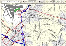
I was actually referring to the layering of the display Howard was seeing when the maps are viewed on the PC using MapSource, although the same does happen, I expect, on the GPSR as well.
What I think Howard is encountering (I can't tell for sure, because I don't have any R&R loaded on my PC) is that R&R has fewer layers of detail (for example, let's say only 4 layers), whereas CN or CS have, let's say, 7 layers. So, R&R will appear to display more detail at wider zoom levels, just because it is not as progressive in the way it reveals the layers as CN and CS are.
There is a fix for both viewing environments (PC or GPSR), and that is the "level of detail" setting. When viewing the maps on the PC using MapSoucre, users can adjust the scale at which various levels of detail are revealed by using the "Map Detail" slider, which is found under EDIT / PREFERENCES then selecting the DISPLAY tab.
There are some limits, of course - hiking trails won't be displayed at 30 mile zoom settings - but moving this slider to the right, towards the 'higher' setting, will cause the lower ranked, subsidiary layers of the maps (the ones with the residential streets, hiking trails, rural secondary roads, etc.) to appear sooner when you start to zoom in.
The same goes for the GPSR's themselves. Most of them have a setting called "Map Detail" - I know the SP III, SP 26xx and GPSMAP 2x6 series do - setting this to 'more' or 'most' will reveal the finer layers of detail at higher zoom settings. It's quite practical and worthwhile to adjust the display setting to suit your environment on the GPSR - if you are in a rural area, you can crank it up to 'most' and leave it there as long as you are in a rural area. That's what I did when I toured the Western United States last summer. As I moved towards the more heavily populated Eastern part of the country, I moved the display setting from 'most' to 'more', then finally back to 'normal'.
PanEuropean
PS: This trick can be used to good effect here in Europe when riding in countries that have patchy or incomplete map coverage, such as Ireland or Spain. As soon as you are out of the big cities that have residential street detail, crank the zoom level on the GPSR up to 'most', and you will see a lot of stuff that you might otherwise have thought was not there. If the cartographic coverage is incomplete, the roads that are there might not always be allocated to what would be, for that version of the cartography, the correct display level (because the cartographers are assuming the missing detail will be added in later versions to the level it belongs to).
It is worth mentioning that for autorouting purposes, a road does not need to be displayed on the screen for the GPSR to consider it or use it when you ask for autorouting. The GPSR will always consider everthing that is there, whether you can see it or not. This explains why occasionally you will see a magenta track line without a road underneath it at certain zoom levels. The road is there, for sure, it's just that the display settings are such that the layer that road belongs to has not been revealed yet.