Monega path comes out at the 'Shand Spittal' bridge in Glen Clunie. Local name again.
The black paved road you mean,is it below the current A93? If so that is the old Devils elbow,.
The old military road comes across the back of an old pillbox not far from the now A93. Built to stop the germans invading Braemar!
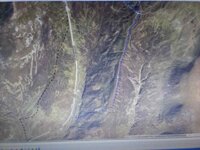
No, not the Devil's Elbow. It's in the middle of the photo.
You referred to the middle ridge in the picture, the one without the snow. That's what I think is Leacann Dubh, as marked on the photo with blue dotted line.
This is a fine ridge and because it is such, would probably be clear of any heavy snow. This would probably be a good route for access between the Spittal and Braemar.
Hence we can see it clearly just now with virtually no snow.
I can also see what you mean by the route eventually coming out at Glen Cluanie. Tends to keep to the ridges and avoids any potentially deep snow drifts.
A good 'hospital' route. 'Hospital' as in 'hospitality' - places to stay/rest and get food and lodgings.
The Devil's Elbow road must have got blocked a lot because it is closer into the river bed. More susceptible to snow drifts.
Interestingly the 'proper' Old Military Road, marked with black dotted line keeps out of the river bed and as I have said already climbs and contours into The Cairnwell as the same spot as the 'new' road and the Devil's Elbow road.
Good old William Roy, surveyor of many a Scottish Military Road.
BTW Is this a rhetorical question about knowing the local name for the ridge??
ps enjoying this, but I feel we may have hijacked this thread......