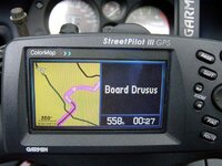
How CN handles ferries varies quite a bit from country to country. In Germany and Switzerland, it is seamless - the ferry doesn't even show up as a ferry per se, it is just considered a continuation of the road. When you reach the point where you should get on the ferry, you get a next turn screen that says "Board Ferry", except that it substitutes the proper name of the ferry for the word "Ferry".
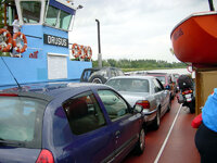
In other countries, the transition from land based road to the water based ferry is less sophisticated - the road ends out in the water, and then there is a line drawn across the water, which has the attributes of a road (same speed limit, etc.).
Obviously, this is a cartography (Navteq) issue and not a Garmin issue, but I don't know why it is inconsistent from country to country. My guess is that Navteq has just not got around to researching all the ferry attributes in cases where the government of the country concerned has not supplied them. In the case of international ferries, it could be that neither country (at each end) figures the ferry is their problem, as far as that country is concerned, their road ends at the water.
Below is a picture showing how the SP III handled a German ferry back in 2002 - this was CN Europe 4.0, if I recall correctly.
PanEuropean