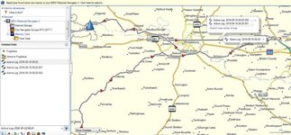
Awesome outing following another 'Tosser' through mid Wales. Places I've never heard of let alone been. There were 3 stops. NAV V recorded 1 full track of the day, and two parts of that track.
Question 1
When you stop on track, switch ignition off, at what interval in time does NAV V make that a hard stop in recording? I.e. It becomes a part of a the day's track so you will need to stitch them all together to make a route. It seems odd to me that I had a full track and part tracks when I downloaded to basecamp?
Question 2
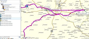
The full track actually had a straight solid grey line for the last 10 miles of the track as well as the actual track I took which was dotted. Converting it to a route I was unable to take the solid line out as it was somehow connected, so deleting it meant I lost much of the route. Why would it create a straight line? I didn't fly!
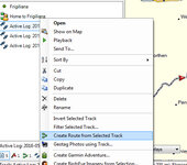
In the end I used tracks as a template and created a new route over it, but not very efficient!
Comments, piss takes welcome. And no I didn't have cross country on.
Question 1
When you stop on track, switch ignition off, at what interval in time does NAV V make that a hard stop in recording? I.e. It becomes a part of a the day's track so you will need to stitch them all together to make a route. It seems odd to me that I had a full track and part tracks when I downloaded to basecamp?
Question 2
The full track actually had a straight solid grey line for the last 10 miles of the track as well as the actual track I took which was dotted. Converting it to a route I was unable to take the solid line out as it was somehow connected, so deleting it meant I lost much of the route. Why would it create a straight line? I didn't fly!
In the end I used tracks as a template and created a new route over it, but not very efficient!
Comments, piss takes welcome. And no I didn't have cross country on.