

You are using an out of date browser. It may not display this or other websites correctly.
You should upgrade or use an alternative browser.
You should upgrade or use an alternative browser.
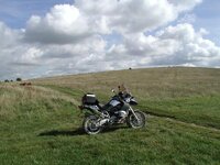
The Ridgeway and Feeders (between Streatley and the A34)
- Thread starter Clive
- Start date
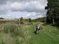
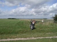
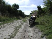
SU 550 843 to SU 537 825
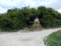
Same location as the last photo - according to the OS Map the RUPP veers off right here and the chalk track is not "listed" - however there wasn't an easy way onto the mapped "RUPP" so I kept on the chalk track. Perhaps this is why the track is now shown as a Byway, since when I reached the other end, the route of the RUPP is inaccessible (signposted "Private" and fenced off by field boundaries). The "old" RUPP ends up at SU536825.
Same location as the last photo - according to the OS Map the RUPP veers off right here and the chalk track is not "listed" - however there wasn't an easy way onto the mapped "RUPP" so I kept on the chalk track. Perhaps this is why the track is now shown as a Byway, since when I reached the other end, the route of the RUPP is inaccessible (signposted "Private" and fenced off by field boundaries). The "old" RUPP ends up at SU536825.
Attachments
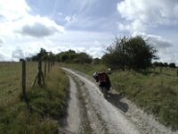
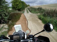
SU 539 815 to SU 544 826
Location: SU539815/SU544826
Map: Explorer 170
Date: 14/09/2005
Weather: Dry, Rain a few days ago
Difficulty: 1 - Easy unsurfaced road, suitable for a novice on road tyres.
Status: Byway
Source: OS Map
Restrictions: None
Notes: One of the standard Ridgeway surfaces - wide shallow stone/flint track with grass centre ridge. Some parts recently repaired (usually by reusing the chalk diggings from drainage channels).
")
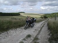
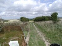
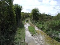
SU 544 826 to SU 550 843
Location: SU544826/SU550843
Map: Explorer 170
Date: 14/09/2005
Weather: Dry, Rain a few days ago
Difficulty: 2 - Moderate difficulty - perhaps deep ruts or large stones. Off road tyres and a bit of experience recommended.
Status: Byway
Source: OS Map
Restrictions: None
Notes: Starts off ok - wide shallow ruts, then a fairly steep chalk hill with ruts and washaway of Doom.
carcher2k
Guest
michael d said:please tell me one of those was carcher

kind regards mike
OI!!!! I seem to remember you were the only one who fell off last weekend

Cheeky git
Nice piccies Clive, when's the next one?
nadeem
Guest
so you comin' out to play tomorrow then Clive...? ")
michael d
Registered user
carcher2k said:OI!!!! I seem to remember you were the only one who fell off last weekend
Cheeky git
Nice piccies Clive, when's the next one?[/QUOTE
come on carcher its taken you a week to spot that
count me in if your organising one for a saturday ,needs a bit of rain on it to make it more of a challenge tho i think
cheers mike
carcher2k
Guest
michael d said:come on carcher its taken you a week to spot that
count me in if your organising one for a saturday ,needs a bit of rain on it to make it more of a challenge tho i think
cheers mike
yeah, my internet's been down for a while, i'm sneakily online at work at the mo

i'm busy the next few Saturday's, then it's mid Oct, and i'm not sure when the Ridgeway closes, but we may have time for a day's play before the winter sets in.
carcher2k said:and i'm not sure when the Ridgeway closes, but we may have time for a day's play before the winter sets in.
The signs have been taken down but I think certain sections are closed to traffic from 31st October.
October seems to be a busy month for me so far, but when I get my act together in working out what weekends I have spare I'll be posting a "Poll" on which day(s) people would prefer.
Clive said:The signs have been taken down but I think certain sections are closed to traffic from 31st October.
Just done a rather challenging section from SU207739 to SU231785 - that (still) has signs up restricting access from Oct 1st


SU 563 798 to SU 555 805
Location: SU563798/SU555805
Map: Explorer 170
Date: 14/09/2005
Weather: Dry, Rain a few days ago
Difficulty: 2 - Moderate difficulty - perhaps deep ruts or large stones. Off road tyres and a bit of experience recommended.
Status: Byway
Source: OS Map
Restrictions: None
Notes: Starts off ok - basic Farm track, leads past a horse paddock to a slightly rutted grass/chalk track. Just before a long steep downhill stretch there is an unlocked gate to the left leading to/through a farm eventually ending up at SU552804

Similar threads