

You are using an out of date browser. It may not display this or other websites correctly.
You should upgrade or use an alternative browser.
You should upgrade or use an alternative browser.
Tour of Berkshire Fords - Recce
- Thread starter Clive
- Start date
Noticed that the county line runs through the centre of the river, so just checked wetroads - they have it as Hampshire, which is why it wasn't on my list.
http://vamp.idlers.org/~jaffa/dp.htm?Bramshill1
http://vamp.idlers.org/~jaffa/dp.htm?Bramshill1
NeilF
Registered user
- Joined
- Sep 23, 2002
- Messages
- 1,355
- Reaction score
- 3
I used that ford one January when I was test driving the new Range Rover. The salesman was new and lived in Maidenhead, so didn't know the area. ") As we went in to the water I said "Is that marker board in feet or metres?" He went pale.
As we went in to the water I said "Is that marker board in feet or metres?" He went pale.
Good reason for maintaining a constant speed through water - if you go fast the water washes over the windscreen and you can't see the exit!

As we went in to the water I said "Is that marker board in feet or metres?" He went pale.Good reason for maintaining a constant speed through water - if you go fast the water washes over the windscreen and you can't see the exit!
Clive, I have had a dig through my old TBMs issue 26 is the one you need if you can get hold of a copy. it has a rough guide to Berkshire. it is a good route but some of it might not suite the GS. especially the railway crossing
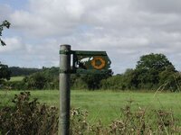
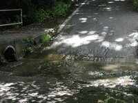
Anyway, on OS sheet 175just south of Farley Hill is the ford I mentioned it is at 753 636 but not marked as a ford!
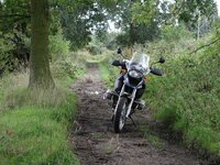
the route in TBM takes you through a concrete based ford at 743 636 in a northerly direction then 200m turn right, follow this lane turn sharp left up a hill to a tarmac road, turn right then right again follow this lane to a T turn right this leads to a much deeper rocky ford, you cannot see the exit but if you follow the river the exit will appear, once across turn right at the next T junction and you will return to the first ford.
you can do this loop on green lanes or tarmac, it is obvious on the map.
have fun
Anyway, on OS sheet 175just south of Farley Hill is the ford I mentioned it is at 753 636 but not marked as a ford!
the route in TBM takes you through a concrete based ford at 743 636 in a northerly direction then 200m turn right, follow this lane turn sharp left up a hill to a tarmac road, turn right then right again follow this lane to a T turn right this leads to a much deeper rocky ford, you cannot see the exit but if you follow the river the exit will appear, once across turn right at the next T junction and you will return to the first ford.
you can do this loop on green lanes or tarmac, it is obvious on the map.
have fun
Keith Chapman said:Anyway, on OS sheet 175just south of Farley Hill is the ford I mentioned it is at 753 636 but not marked as a ford!
the route in TBM takes you through a concrete based ford at 743 636 in a northerly direction then 200m turn right, follow this lane turn sharp left up a hill to a tarmac road, turn right then right again follow this lane to a T turn right this leads to a much deeper rocky ford, you cannot see the exit but if you follow the river the exit will appear, once across turn right at the next T junction and you will return to the first ford.
you can do this loop on green lanes or tarmac, it is obvious on the map.
have fun
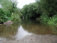
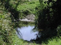
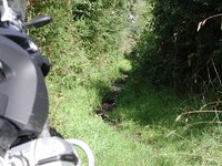
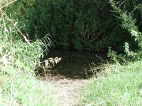
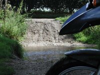
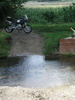
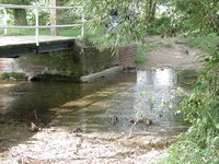
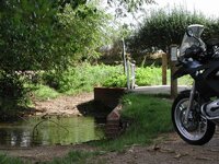
743 636 is the one I have photographed above - the 200m turn right is the byway I came down to the ford (also photo above) - the rest I can see on the map - I may need to wait until the current floods subsides a bit, unless I can bodge a good snorkel for the 1200
")
Thanks for the info.
Actually, I've just noticed there is a ford marked at the "New Mill", Eversley
I remember getting married there, but I don't remember the ford. Must have been too p*ssed
I remember getting married there, but I don't remember the ford. Must have been too p*ssed
I was married there as well, excellent place, but my interest lies more in the food, which was very good indeed, rather than in booze. I am given to understand that the booze is of a standard to match the food - my brother is an experienced drinker.
If you carry straight on past the entrance to the New Mill you will find the ford ion a few yards. Ford is quite a good depth even in dry weather, mainly due to the fact that the blackwater is fed by lots of sewage works. Not one to fall in at.
If you carry straight on past the entrance to the New Mill you will find the ford ion a few yards. Ford is quite a good depth even in dry weather, mainly due to the fact that the blackwater is fed by lots of sewage works. Not one to fall in at.
Foto John
Registered user
Excellent stuff Clive  , I'm ex of Reading (Newport Rd, just around the corner from Caversham bridge) and I still return from time to time to visit my Grand-Mother, Uncles and Aunts etc. who funnilly enough all live around Tilehurst and Calcot now.
It's definately wetted my appitite seeing those pics, though whether I'd have the bottle to ride through them on a fully freighted 1150 Adv, that I can only tip-toe with is another matter !
!
, I'm ex of Reading (Newport Rd, just around the corner from Caversham bridge) and I still return from time to time to visit my Grand-Mother, Uncles and Aunts etc. who funnilly enough all live around Tilehurst and Calcot now.It's definately wetted my appitite seeing those pics, though whether I'd have the bottle to ride through them on a fully freighted 1150 Adv, that I can only tip-toe with is another matter
!

Similar threads
- Replies
- 12
- Views
- 2,228
- Replies
- 2
- Views
- 1,683