WAAS satellite coverage In Europe

mrTickle

Registered user
Joined
Feb 6, 2003
Messages
1,055
Reaction score
0
Location
My Bikes Seat
After upgrading my GPS's firmware, I noticed that I could enable/disable WAAS. As WAAS enabled GPS units are accurate to around 3m, it should be a good thing to have it enabled.

Does anyone know if WAAS works in Europe or is it just available in North America? I believe the European equivalant of WAAS is called EGNOS, so will a WAAS enabled GPS work under EGNOS?
 
According to Garmin, WASS only works in North America.

My guess is that Garmin, being focussed on the US market, will not rush to embrace the European Space Agency's European Geostationary Navigation Overlay Service (EGNOS), nor indeed the Russian's GLONASS system.

Pan European will probably know more, but it seems to me that the system works pretty well already!

Greg
 
I have played with the WAAS. The only time I saw it working was on a beach on the welsh coast. Little 'D's appeared on the satelight bar chart and the accuracy was indeed down to 3 feet or something. Everywhere else I tried it, it did nothing.
Sea nagivation beacon or something?
Jim
 
Hi All:

I've actually been spending about 4 hours a day for the last 10 days testing SP 26xx performance with the European augmentation system.

First, let's please clean up our terminology: All of these Satellite Based Augmentation Systems (SBAS) are referred to as: Satellite Based Augmentation Systems. WAAS, or Wide Area Augmentation System, is the term that refers to the system over North America that has been sponsored by the American Federal Aviation Authority (FAA), with a little bit of money thrown in by the Canadians, to ensure coverage in Southern and mid-level Canada.

The European Space Agency (ESA) is currently in the final stages of testing a European SBAS, which will be called the European Geostationary Navigation Overlay Service (EGNOS). Some of the satellites and other components of the EGNOS system, which is scheduled for full functionality in July 2004, are being pre-tested in a system called the EGNOS System Test Bed (ESTB).

The Japanese Civil Aviation Authority also desires to set up an augmentation system to serve users in the Japanese Flight Information Region (FIR), the Japanese System will be called MTSAT [Multi-functional Transport Satellite] Satellite-Based Augmentation System (MSAS). The first rocket with a Japanese MSAS augmentation satellite on it blew up when it was launched, so the Japanese are a bit behind schedule. So Sorry.

To see a world map showing the coverage of these three SBAS, please click on this link. And, for sake of keeping the nomenclature straight, let's please all refer to these augmentation systems as SBAS, which is the proper generic name, not by the name of one of the individual systems, unless we are speaking about that specific individual system.

For those of you who would like more information about how SBAS works, there is an excellent overview (though it contains a few minor errors) at this link.

For those of you who would like more information about the European SBAS, (currently the test platform, ESTB), there is more info at this link. More information about the final form of the European System, once the test phase is finished in a month or so, can be found at this link, although it is rather technical and not written for the end user.

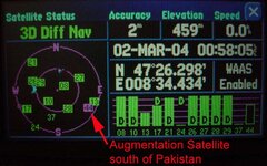
Concerning the ESTB and Garmin SP 26xx GPSR's - because the ESTB is still a test platform, it does not fully comply with all the agreed international specifications (DO-229C) for augmentation systems. This has caused some difficulty for the Garmin software engineers, who expected that the test platform would comply with the specs. At present, only the satellite over the Indian Ocean Region (satellite IOR - longitude 64 East - about south of Pakistan over the equator) is sending out a regular usable signal. This shows up as Garmin satellite number 44, though the actual licence plate on the side of the satellite is PRN 131. You can see details of the broadcast schedule of this satellite (IOR - PRN 131 - Garmin 44) at this link.

For the first time ever, I got signal strength bars today from Garmin satellite number 37 (satellite Artemis, PRN 124, located over the Republic of Congo), and Garmin satellite number 39 (satellite Indian Ocean Region West - IOR/W, PRN 126, also located over the Republic of Congo). Garmin satellite 33 (Atlantic Ocean Region East, AOR/E, PRN 120, located south of Senegal) has not been broadcasting anything lately, but because Garmin 37, 39 and 33 all broadcast almanac information for each other (but not for 44), I see the little square in the satellite map show up for 33, indicating where it should be and where the GPSR should look for it, but the GPSR never gets a signal from it. Maybe this satellite needs new batteries, who knows.

When Garmin 44 (IOR, PRN 131) is working, which has been just about every day for the last 10 days, my GPSR will note it and switch into 3D differential mode, showing an accuracy of 2 meters or so. Whether this is truthful or not we don't know, because the system is still in test. The satellites transmit a 'flag' when they are in test, telling the GPSR not to count on them for accurate signals - so the signal strength bar shows up as hollow, not solid.

If you are running 2.95b, and your GPSR has already locked onto either 37 or 39, you will see a square for 33 as well, because of the almanac rebroadcast. You probably won't see 44, which is the only functional one, because 37 and 39 are not on speaking terms with 44, but since 37 and 39 got to your GPSR first, they have told the GPSR that they (plus the non-functional 33) are the ones to look for, and not to bother looking for anything else.

Presently I am working with a later version of the SP 26xx software (not a public release) which has a work-around for this shortcoming of the ESTB - the failure of 37 and 39 to disclose the information about 44 - incorporated into it. The testing has been going pretty well, but we have to observe for a while the functionality of the test EGNOS system (ESTB) with the new algorithms in the software. Probably this will come out as a public final release in a week or so, if it can be determined that the ESTB people won't change the rules again and break the algorithm before the EGNOS system becomes functional in April.

The short answer - yes, the SP 26xx were designed right from the very beginning to work with EGNOS. The problem is that the EGNOS predecessor, ESTB, was not designed in accordance with the international specifications for SBAS. The ESA cannot be faulted for this, because they started work on the ESTB before the international standard (DO-229C) was promulgated. EGNOS itself - the final product - will comply with the world standard when it comes on line in the summer.

PanEuropean
 
Pan Euro, I'm obliged to you for that explanation.

:)

Greg

PS I wish I understood some of it - I'll get Bakerman to explain it to me the next time we meet!

:bakerman:

:stupid
 
Pan European,
You took the words right out of my............keyboard:D
John:D
I did get some of it honest.
 
Request for some beta-testing help

Hello All:

This message is addressed to those of you who have SP 2610 or 2650 GPSR's, and are using them in Europe, and who have the beta software 2.95 loaded. I'm going to ask for some help from you beta-testing the SBAS portion of this new software release.

FIRST, and this is important - back up your waypoints, routes, and track logs to your PC, using the USB cable to upload them. This is because I'm going to ask you later on to (possibly) reset your GPSR to original factory settings, which will erase the GPSR's memory of waypoints, routes and track logs - as well as individual user settings. Doing this will NOT affect the maps on the CF card (data chip), so you don't have to back up the maps (though it costs nothing to do a map backup - when you transfer maps from the GPSR to the PC, you don't actually transfer the map data, you just transfer a list of the map segment names, so it only takes 1 or 2 seconds to do this).

SECOND Put your GPSR in your car or on your moto (or get an extension cord and take it outside your house) and position the GPSR so it has a clear view of the southern sky. It is especially important to have a clear view of the south-east sky, because you will be trying to get a satellite (number 44) that is over the equator, just south of Pakistan. If you are using a mains extension cord to take the GPSR outside, be careful - I don't think the AC adapter for the GPSR has a third prong (ground outlet) in it, so don't drag the AC adapter through any puddles in your yard...

THIRD Power up the GPSR. Go to the 'satellite status' page (MENU, OPTIONS, GPS INFO) and make sure that you see the words "WAAS Enabled" or WAAS On" in the box to the right of the latitude-longitude display. If you see the words "WAAS Off", just touch the box with your finger, it should switch status (it's a flip/flop). Or, press MENU from the 'satellite status' page, and press the button 'Enable WAAS'. Now leave the GPSR running, without moving around, for about 10 minutes.

The goal is to see if the GPSR picks up satellite 44 and then switches into 3D differential mode. You can tell if it has done this because the status message above the sky map will say "3D Diff Nav" and the solid bars for the regular satellites (1 to 33) will have the letter 'D' in all or most of them. See the picture below.

FOURTH If you get 3D Diff Nav, great, the test is complete, no further work needed, please post your success story below (brief - just a line or two). If you don't succeed in getting 3D Diff Nav after 10 minutes or so, check to see if you are getting good reception on any normal satellite (1 through 33) that is located about halfway along a straight line drawn between the letter S (for south) and the letter E (for east) on the satellite map. This check is to make sure your view of the south-east sky is not blocked. If you don't see any normal satellites in that quadrant, move to a new location and begin step three again. If you do see normal satellites in that quadrant, but you are not getting good reception (a hollow signal strength bar) on satellite 44, go to step five.

FIFTH OK. You DID backup your waypoints, routes, and tracks to your PC, right? Now, please reset your GPSR to its factory default settings. To do this, begin with the power turned off, and press in and hold the PAGE and MENU keys, while keeping a finger gently pressed in the lower right corner of the touch-screen. Now turn the power switch on (with your third hand) and continue to hold the PAGE and MENU keys (on the GPSR, not the remote) in, while keeping your finger in the lower right corner of the screen. You will get a message asking if you want to delete all user data (at this point you can let go of the buttons and the screen) please answer "YES".

When it reboots, it won't know where it is, and it will take a few minutes to collect almanac data from the satellites. Go to step three and start over again, this time, hopefully, it will notice satellite 44 and switch into 3D Diff Nav mode. Please post a message here letting me know if this does or does not happen for you.

Note that it is generally not a good idea to reset the GPSR to factory defaults unless you have a reason to do so. In other words, don't do it every day. But, if you are trying out beta software (such as 2.95), doing a factory reset after loading the beta software is usually the best way to ensure that you have 'neutral' user preference settings, which means you have the best opportunity to see the beta software perform in the way that the engineers hoped it would.

I thank you in advance for your help, and for posting your results here on this thread.

PanEuropean
 
What the augmentation satellite looks like, and where it appears (with GPSR in Switzerland)
 

Attachments

  • augmentation.jpg
    augmentation.jpg
    70.9 KB · Views: 829
You really started something there MrTickle, I read it all twice and my head is still spinning!
On a slightly different note, I have tried to PM you and your mailbox is full. john.:confused:
 
2610 on ebay

Its still unresolved at present, I am waiting for a Europe CN package. Will probably be selling the 2610, with Europe/US software, keeping the SPIII for now, will post an update on original thread when I know for certain. john.
 
Re: 2610 on ebay

GADGET said:
Its still unresolved at present, I am waiting for a Europe CN package. Will probably be selling the 2610, with Europe/US software, keeping the SPIII for now, will post an update on original thread when I know for certain. john.

John

Be careful that he's not just stringing you out. Once you pass the 30 day time limit to lodge a claim you're stuffed - neither eBay nor PayPal will be interested. This is a known scam technique apparently. To make things worse they only cover up to £250 anyway.

Personally I'd go down the credit card refund route and sooner rather than later.

Adam :beerjug:
 
Re: Re: 2610 on ebay

adamski49 said:
John
Personally I'd go down the credit card refund route and sooner rather than later. Adam :beerjug:
I agree with Adam, you can put your card in dispute, and then withdraw it later if need be.
John
 
Have already done the right thing with ebay/paypal and credit card company, the CN EuroV6 is `in the post `so will not have long to wait/ find out if OK, I am confident, the other 3 `buyers` who received nought have received refunds, interestingly the seller has advertising currently on ebay, 2610 with both USA/Euro software, no 1gb card. For £849!!! :rolleyes:


Back
Top Bottom