BigAlMacMac
Registered user
So having passed my test in October and had a rush of blood buying an 04 1200 GS in November I just had to get some miles under my belt. Why not the Scottish Coastline, including all penisulas but not dead ends. Starting on the North bank of the Clyde and finishing on the north bank of the Forth
Ok so having mentally defined the criteria, it actually is a little harder, once the map comes out, especially other that the West Coast of Scotland. And of course does the Mull of Kintyre count as a dead end or a loop using the Cambeltown road down and the Skipness road back.
So in the end I decided I wanted to get onto roads I actually had not been on before which was North of Lochinver all around the top, to Inverness then along to Fraserburgh and down to Stonehaven.
Day 1: Fintry (near Stirling) - Crianlarich - Fort William - Loch Carron - Applecross - Torridon - Poolewe - Ullapool
Started about 8 finished about 5- 310 Miles. GPS Drive Average 43 MPH
A real slow start because of overnight frost and no experience of handling frosty country roads (advise wanted here) so just rode very slowly. The day was cloud free but very cold. I had my heated grips on full, most of the time and was happy indeed to have so many layers on.
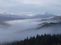
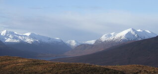
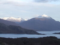
With the previous weeks snow on the hills and clear blue skies the views were fantastic. Particularly memorable was the drive over the Bealach na Ba to Applecross, a mad mini Alpine pass with switchbacks on single track. The road from Applecross was fantastic quality although still single track and with the sea next to you, Skye in the distance and Raasay in the foreground was the best drive of all. Just as you think it can't get better you round a corner with jaw dropping views of the mountains of Torridon.
Beyond Torridon the singletrack dissapears for a while allowing the beast to stretch its legs on deserted roads. Eye watering performance is all I can say...
Dusk set in then the darks as I finally pulled in to Ullapool.
Day 2: Ullapool, Stac Pollidh Road to Lochinver, Assynt Penisula to Stoer, Durness, Dunnet Head, John O Groats, Helmsdale.
Started 8:30 finished around 5:30 254 miles GPS Driving Average 37 MPH
Another fantastic day, with the forecast to deterioate quickly, though the strong winds and rain heading North so due to hit around lunchtime.
The minor road to Lochinver was fantastic combining high moor, mountain, sea and loch scenery. About 10 miles south of Lochinver the road gets slightly hairy as there is a choice of a cliff on oneside of the road or a wall leading to a drop into the sea on the other. This is combined with tight turns and no visibility around the corners.
North of Lochinver the tiny settlements seem to become untidy and unkempt looking, especially around Clachtoll but Clashnessie Bays picks things up again.
What a relief to join a major road at Kylesku bridge though frustrating that the sign said Ullapool 40 miles or something and I had left there about 2 and a half hours ago.
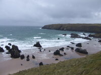
A mix of blasting and reasonably fast single track through increasing strong wind brought me to very gust Durness. I was frustrated at not being able to get to Cape Wrath, the Most North Westerly part of the mainland, especially since my 6210 said you could. A couple of photos next to the wild crashing waves on Duness beach and off along the North Scottish coast line. I had only average 22 miles per hour all day so was hoping for some faster roads ahead.
It was rather sirprising how the land changed quite suddenly from Scottish Highland type moutain and moor to agricultural and rolling. Somewhere around Bettyhill I think.
As I started to get closer to Dounrey I kept looking for prosperous villages benefiting from the Nuclear Knowledge workers salaries but nothing at all. Not until I came over the hill and saw Thurso. After all the remote communites I had ridden through this was positively huge. I stalled my bike in the middle of town having forgotten what to do with my clutch at traffic lights!
Stalling apart, I shot through the megopolis of Thurso headed for the most Northely point on the mainland, Dunnet head. It was really windy now with the wind alternating between trying to wrench the helmet off my head or just throwing me off the bike. The bike itself always remaing predictable and just needed some leaning into the wind, though not always guessable which way, at times.
Dunnet Head was as bleak and windy as you could imagine. I took a wee video but you can't hear a thing I say, such is the noise. The lighthouse was closed so I just peered through the murk in the direction of Orkney. Looking further east a long the coast at John o Groats I could see a wild rain shower.
And so it was. Not a soul there. Just wind, lashing with rain and the Disney Horror movie Hotel that is the John o Groats hotel. All in all very grim. I couldn't even find a sign that pointed to Land's End, so many hundreds of miles away.
Is it always the case that places that are well know are just plain non entities or is John O Groats not at its best in a November storm?
With less than half my required milage done and the plan to be home tomorrow I decided to ride through the rain, wind and oncoming dark as far as I could. The roads really improved south of Wick as I was on the A now but my lack of experience in these kind of conditions meant I could not really decide between visor up and seeing better, albeit with rain regularly in my eyes or visor down but light scattering from oncoming headlights. I just rode slower and slower until at one point I let a truck pass me. I figured I would stop at the next place.
And so it was I discovered Helmsdale and a rather nice Hotel, unless you are against shooting as its walls were covered by around 100 heads or horns or stuffed fish or fowl. A great meal but best of all a long soak in the bath with a pint.
Day 3: Helmsdale: Inverness: Lossiemouth: Fraserburgh: Ellon
9 am to 3pm about 200 miles GPS driving average 45 MPH
The rain lashed the hotel windows as I drifted of to sleep so I was stunned by the great start to the day. Clear skies and much less wind. The next problem was how to cope with heading south straight into the low winter sun. Ah, but we are never happy! So needing to get home today I decided to miss out some of my side road trips to Dornoch, Portmahummock and Cromarty (anyone know if a ferry runs between there and Nigg, my GPS thinks so!).
The road to Inverness sticks pretty close to the sea so unlike much of this route the sea is just there. Skirting Inverness took me along another new road for me, this time heading more or less straight to Fraserburgh. I decided to stop off at Lossiemouth for a sausage roll lunch on the beach as the Tornados defeaned me taking off from the nearby RAF base. Seemed like a nice spot for a kids holiday.
The main road I was on was the A98 which was rather busy but let me become more confident with overtaking loads of traffic. Most of my overtakes were rapid in 4th gear but in one overtake I didn't realise I was in third. I pulled back the throttle and felt my eyballs pressing the back of my skull as the GS headed for the horizon. I couldn't decide if the feeling was elation or fear but it put a big smile on my face.
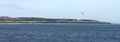
Once in Fraserburgh I headed to the lighthouse and a wee drive around the harbour, with the largest fishing boats I have seen in Scotland, ships really. I don't know if I was unlucky but I couldn't really see any reason to hang around Fraserburgh (no offence meant).
I was now in a quandary, it was about 2pm and I really needed to get home but I also wanted to go around the coast and also drop in on my cousin who lives near Ellon. I decided on the later for a quick coffee and called the wife only to be surprised that she suggested I stay. What elation. My bum was numb and my shoulders increasingly stiff. It was fantastic to break open the wine and just chill out.
Day 4: Ellon to Fintry via Dundee and Perth
8:30 to 11: 15 - 153 miles- GPS driving average 55mph
A rapid journey only really slowed by Aberdeen City Centre, Dundee and the annoying average speed cameras on the Dundee Perth road (they only point forward so kept thinking they couldn't time a bike, but decided to take it easy anyway)
Lessons Learned.
300 miles a day on Scottish single track is hard going on the bum and the shoulders
I only saw 3 other bikes all barr one in a city. Does noone go out on their bike in November?
I need to learn how to cope with frosty roads, testing the grip etc
I could probably do with a heated vest and couldn't have gone without the heated grips
Everywhere is closed
There are no cars. I didn't count but I think from Fortwilliam until the Outskirts of Thurso there was no more than 30 cars. The most common was a 4 by 4 pulling a sheep trailer.
The 1200 GS is brilliant though I will need to look into getting a seat capable of 8 hours riding a day.
And I need to figure out how to add photos to this post to show the views!
Cheers
Alan
Ok so having mentally defined the criteria, it actually is a little harder, once the map comes out, especially other that the West Coast of Scotland. And of course does the Mull of Kintyre count as a dead end or a loop using the Cambeltown road down and the Skipness road back.
So in the end I decided I wanted to get onto roads I actually had not been on before which was North of Lochinver all around the top, to Inverness then along to Fraserburgh and down to Stonehaven.
Day 1: Fintry (near Stirling) - Crianlarich - Fort William - Loch Carron - Applecross - Torridon - Poolewe - Ullapool
Started about 8 finished about 5- 310 Miles. GPS Drive Average 43 MPH
A real slow start because of overnight frost and no experience of handling frosty country roads (advise wanted here) so just rode very slowly. The day was cloud free but very cold. I had my heated grips on full, most of the time and was happy indeed to have so many layers on.
With the previous weeks snow on the hills and clear blue skies the views were fantastic. Particularly memorable was the drive over the Bealach na Ba to Applecross, a mad mini Alpine pass with switchbacks on single track. The road from Applecross was fantastic quality although still single track and with the sea next to you, Skye in the distance and Raasay in the foreground was the best drive of all. Just as you think it can't get better you round a corner with jaw dropping views of the mountains of Torridon.
Beyond Torridon the singletrack dissapears for a while allowing the beast to stretch its legs on deserted roads. Eye watering performance is all I can say...
Dusk set in then the darks as I finally pulled in to Ullapool.
Day 2: Ullapool, Stac Pollidh Road to Lochinver, Assynt Penisula to Stoer, Durness, Dunnet Head, John O Groats, Helmsdale.
Started 8:30 finished around 5:30 254 miles GPS Driving Average 37 MPH
Another fantastic day, with the forecast to deterioate quickly, though the strong winds and rain heading North so due to hit around lunchtime.
The minor road to Lochinver was fantastic combining high moor, mountain, sea and loch scenery. About 10 miles south of Lochinver the road gets slightly hairy as there is a choice of a cliff on oneside of the road or a wall leading to a drop into the sea on the other. This is combined with tight turns and no visibility around the corners.
North of Lochinver the tiny settlements seem to become untidy and unkempt looking, especially around Clachtoll but Clashnessie Bays picks things up again.
What a relief to join a major road at Kylesku bridge though frustrating that the sign said Ullapool 40 miles or something and I had left there about 2 and a half hours ago.
A mix of blasting and reasonably fast single track through increasing strong wind brought me to very gust Durness. I was frustrated at not being able to get to Cape Wrath, the Most North Westerly part of the mainland, especially since my 6210 said you could. A couple of photos next to the wild crashing waves on Duness beach and off along the North Scottish coast line. I had only average 22 miles per hour all day so was hoping for some faster roads ahead.
It was rather sirprising how the land changed quite suddenly from Scottish Highland type moutain and moor to agricultural and rolling. Somewhere around Bettyhill I think.
As I started to get closer to Dounrey I kept looking for prosperous villages benefiting from the Nuclear Knowledge workers salaries but nothing at all. Not until I came over the hill and saw Thurso. After all the remote communites I had ridden through this was positively huge. I stalled my bike in the middle of town having forgotten what to do with my clutch at traffic lights!
Stalling apart, I shot through the megopolis of Thurso headed for the most Northely point on the mainland, Dunnet head. It was really windy now with the wind alternating between trying to wrench the helmet off my head or just throwing me off the bike. The bike itself always remaing predictable and just needed some leaning into the wind, though not always guessable which way, at times.
Dunnet Head was as bleak and windy as you could imagine. I took a wee video but you can't hear a thing I say, such is the noise. The lighthouse was closed so I just peered through the murk in the direction of Orkney. Looking further east a long the coast at John o Groats I could see a wild rain shower.
And so it was. Not a soul there. Just wind, lashing with rain and the Disney Horror movie Hotel that is the John o Groats hotel. All in all very grim. I couldn't even find a sign that pointed to Land's End, so many hundreds of miles away.
Is it always the case that places that are well know are just plain non entities or is John O Groats not at its best in a November storm?
With less than half my required milage done and the plan to be home tomorrow I decided to ride through the rain, wind and oncoming dark as far as I could. The roads really improved south of Wick as I was on the A now but my lack of experience in these kind of conditions meant I could not really decide between visor up and seeing better, albeit with rain regularly in my eyes or visor down but light scattering from oncoming headlights. I just rode slower and slower until at one point I let a truck pass me. I figured I would stop at the next place.
And so it was I discovered Helmsdale and a rather nice Hotel, unless you are against shooting as its walls were covered by around 100 heads or horns or stuffed fish or fowl. A great meal but best of all a long soak in the bath with a pint.
Day 3: Helmsdale: Inverness: Lossiemouth: Fraserburgh: Ellon
9 am to 3pm about 200 miles GPS driving average 45 MPH
The rain lashed the hotel windows as I drifted of to sleep so I was stunned by the great start to the day. Clear skies and much less wind. The next problem was how to cope with heading south straight into the low winter sun. Ah, but we are never happy! So needing to get home today I decided to miss out some of my side road trips to Dornoch, Portmahummock and Cromarty (anyone know if a ferry runs between there and Nigg, my GPS thinks so!).
The road to Inverness sticks pretty close to the sea so unlike much of this route the sea is just there. Skirting Inverness took me along another new road for me, this time heading more or less straight to Fraserburgh. I decided to stop off at Lossiemouth for a sausage roll lunch on the beach as the Tornados defeaned me taking off from the nearby RAF base. Seemed like a nice spot for a kids holiday.
The main road I was on was the A98 which was rather busy but let me become more confident with overtaking loads of traffic. Most of my overtakes were rapid in 4th gear but in one overtake I didn't realise I was in third. I pulled back the throttle and felt my eyballs pressing the back of my skull as the GS headed for the horizon. I couldn't decide if the feeling was elation or fear but it put a big smile on my face.
Once in Fraserburgh I headed to the lighthouse and a wee drive around the harbour, with the largest fishing boats I have seen in Scotland, ships really. I don't know if I was unlucky but I couldn't really see any reason to hang around Fraserburgh (no offence meant).
I was now in a quandary, it was about 2pm and I really needed to get home but I also wanted to go around the coast and also drop in on my cousin who lives near Ellon. I decided on the later for a quick coffee and called the wife only to be surprised that she suggested I stay. What elation. My bum was numb and my shoulders increasingly stiff. It was fantastic to break open the wine and just chill out.
Day 4: Ellon to Fintry via Dundee and Perth
8:30 to 11: 15 - 153 miles- GPS driving average 55mph
A rapid journey only really slowed by Aberdeen City Centre, Dundee and the annoying average speed cameras on the Dundee Perth road (they only point forward so kept thinking they couldn't time a bike, but decided to take it easy anyway)
Lessons Learned.
300 miles a day on Scottish single track is hard going on the bum and the shoulders
I only saw 3 other bikes all barr one in a city. Does noone go out on their bike in November?
I need to learn how to cope with frosty roads, testing the grip etc
I could probably do with a heated vest and couldn't have gone without the heated grips
Everywhere is closed
There are no cars. I didn't count but I think from Fortwilliam until the Outskirts of Thurso there was no more than 30 cars. The most common was a 4 by 4 pulling a sheep trailer.
The 1200 GS is brilliant though I will need to look into getting a seat capable of 8 hours riding a day.
And I need to figure out how to add photos to this post to show the views!
Cheers
Alan

 It's a fabulous trip but I take my hat off you for carrying it out with little more than a month's experience under your belt. Check out the ride report and photos of Region 9 of the Pink Way Round.
 so have a look at this