Aftermath of "A Weekend of GS Trail Riding 9th & 10th June 2007"

Great ride report, looks like you lot had good fun. Only problem is I now have to do some work to catch up from reading all of this...
 
HUNTING FOR RED OCTOBER

My mate Mick left Bordon at 5pm and arrived at Aylesbury on time theDRZ then ran out of fuel, Mick would not be towed to the petrol station so pushed it 1/4 of a mile, bimbled to Chippers and rang Clive who had left Stow, meet at ford but gone tried hunting a for a few more grids then agreed to call it day, had a fry up in Cirencester and then took some lanes heading back east.
It would have been nice to be waited for but this obviously was not going to happen which i have to admit i dont grasp and mick who had sorted us out with a pitch and free taxi to the pub last time thought was very odd- what could i say to him - not a lot.
 
It would have been nice to be waited for but this obviously was not going to happen which i have to admit i dont grasp and mick who had sorted us out with a pitch and free taxi to the pub last time thought was very odd- what could i say to him - not a lot.
Just so you don't think I am a complete b*stard :D , I've been through the track log and my sent texts...

Left the garage at Stow 10 minutes "late" at 10:10

We spoke on the mobile about 10:15 when you were in Chipping Norton and arranged to meet at waypoint 007 Kineton Ford, which is about 20 mins from Chipping Norton.

Got to Kineton Ford at 10:40

Sent you a text to say try meeting at waypoint 012 and left after waiting 15 minutes at 10:55

Got to waypoint 012 at 11:08 - waited 5 minutes and realised the previous text didn't send. We spoke on Simon's mobile (as I still didn't have a signal) to say try meeting at waypoint 018

Got to waypoint 018 at 11:37

Waited 10 minutes and we decided you didn't have working GPS with waypoints on or a map so were unlikely to find any of the waypoints.

At 11:48 sent you a text to say meet at garage at Andersford at 12:15 and we would wait there until 12:30. Andersford garage was where I was told you had been before for petrol so would probably know where that was without map.

Got to Andersford about 12:05

Waited 25 minutes until 12:30 - then sent you a text to say meet at Culkerton at 13:15 - unfortunately we didn't get there until 14:30 but I think by then I'd already had a text from you saying you were in Cirencester.

I did mention on the original thread that I didn't have any planned stops, so was hoping you would have maps/waypoints/coords and could "get ahead of us".

I had 8 other people to consider hanging around in the heat and a campsite to try and get to by 3pm(ish) - what more could I have done :nenau

Anyway, now I have the track log, I'll have a better idea of the timing and build in some "planned stops" for the next time :beerjug:
 
bum wiping

make no mistake we had quite a few problems but If as much effort was put into checking your phone and text logs as was put into getting us together we might have met up. Then you could have wiped our bums for the rest of the day!
 
guided tour

£175 for a weekend? is that a special rate for people with big bikes, most of the ones i know charge £25a head per day
 
Clive I wasn`t there, sorry, I would have loved to have been, Friday I went out got my AIRHEAD M.O.T`ed and taxed and new TK80`s fitted, and was going to join.

But Mrs Baps very very rarely says anything but after a week at THE T.T Races the garden and a visit too my mother was mentioned, so I did so.

As both of us are event organisers, but yours is FREE, THANK YOU for giving me the chance, but sorry I just couldn`t make it.

Bakes
 
Bakerman, it was an absolutely great day out, one of the best Ive had as a relative novice with a bunch of great blokes and one lady.

Thanks again to Clive and great pics Pumpy. Any sign of Jarv? ;)
 
REM - did you do that manually or are you able to import the tracklog straight into Google maps. Would be interested to know, it's a really good way to view a route.

errm not quite straight into Google Maps.

First you have to create a kml file from the GPS log. I converted Nins track log (gdb file) using GPSbabel into a text file listing the points in order travelled. I used a sample kml file and pasted the lon/lat positions into the relevant section. (there must be a direct converter from GPS to kml somewhere)

At this stage you can load the kml into Google Earth and get the same result only not so easy to share it.

To load into Googel Maps you first have to have a web hosting site. You can probably use your SIP provider - Could we use UKGSER ????. I opened a Googlemail account which included some web space Googlepages. I uploaded the kml file to this space and made a note of the URL.

In Googel Maps, paste the URL for the kml file into the Search Maps box. This loads the route in the map view. Then click "link to the page" which places the complete URL for the location that you are viewing and the data loaded into your Browser address bar. Then paste or send this URL to whereever and whoever.

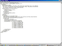
This if the kml file with just an extract of the list of coordinates that make up the actual route. You can change the name, descriptions, colours and a whole load of other features some of which only work in Google Earth. I have not got my head around them all yet:


<?xml version="1.0" encoding="UTF-8"?>
<kml xmlns="http://earth.google.com/kml/2.1">
<Document>
<name>Paths</name>
<description>Examples of paths. Note that the tessellate tag is by default
set to 0. If you want to create tessellated lines, they must be authored
(or edited) directly in KML.</description>
<Style id="yellowLineGreenPoly">
<LineStyle>
<color>7f00ffff</color>
<width>4</width>
</LineStyle>
<PolyStyle>
<color>7f00ff00</color>
</PolyStyle>
</Style>
<Placemark>
<name>Absolute Extruded</name>
<description>Transparent green wall with yellow outlines</description>
<styleUrl>#yellowLineGreenPoly</styleUrl>
<LineString>
<extrude>1</extrude>
<tessellate>1</tessellate>
<altitudeMode>relative</altitudeMode>
<coordinates> -1.725776,51.927888,300
-1.725433,51.927953,300
-1.725411,51.928082,300
-1.72539,51.928146,300
-1.725261,51.928661,300
-1.725068,51.92924,300
-1.725261,51.929455,300
-1.727214,51.929905,300
-1.729016,51.930442,300
-1.729424,51.930506,300
-1.731441,51.930635,300
-1.732879,51.930399
-1.73599,51.92997
-1.739273,51.929884
-1.739509,51.929862
2.230439,51.514957
-2.230461,51.514957
</coordinates>
</LineString>
</Placemark>
</Document>
</kml>


When I first tried this I just used the lon/lat values and nothing appeared. I then added some altitude values but not for all the points, and bizarely it worked.

I think you can include placemarkers with images so we could publish the route with photos at the locations where they were shot.

Lots of potential, but we were lucky on this route that the aerial imagery is quite good, although the map background is still useful.
 
Oops - you cant paste xml into theses posting... kml sample file below. Also if you click KML above the map window in Google Maps it gives you the full code.
 

Attachments

  • kml.jpeg
    kml.jpeg
    58.4 KB · Views: 148
Great weekend

Clive,

thanks very much for organising the weekend it was great fund even though I nearly killed myself... hmmm!

Anyway, apologies for the delay in getting the photo's uploaded but it's been a busy week.

Simon (jarv)

http://www.flickr.com/photos/9012334@N08/sets/72157600364181407/

551801845_869917eb99_b.jpg

551801905_3bdeb2479d_b.jpg

551801947_e14f00334f_b.jpg

551801959_cecd33e59e_b.jpg
 
What a fantastic weekend you guys had!! Well done Clive :clap :thumb2

Unfortunately I was at the Isle of Wight festival for this one, so couldn't make it. Hope to be there for the next one though :aidan
 
errm not quite straight into Google Maps.........

REM - thanks very much for the time you must have invested in explaining that. Clearly not quite as straightforward as I had hoped or anticipated but very interesting none the less.

Suspect it's a bit beyond me at this stage but I'll continue trying to learn and understand how this technology can be used to achieve some fantastic and very useful results.

Thanks again !:bow


Back
Top Bottom