GPX - M’off - Hurtgen Forest

At the top, there is a notice board telling that the hilltop site used to host a Medieval castle, it’s strategic value, long recognised:

IMG_0480.jpeg

The site certainly commands big views. The wooden bench ‘sun lounger’ stands atop a large bunker:

IMG_0472.jpegIMG_0471.jpeg

The hilltop also now boasts an observation tower (I thought I had a picture if it) accessed via a spiral staircase. The views from atop of it are good:

IMG_0491.jpeg

 
Last edited:
Hill 400 behind me, I had planned to visit the German cemetery at Hurtgen village:

IMG_1326.jpeg

Unfortunately, the cemetery was closed for maintenance, though the information boards were reasonably interesting:

IMG_0498.jpegIMG_0499.jpeg
IMG_0494.jpegIMG_0495.jpegIMG_0496.jpeg

The village of Vossenack and its cemetery will be my next stop, as I start to curl my way back to my hotel at Simmerath.
 
Last edited:
Day three continued…..

The next destination is the village of Vossenack.

The village sits on the crest of hill, from which descends the former pilgrims’ path (The Kall Trail)down the valley, across the Kall stream and up the other side to the village of Schmidt:

IMG_1319.jpeg


The classic shot of Vossenack church today:

IMG_0500.jpeg


and how it looked in the winter of 1944:

IMG_1318.webp

I’ll be coming back to the village to see the museum, which is only open on Sundays.

To be continued…..
 
Last edited:
Besides there being no old houses, one more thing struck me, when reading the book (I’d highly recommend it). The villages have all grown since 1944. In the book, the villages of Vossenack and Germeter are separate and distinct from one another, fought over separately. Now they are conjoined into one. Likewise the town of Simmerath, where I was staying, was separate from Kesternich and subject to separate battles, especially when the Americans attacked towards the dams, late on in the battle. I walked from Simmerath into Kesternich, without realising I had left the former and moved into the latter.

IMG_1327.jpeg
 
Day three continued….

Vossenack’s roadworks worked out, ahead of my visit on Sunday to the museum, I pressed on to Vossenack’s German cemetery.

IMG_0509.jpeg

Again, there are good explanation boards:

IMG_0509.jpegIMG_0512.jpegIMG_0517.jpegIMG_0518.jpegIMG_0519.jpegIMG_0520.jpegIMG_0521.jpegIMG_0522.jpegIMG_0523.jpegIMG_0524.jpeg

The graves of the Jacobs’ family father and his three children, mentioned above:

IMG_0531.jpegIMG_0530.jpeg

And that of Model. Model’s grave marker is unusual in that it is cemented in, level with the surrounding concrete. I can only assume this is because it makes it more difficult to steal:

IMG_0533.jpeg
 
Last edited:
A view into the cemetery, which lies on a gentle slope:

IMG_0526.jpeg

and a view looking back towards the entry gate, with the information boards to the right:

IMG_0534.jpeg


The ‘Remember those that perished in the East’ stone, mentioned above:

IMG_0535.jpeg
 
Continuing my ride down to my hotel, I detoured slightly to pass through the village of Simonskall:

IMG_1328.jpeg

The village lies in a valley, with the small Kall river running behind it. The village has a useful map, showing the footpaths and position of German bunkers, which litter the area:

IMG_0545.jpeg


It hosts what was a German hospital bunker, built into the ground floor of what is now a house. The hospital bunker has now been restored by the museum in Vossenack; open on the first Sunday of the month:

IMG_0543.jpegIMG_0542.jpeg

Very few houses remain of the villages and towns from before the battle of the Hurtgen Forest. One that does, is the tall white building, dating I believe from 16th century:

IMG_0541.jpeg

When I visited the museum, they explained to me how the building survived, when the rest of the village was destroyed. Simonskaller, lies in a valley. The American artillery could not easily target the left side of the village street, only the right. A twenty foot chance of war, meant the rare building’s survival.

 
Last edited:
My final call was to see another of the ‘Liberation Route Europe’ listening posts, this one in the village of Rott, which served as the HQ for the American battalions fighting in the forest.

The iPhone generated map of the place is perhaps interesting as it shows the Hurtgen Forest’s proximity to Aachen (the first city in Germany to fall to the Allies) and to the Belgian Ardennes:

IMG_1329.jpeg

The listening post:

IMG_0565.jpegIMG_0566.jpeg


Besides the listening post, the village has some passably interesting bronzes:

IMG_0562.jpegIMG_0564.jpeg

IMG_0559.jpeg
IMG_0560.jpeg
IMG_0561.jpeg

From Rott, it’s a short run back to my hotel in Simmerath.

Day three complete, day four to follow…….
 
Last edited:
Enjoying this, thanks! The Model grave is interesting, given post war attitudes to suicide and the efforts made to dissociate from the Nazi era in the immediate aftermath of the war. As an aside, my mother in law is distantly related to a prominent member of the Nazi party (No punchline on this one, believe it or not!) who is buried in Berchtesgaden. We found his gravestone some years ago and were told that it is kept immaculately clean and tidy and fresh flowers are still laid several times each year. By whom, we have no idea.
 
Great write-up. A mental note to visit the area...

Thank you. It’s not far across from Calais or the North Sea ports.

It’s really just a very small part of the whole Eifel / Belgian Ardennes / North Luxembourg area.

IMG_1330.jpeg

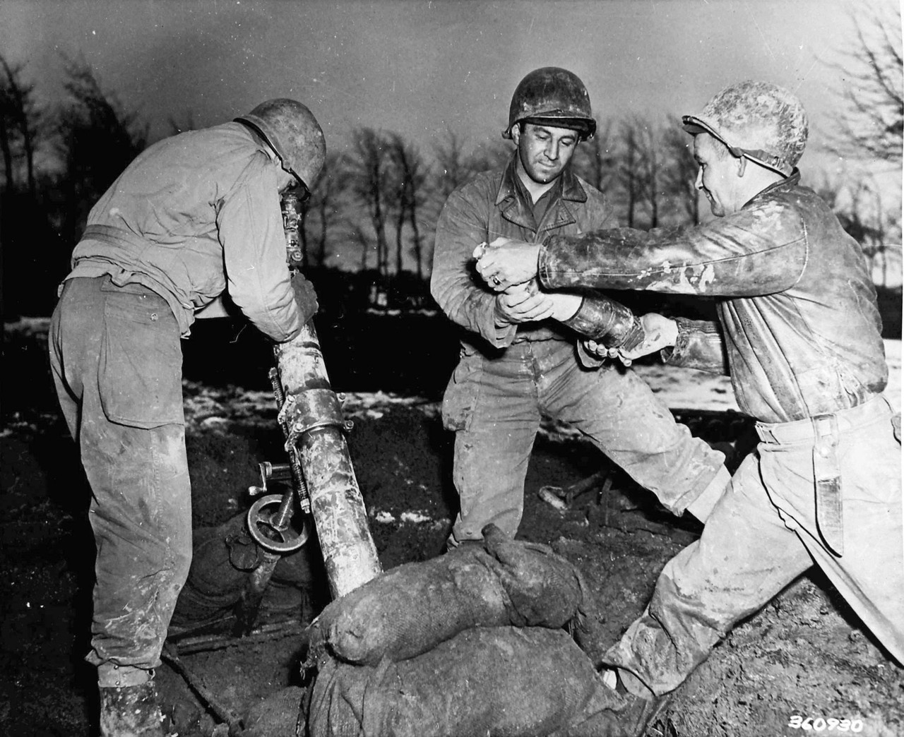
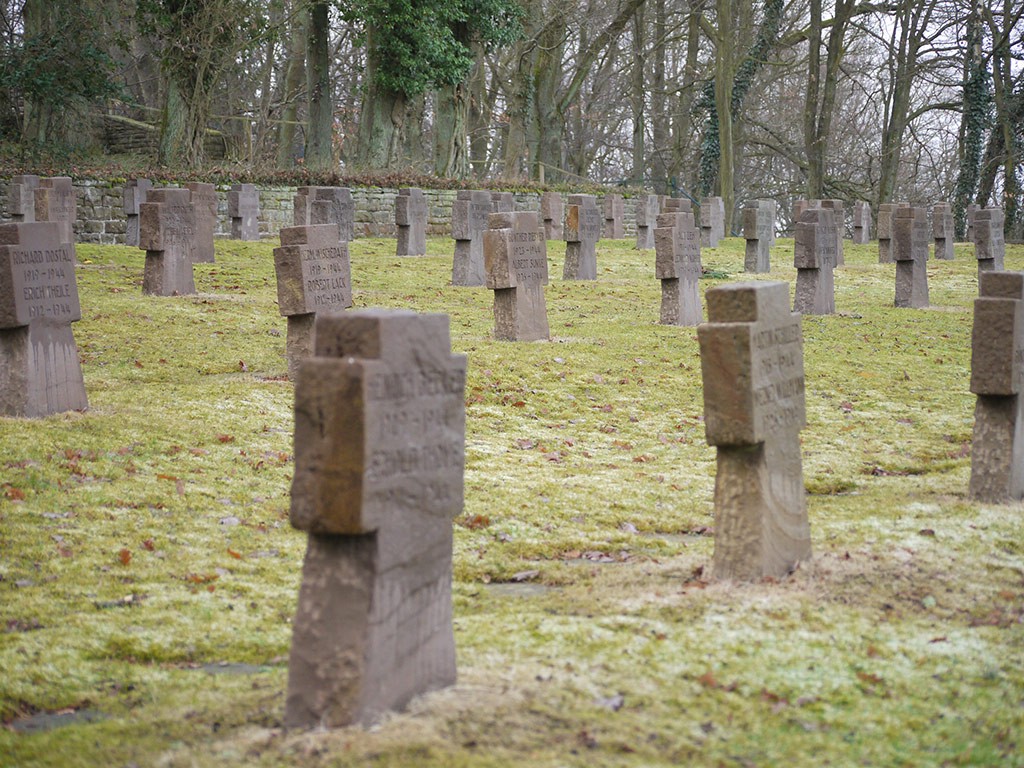
Indeed, it’s the compact smallness of the densely wooded, steeply banked area of just 50 square miles, that makes the series of attritional battles that roared across it for months on end so terrible. Yet it’s all but unknown, overshadowed by Arnhem and the Battle of the Bulge. It was an absolute disaster for the American army group and, not least, the men thrown into it.

Interesting (or not) the map above shows the town of Stolberg, just to the east of Aachen. As can be seen, it is bordered to the immediate south by the Eifel / Hurtgen forest. It is relativity flat land, leading directly to Düren, the larger town and the gateway to the plain before the Rhine river. It is a part of the so called, ‘Stolberg Corridor’. This is important as historians and military experts alike have pointed out that the corridor would have allowed the Americans to have bypassed the Hurtgen Forest entirely.

Whilst undoubtedly true, it is tempered very slightly by the fact that the Americans had overrun their supply lines, in the 90 day rush from the breakout from Normandy, Antwerp (and its deep water port / estuary) not yet having been seized, which was Montgomery’s failing. American supplies still had to come all the way from the D-day beaches, miles to the west. Similarly, the American generals, feared a flanking attack from the south / forests, leaving them vulnerable. History though (and simple) military fact does not render these problems a good enough excuse for what happened in the Hurtgen. Indeed, it made no military sense to the Germans who were amazed that the Americans even considered the venture, let alone start it and continue for months of slaughter.

I would like to go back at some point, if only to tick off the places I didn’t see. These include: Düren, the hospital bunker at Simonskall, the building which housed Major General Cota (who oversaw the blood letting) and the village of Roetgen, the first village in Germany to fall into allied hands and, (not least) walk the final section of the Kall Trail, from the bridge up the hill to the town of Schmidt. Will I then have seen it all? Well, I’d have seen lots of the main sites. To see more, would mean dedicating myself to individual battles within the four months it took the Americans to break through the forest to the dams. Whilst I like identifying and standing at (or close to) specific spots ‘Where something happened’, I guess to ‘Do it all’ would take a couple of weeks or more. I think I’d be content with the bits I’d seen. Not least, I want to go to see the sites to the east and south of Berlin, which brought about the fall of the capital to the Russians.

PS One hopefully vaguely interesting aside. Every time you pick up a bottle of Heinz tomato ketchup, you can be reminded specifically of the American army’s 28th Infantry Division, that was decimated in the forest:

IMG_1331.jpeg
 
Last edited:
Day four


Pea soup, a (failed) visit for pudding, a wedding, the fire brigade and a walk in the forests.

To be continued…..


PS If anyone is wondering why I backtracked at point 7, instead of carrying up the excellent L249 to Heimbach, it was because the road was most definitely closed for major roadworks, just past the monastery (lunch stop) at point 7.

IMG_1333.jpeg
 
Last edited:
Day four… continued…

I was up and about early, as I needed to buy a new cable lock, used to hold my helmet / jacket to my motorcycle when I stop at a cafe. I had somehow contrived to lose mine earlier on the jaunt. Thinking that Abus (whose lock I’d lost) is a German brand and that a bicycle shop was more than likely to sell them, I Googled ‘Bicycle shop near me’. Up popped three, all in Simmerath, where I was staying. I chose the largest and strolled around at 10:00 when the shop opened. Happy days. The lady owner gave me a discount, so I bought two.

IMG_4858.jpeg

IMG_4859.jpeg

Bicycle cable locks aside, my plan for the day involved:

A. Returning to the monastery and having their pea soup for lunch.

B. Trundling up to Hausen for a pudding of cherry Windbeutel.

C. Seeing the remains of some bunkers and a memorial, in the woods and forest close to Simonskall.

Recommendations as to A and B were kindly provided to me by Paul08 as a part of this thread:

Post in thread 'M’off…… Hurtgen Forest….. August'
https://www.ukgser.com/community/threads/m’off……-hurtgen-forest…-august.486810/post-5883370

Post in thread 'M’off…… Hurtgen Forest….. August'
https://www.ukgser.com/community/threads/m’off……-hurtgen-forest…-august.486810/post-5883374

What is or are Windbeutel?

 
Last edited:
The monastery restaurant, along with its decent sized car park is certainly popular:

IMG_0589.jpeg

As recommended, I had the pea soup, plus the (optional) sausage. Both were excellent:

IMG_0583.jpeg

IMG_0587.jpeg

I also took the opportunity to look in the church. Both the monastery and the church were involved in the fighting through the area, serving as a German field hospital:

IMG_0591.jpeg

They have a series of pictures, showing what life must have been like (or near enough) just prior to the war:

IMG_0584.jpegIMG_0585.jpegIMG_0586.jpeg

 
Last edited:
Pea soup done, I had planned to follow the L249road up to Heimbach, for a pudding of pudding of cherry Windbeutel, as recommended by Paul08. Due to the road closure, I was obliged to backtrack to Heimbach, which was no great hardship.

As I approached the restaurant, it became very clear that it was shut for a wedding. Much to the guests’ amusement, I turned around in the car park:

IMG_0604.jpeg

IMG_0602.jpeg

My hope of a cherry based pudding gone, I rode up into the village, where the fire brigade were in action. Worryingly, their hoses and action seemed to be leading directly into the rear of the wedding establishment:

IMG_0601.jpeg

I have made a note to return to Heimbach and have my pudding, at some later date.
 
Day four, continued:

I had wanted to see some of the bunkers, deep in the woods. To this end, I had identified some that seemed to be accessible, so off I went in the direction of point 14, which I’d created on my route in MyRoute:

IMG_1337.jpeg


There was a small parking area to the left, which was handy, used I think mostly by walkers. I parked in it, close by this large vehicle:

IMG_0608.jpegIMG_0609.jpeg


I crossed the road and walked up the forest track road on the right:

IMG_0613.jpeg

Having looked at the usual very good ‘hiking trail’ map displayed in the parking area, which showed the position of the multiple bunkers:

IMG_0611.jpeg

Very helpfully, Google provided a translation:

IMG_1338.jpeg

As you can see, we are at one of the higher points in the Hurtgen Forest, at 450 metres. The bunkers were placed deep into the woods, invisible to the attacking American GI’s. We’ll cross over the road and follow the red trail:

IMG_0614.jpeg

To be continued……
 
Last edited:
Hopefully, the pictures to follow will show:

The steepness of the slopes.

The size of the bunkers.

How easily and very quickly things ‘vanish’ into the background, even on a quiet Saturday afternoon in summer.

It’s important to remember that besides the huge bunkers, there was also, mortar pits, umpteen machine gun nests, trenches, miles of barbed wire (often booby trapped), acres of minefields, stony soil and, not forgetting, countless trees. The Americans had no idea where the impediments were, whilst the Germans had mapped and zeroed in all of their weaponry of which (despite their very poor overall strategic state) they were not particularly short of in a purely defensive role over such a confined area.
 
Wandering up the small road, marked red on the trail map in post #57:

IMG_0615.jpeg

It is difficult with just an iPhone’s camera to show how steep and long the slopes are or how close together the trees are. Maybe the easiest way to do it is to look ar the bottom of the trees to get a reasonably clear impression. Then imagine clambering up the slopes, in winter, weighed down with gear, wet and cold, the slopes covered with mines, barded wire and peppered with artillery fire, the shells exploding at the tree tops, to shower shrapnel and chunks of wood in all directions:

IMG_0616.jpeg

I chanced upon some iron hoops (possibly, I guess, used to tether camouflage nets in place) overlooking what is now the main road where I’d parked. I guess the place one held a machine gun, mortar pit or was simply an observation point, overlooking the valley below:

IMG_0618.jpegIMG_0619.jpegIMG_0620.jpeg
 
  • Like
Reactions: Doc
The memorial stone, marked at the start of the trail in post #57:

IMG_0621.jpeg

The marker and the spot where Private First Class Cahow’s remains were found, 56 years after he fell on the slope. Other bodies must lie around, too:

IMG_0623.jpegIMG_0624.jpegIMG_0625.jpeg

My homemade go at showing how close the trees are. My left hand is on a tree, my right hand (clutching my iPhone for the selfie) is on another tree:

IMG_0628.jpeg

A blown up bunker:

IMG_0629.jpegIMG_0630.jpeg

I quite like the modern windmills, harvesting the wind. They hark back to a time when the same wind (and the same basic principle) was used to grind grain and pump water; energy from wind, a simple enough idea:

IMG_0635.jpegIMG_0634.jpeg
 
One of the many problems the American GI’s faced was the make up of the ground. The top soil is often nonexistent, whilst underneath is a kind of flakey earthy shale like stone, making it very hard to dig into. This cutting hopefully shows it:

IMG_0636.jpeg

With these two pictures, I wanted to try to show how quickly people vanish in the trees. In the first picture, there is a person, all but invisible, their outline just about silhouetted:

IMG_0638.jpeg

I then zoomed in:

IMG_0637.jpeg

Having in mind, I was standing there in the early afternoon of a perfect day in summer (not the half light or dark of winter in rain or snow) it hopefully shows how difficult or impossible it would have been to spot well dug in and camouflaged German defenders at the same spot. Similarly, how difficult it would have been to see and identify your own colleagues, spaced out to hopefully avoid several of you being killed or injured in one shell, mine or machine gun burst.

There was in fact two persons up there. I only know that as I saw them walk off up the slope together. The second I never saw again, lost from sight.
 
Last edited:


Back
Top Bottom