This was a test just to try something out. A simple route with 4 Waypoints plotted in Tyre.
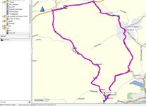
Route set to "Driving", Picture 1. Settings as picture 2.
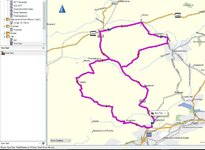
Route set to "Driving Tour", picture 3, settings as per picture 4.
Why on Earth has it taken me on such a route?
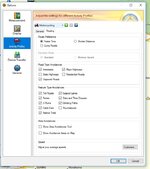
6 miles & 15 minutes longer? The only difference in the Route options is "State Highways" unticked. The road it's avoiding is a B road and the route it's taking is also a B road.
The second route even crosses itself and could take me back down the A682 to home on a road it's already planned for me to use on the outbound part of the trip but carries on into the back of beyond to get me home via Twiston & Roughlee.
Strange indeed. It's obviously the "State Highways" option which is cocking it up. How are we supposed to know what roads constitute each category!!!
Route set to "Driving", Picture 1. Settings as picture 2.
Route set to "Driving Tour", picture 3, settings as per picture 4.
Why on Earth has it taken me on such a route?
6 miles & 15 minutes longer? The only difference in the Route options is "State Highways" unticked. The road it's avoiding is a B road and the route it's taking is also a B road.
The second route even crosses itself and could take me back down the A682 to home on a road it's already planned for me to use on the outbound part of the trip but carries on into the back of beyond to get me home via Twiston & Roughlee.
Strange indeed. It's obviously the "State Highways" option which is cocking it up. How are we supposed to know what roads constitute each category!!!