Le Tour Summits

Chewie2112

Registered user
Joined
Apr 19, 2014
Messages
92
Reaction score
0
Location
Horncastle, England
Me and a mate are thinking of getting the ferry to Santander and then heading back up through the pyranees to the South of France before heading back to the UK.

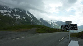
I'd love to see some of the iconic summits of the Tour De France, and the Tormalet and Mont Ventoux are on my list.

Anyone got any views on if they are worth it and if others are better.
 
I've not done all of them but the ones I have we're worth it only because it was on a push bike. Anything with an engine takes the climb out and that is when you realise how good the guys on Le Tour really are.

P.S. Don't use the toilet in the cafe at the top of the Tourmalet. It's the most disgusting I have ever seen.
 
The big ones are bleak desolate places, amazing views on a clear day, dismal on a crap day. Stuff up to 1500/1700m are likely to have trees, vegetation etc. if visiting the high peaks is to say you've ridden them, fine, otherwise I'd stay lower.
Aspect/Peyresoude/Mente etc in the Pyrenees. You can do a Pyrenean traverse that does all the good ones and end up near the Med. Ventoux is OK if it ain't windy and cloudy.
 
You could follow the route for the Raid Pyrenean. The start is at the right side of the country if you're going to Santander
 
Not done Pyrenees yet, planned for next couple of months
Try once over ventoux get onto D942 through Gorges du Nesque to Sault & Montbrun les Bains then Sisteron on D946
On to Barcelonnette D951 /900 ( One of my most memorable days riding) from there easy access to several TDF high passes including highest pass Bonette to south, Vars Izoard,
Galibier North. All fantastic riding
 
I 'did' the Pyrenees / 'all' the main passes by simply following the roads west to east on the map. It was fine.

It's a decent schlep from the Pyrenees to the base of Mont Ventoux in Provence but by no means impossible using good (non-motorway) N and D roads. As ever, a map is your best friend.

My patents lived for 22 or more years in Provence, so I went up and down lots of times. Not once did I get to the top for the 'perfect' day. More often than not it was quite nippy, even in August. Worth doing, just the same. Take a picnic lunch and eat it on the way up or down. In fact, take a picnic lunch on most days of your jaunt, so you can stop wherever the fancy takes you. Cheap, too.
 
In the Pyrenees you could easily take in the iconic cols of the tour during a days ride from west to east starting with Aubisque, Soulor, Tourmalet, Aspin, Peyresourde, Port de Bales and Mente or Ares followed by Portet d'Aspet and this route flows so you can ride them as part of your trip without a problem. In our opinion it is well worth doing not just for the great scenery but also some fantastic riding roads!

Cheers, Phil
Pyrenees Motorcycle Tours
ride the best roads
 
I 'did' the Pyrenees / 'all' the main passes by simply following the roads west to east on the map. It was fine. ...
Take a picnic lunch and eat it on the way up or down. In fact, take a picnic lunch on most days of your jaunt, so you can stop wherever the fancy takes you. Cheap, too.
Yes. Pretty much what i've done, twice. :bounce1 A michelin map with the pretty bits highlighted and the twisty bits obvious - a real joy and real easy. I'd do it again tomorrow. :thumb2
Taking your own grub and a drink is a very good idea. Sometimes you just wont want to stop, you'll be enjoying the bends so much. :D
Oliwoof,
i hate you! :P :D
 
In the Pyrenees you could easily take in the iconic cols of the tour during a days ride from west to east starting with Aubisque, Soulor, Tourmalet, Aspin, Peyresourde, Port de Bales and Mente or Ares followed by Portet d'Aspet and this route flows so you can ride them as part of your trip without a problem. In our opinion it is well worth doing not just for the great scenery but also some fantastic riding roads!

Cheers, Phil
Pyrenees Motorcycle Tours
ride the best roads

Do you know the road numbers?
 
Self reliant Adventure biking by numbers...

Do you know the road numbers?

Copy the name of each col individually.

Punch each, one by one, into Google maps

Look at where each are and the roads connecting them

Work out how you will join them up. Can't? OK, ask Google maps to join them up for you.

Here's a start for you:

https://maps.google.co.uk/maps?oe=U...s&sa=X&ei=8wGQU-rlPObT7AbSn4DwCA&ved=0CDEQ8gE

https://maps.google.co.uk/maps?oe=U...s&sa=X&ei=HgKQU9-aJeve7AbbxYGQDg&ved=0CEwQ8gE

https://maps.google.co.uk/maps?oe=U...y=s&sa=X&ei=2wKQU6uMH4aP7Aazs4Bg&ved=0CDEQ8gE

https://maps.google.co.uk/maps?clie...s&sa=X&ei=LQOQU-TMOKOO7AaTioCoAQ&ved=0CC8Q8gE

https://maps.google.co.uk/maps?hl=e...&ei=XQOQU_epA-SU7QalvYCYBA&sqi=2&ved=0CC8Q8gE

https://maps.google.co.uk/maps?oe=U...y=s&sa=X&ei=_gOQU7KkFMTo7AakvoFg&ved=0CDEQ8gE

PS It really helps if you have a decent map
 
Spanish side

Do you know the road numbers?

As earlier posted I intend to make a trip to Pyrenees later this month
Phil
Your route West East over Iconic TDF passes looks great , I wondered why not any mention of passes Spanish side ? TDF do not venture there or nothing of note .


Back
Top Bottom