M’off…… Hurtgen Forest….. August

Hopefully, this thread will give others the confidence to do something similar.

It doesn’t have to be ‘war stuff’ related, it just suited me to see something that is largely ignored or, just as likely, unknown. I’d have been just as happy just Googling ‘10 best things to see and do in the Eifel’ and taking my pick of some.

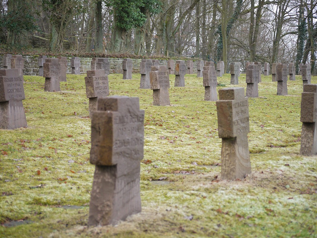
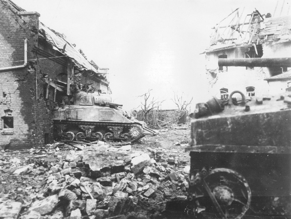
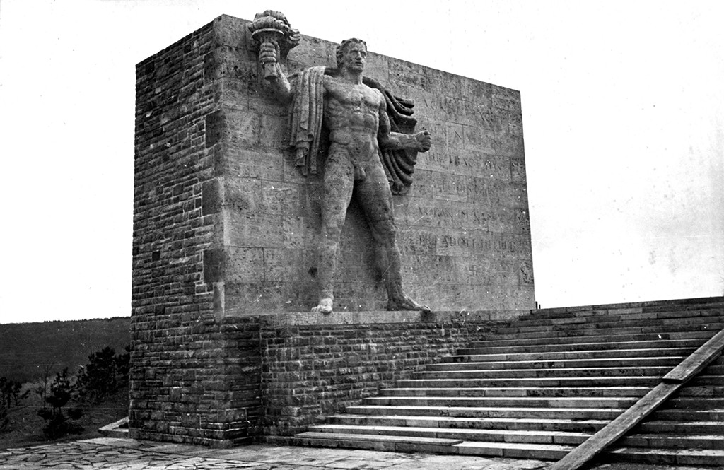
My aim was also to show (without any IT skills at all) how easy it is to do things. Everything was done on my iPhone, in a cafe and then sat in the pub, tapping into free WiFi. I just Googled up an AI suggestion, watched a video or two, skimmed through some organised tour stuff (unsurprisingly, they all do much the same ‘stuff’) and went from there. I guess the only slight advantage I might have had, is that I knew the very broad outline of the forest, its location and what went on in the mud, trees and snow of ‘44. That, and I know the tried and trusted way from Calais to get there and back.

I am pretty confident the German hotel in Simmerath will be ‘biker friendly’ and at least as ‘secure’ as anywhere else. I will though take a decent lock and use it, irrespective.
 
Very useful and interesting stuff here Richard. Thanks.

Our American friends are very good at ignoring well informed military counsel. They did it in 1918 in the Argonne and learned the same hard lessons Haig etc took 3 bloody years to learn. Likewise (and I learned this only recently) they declined our offer of reconnaissance of Omaha beach by (what became) the SBS. Not a great decision as the first 15 minutes of Saving Private Ryan might demonstrate.

Anyway, carry on and thanks again. :thumb

Thank you.

It’s interesting how fraught the relationship between the Allies became at times and, not least, between the three main arms, navy, army and airforce.

Towards the end, Roosevelt himself had tired of Churchill or, to be more exact, the overriding British concept of ‘Empire’ and believed he could tame ‘Uncle Joe’. But that is maybe not surprising, as Roosevelt was both sick and tired, schooled in the logic of independence, going back to the War of Independence from Britain. Churchill too, exhausted (himself a product of ‘Empire’) and fearful of Russian intent. That the three held together so long was a testament to their unfailing duty to see it through to the bitter end of Germany and Japan. What came after and how close we came to nuclear oblivion, is something else.

The politics of war, right back to the Middle Agrs, is fascinating, I think.
 
Just south oh Heimbach , on the L249, you will find the ‘Abtei Mariawald’ which is renowned for its pea soup. There is a small German WW2 cemetery just to the south of that. And the L249 dropping down from the 265 into Heimbach is an excellent hairpinned road.

Duren: I was told once that Duren was one of the most bombed towns in WW2. The town was famous for its paper-making and, in particular, it was where the paper for bank notes was made and printed. That was probably the reason for the bombing
 
Roughed out route between St Omer and Simmerath. 260 miles, diluted by taking the motorway between St Omer and Cambrai:

https://www.myrouteapp.com/en/social/route/11733147?mode=

======

I’ve now (24 July) tweaked it up a bit, not least by putting in two coffee stops (morning and afternoon) and a lunch stop. I’ve used all three before.
 
Last edited:
Car or bike?
Aah, you’re taking a lock.
Forget that. :D
 
Just south oh Heimbach , on the L249, you will find the ‘Abtei Mariawald’ which is renowned for its pea soup. There is a small German WW2 cemetery just to the south of that. And the L249 dropping down from the 265 into Heimbac

Found it:

IMG_1114.jpg


Last edited:
This website will probably come in handy:


IMG_1118.jpeg
 
Last edited:
A reasonably interesting amateur video on the battle of the Kall Trail, in the drive to attempt to take the strategically important town of Schmidt:

 
Last edited:
Out of sequence, but here’s the same amateur historian’s overview of the Hürtgen Forest battle:

 
img_1118-jpeg.429771


The Liberation Route’s GPX downloads are in sections. With a bit of jiggery-pokery, I have displayed each section in a different colour in MyRoute, to then create a route (in black) between them:

IMG_1119.jpeg

The Liberation Route ‘route’ includes significant parts that are walked, which I cannot cut into MyRoute easily, as it’s very on-road biased. The Torch Bearer monument * is an example. That doesn’t matter too much, as I can always stop at a point and walk, using a conventional map. It’s good enough for the purposes of my predominantly’on-road’ jaunt at least.

By then mixing in the points I have lifted from Google maps, I should have more than enough. Yes, I’ll probably miss a ‘must do’ or two, but hey-ho. Who knows, I might see something that’s not on any website or Google guide.


* The Torch Bearer is possibly interesting, as it predates WW2 but is a striking example of Nazi ‘approved art’ and mythology. It was erected at a Nazi ‘youth camp’, all very ‘Strength through Joy’ and indoctrination.


PS The Liberation Route concept is itself probably of interest to some, as well:

 
Last edited:
‘Strength through Joy’ was all but celebrated in the UK, as this Pathe News clip from 1938 shows, complete with its obligatory fat Nazi officials, laughing and applauding:


Opinions here at home changed within the year, obviously. Not least when British Tommies met fanatical fighting. Hamburg, lay in ruins just seven years later; no strength nor joy left.
 
Last edited:
The amateur historian’s video on ‘Hill 400’:


I’ll take it in during my trip. Oddly, it was missing as a point on the Liberation Route itinerary, so I have added it in.
 
Last edited:


Back
Top Bottom