Picos offroad/gravel

er-minio

Well-known member
UKGSer Subscriber
Joined
Mar 10, 2008
Messages
10,490
Reaction score
3,486
Location
London/Rome
I might be back through the Picos at the end of April (on the way to Portugal and then back).

I'd like to do some off-tarmac routes this time.
I've had a couple of pointers shared by Arsey after my trip report when I visited the area: https://www.ukgser.com/community/threads/gpx-picos-a-trip-report.402282/#post-5486826

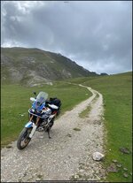
I'm not traveling on my own, people with me are less enthusiastic about leaving tarmac, and will have to keep the offroad bits ideally to what is shown in those picture: easy gravel routes.

Is there a source where I can find most of them, with some sort of description/photo or video reference? If they have been already ridden by people in here (like the example above) even better.
I just need pointers to where most of those are kept (in here or offsite), then I can sort out itineraries :)

Thanks in advance.
 

Attachments

  • 1773697881056.jpg
    1773697881056.jpg
    161.2 KB · Views: 29
Last edited:
Perfect, thanks a lot!
I think I found a few pictures (in other threads) of the Sotres/Espinama route and that's exactly the type of gravel route I'm looking for as it seems to be fairly easy/straightforward, so my mates would be ok with it.

Curious about other tracks around :)
 
Perfect, thanks a lot!
I think I found a few pictures (in other threads) of the Sotres/Espinama route and that's exactly the type of gravel route I'm looking for as it seems to be fairly easy/straightforward, so my mates would be ok with it.

Curious about other tracks around :)
It’s stunning up there

 
The Sotres/Espinama trail is pretty much the only one legal in Cantabria which has a blanket ban on off road for anyone other than residents with special permissions.

Maybe check out the TET Spain for ideas?
 
Most of the Sotres to Espinama route is on Streetview
 
As Simon said, there’s a TET route that has some stuff in Northen Spain, but check it carefully- some of it is quite difficult on a big bike. But I think from memory there’s hardly any actual legal dirt trails in the Picos.

I’ll also check out ACT, as I have a subscription- their routes tend to be a bit easier
 
Thanks.
Looks like the plan is to do only that specific bit in the Picos then.

I'll check TET/ATC routes as we travel towards Portugal and back too. I did small part of the TET in the Pyrenees years ago, and we found a small stretch that was fairly easy to approach on loaded heavier bikes.
 
Take a look at the TET between Potes and Cangas de Onis, very scenic route and I think possible on an adventure bike if it's dry but, my idea of 'easy off road' maybe different to yours!

There are plenty of YouTube videos which show the route from a riders eye point so you can judge for yourself.
 
Take a look at the TET between Potes and Cangas de Onis, very scenic route and I think possible on an adventure bike if it's dry but

Yep, re-downloaded the TET tracks (the ones I have are from years ago and didn't include this).

The bit you mention is the same one mentioned above and visible in the video from Arsey.
Looks like it is a simple gravel route: exactly what I'm looking after as my mates will be ok riding on this, no drama involved.

Screenshot 2026-03-17 at 09.37.52.jpg

This bit goes in the trip planning the, missed it last time.
 
Last edited:
Thanks.
Looks like the plan is to do only that specific bit in the Picos then.

I'll check TET/ATC routes as we travel towards Portugal and back too. I did small part of the TET in the Pyrenees years ago, and we found a small stretch that was fairly easy to approach on loaded heavier bikes.
The ACT trail in Portugal is easier. A lots of the TET there is in all honesty a bit tedious, taking a massive detour to do 2 miles of shitty farm track in a village, for no reason other than its unsurfaced.
 
taking a massive detour to do 2 miles of shitty farm track in a village, for no reason other than its unsurfaced

A bit like some sections of the TET south of England then. :D
I've done parts of the TET in Switzerland too where it was mostly short bits of slightly worse tarmac (but I also assume the Swiss are very strict over going off road) :)

Jokes apart, I understand. I'll sign up for ACT.
 

Check round this area, maybe include to/from Picos, passed through it a few years ago - easy un-surfaced with other un-surfaced roads in the area
 

Link to ACT Portugal - it's a straight North to South route

Screenshot 2026-03-17 at 13.59.47.jpg
 
Thanks a lot! Downloaded!
To be fair, I think I should have had that somewhere now that I think about it. I was planning to do it two or three years ago, but no one of my usual travel mates wanted to do it.

My sister lives in Spain, Marbella. So the plan was to take my time via ACT Portugal to get there, stay there for an extra week resting and then heading back to Bilbao.
Hopefully it will be on of the next trips.
 
I have just done two days of off roading on the tracks around where I live, large rocks are falling even though it is dry, one of them must have been in excess of 2000kg!, we had to ride around it, many tracks closed because of fallen trees, it is a bit of a pain in the arse at the moment....I am taking a chainsaw next week, fed up with turning back! The tops of the mountains are obviously clear, so we decided to stick to those tracks. I am where the storms went through though, I think it is better up north and the tracks are often different from one month to the next, water erosion, pig holes, falling rocks etc.

Nothing is guaranteed.
 
Mini trip report (Wapping, split the thread if you think it's worth) and thanks again for the tips.

This year it ended up being a larger group (I normally do not travel with more than another bike or two). 10 in total: 3 of us from the UK, rest of the people coming from Italy (mostly Rome) via ferry to Barcelona and one person reaching from Morocco where she was traveling by bike as well.

We arrived in Santander (24th) and met the others in Pamplona.
The initial itinerary was meant to go across Picos, all the way to Portugal (Porto, Douro, Estrela) but I had to cut the trip short by a few days, so looped back with the other two after a quick jaunt in the Douro valley and jumped on the ferry back on the 3rd.

This is the full route:
Screenshot 2026-05-07 at 00.56.53.jpg

We did get a fair bit of rain, to answer the common question "how's the weather in the Picos in XYZ" :D
From Pamplona, we traveled to Embalse del Ebro, just before the picos. Then did a loop around Picos to Fitu and Canga de Onis.
Day after the group was supposed to split, half doing the asphalt route (clockwise) the other half going through the Sotres/Espinama gravel bit.

Given the fairly shit weather everyone decided to go semi-directly towards Leon (next stop). At the end I decided to chance it, and glad that I did it.
I think the gloomy weather and low clouds add to the atmosphere.
A friend rode up with me to the start of the route in Sotres and then went back down the tarmac route to Potes where we met. Then a couple hundred kilometers in torrential rain towards Leon to re-join the rest of the group. :)

In Portugal we rode across (mainly) the N103 from around Bragancia towards Porto, that is a pretty much a racetrack for the first half, very enjoyable to ride at a decent pace. Random greasy restaurant along the route with pretty decent portions for 10 quid per person including coffee :D
I split from the group to meet (and stay with) some friends in Porto for the night, then rejoined them the morning after on the 222 going west. Some of the views on the 222 are beautiful, but traffic and closures do not help much and it's not very enjoyable. It was the 1st of May, so maybe that made it worse given the higher vacation traffic.

We stopped slightly east of the Park Natural de Arribes del Douro, mostly because of the shortage of accommodation (again, 1st of May).

From there we split, and the three of us UK-based rode back towards the Picos (again, semi miserable weather, so we took a direct route) where we stayed in Cahecho (Posada Torcaz). Fairly basic accommodation, but super friendly, hidden slightly high up and decent restaurant (very good tagliata) in the village.

The route above is the track from my Zumo, but I do have the individual days (tracks and routes) that I plotted before leaving, in case.

Zumo was surprisingly compliant for the first couple of days, then started acting out magnificently. I decided to get rid of it (and probably give Garmin one last chance switching to a Montana with inReach) but that will be the topic of another thread I guess :D


A few snapshots:

36 hours at sea
atsea.jpg


“Ruins” near Fitu
ruin.jpg


A fairly wet Sotres/Espinama
gravel-selfie.jpg


gravel00.jpg


gravel01.jpg


"We need two parking bays..."
garage.jpg


Tiles say it all
tenner.jpg


Cahecho
torqaz.jpg


top.jpg
 
Last edited:


Back
Top Bottom