Round trip to Andenes in 25 days

Day 11

The route for today is -

Route_Day11.JPG


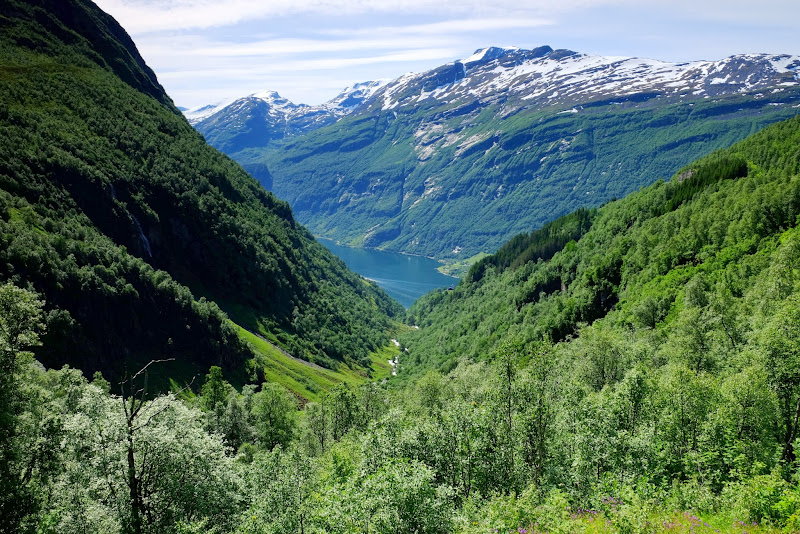
It is quite overcast as I get ready to leave. I pay cash to the host's Dad (I think) and ride off about 0915, initially North towards Andenes, then taking the road along the West coast of Andoya past the fishing village of Bleik, heading South. I pass the Andoya Space Center which I noticed before but didn't get round to seeing whether a visit was feasible. The low cloud mist does make for a slightly mysterious atmosphere as I travel down the island.

DSCF3112.JPG


DSCF3113.JPG


DSCF3115.JPG


DSCF3118.JPG


Having ridden down the West coast I traverse Andoya and from Risoyhamn - where I see a Hurtigruten liner coming in to dock - I start to retrace my upwards journey to where I cross over the bridge to Sortland, on Langoya island. This time I cross for real, on the way up I crossed over and back just for the hell of it.

DSCF3119.JPG


I'm on road #82 a.k.a. Kong Olavs veg (again), and it is sandwiched between cultivated fields and the fjord. You can see opposite the coastline of Hinnoya island, also the weather has improved quite a bit. Nice easy riding.

DSCF3120.JPG


DSCF3122.JPG


DSCF3125.JPG


DSCF3127.JPG


Another bridge, and I have crossed from Langoya island to Hadseloya, and then on to the port of Melbu.

DSCF3129.JPG


DSCF3132.JPG


Melbu. Where the only sensible way to get to the Lofoten islands was to get a ferry to Fiskebol. Which was a bit of a surprise since I now realised that I had assumed that the GPS would have taken me the alternative route which used the E10 and avoided ferries. Clearly this upset me as I am not wont to travel in such an unplanned and impromptu manner. And the ferry to Fiskebol had left 25 minutes ago. What to do? :(

Well obviously the answer was to relax, and go and have something to eat at the Melbu hotel (I had Bacalau again, though not as good as the version I had in Fauske). In fact I didn't have too long to wait, and on board the ferry had a brief chat to 3 Swedish bikers on KTM who were returning from a quick and dirty trip to Nordkapp. After a smooth 40 minute crossing we approached Fiskebol.

DSCF3144.JPG


After disembarking, the road became very scenic but I felt pressured not to stop because there was a lot of traffic from the ferry and I didn't want to be held back. In hindsight, I should have stopped and taken a photo as a reminder - I wouldn't have lost so much time. Amyway, the GPS sends me down a scenic route so I avoid the E10 to Leknes and instead hug the coast - slower, but nicer looking.

DSCF3147.JPG


DSCF3150.JPG


DSCF3152.JPG


I can't find my stopover for 2 nights (Hagstua - £214 for a cabin for 2 nights) very easily so have to phone - but get there at last thanks to instruction from Kenit, the owner. I unpack my gear into the cabin that will be my home for 2 nights.

DSCF3154.JPG


I follow Kenit's recommendation and eat at a fish restaurant in Leknes town, then buy a couple of beers in a supermarket and bring them back to the cabin. After a Skype call home to Jersey (on the balcony of the main house / restaurant - the WiFi doesn't reach as far as my cabin), and a brief walk up the hill behind the cabin to take a couple of pictures, it is time for bed. The first image is a view from my cabin balcony, the last two are from just up the hill.

DSCF3155.JPG


DSCF3162.JPG


DSCF3160.JPG


Miles ridden today ~ 160
 
Day 12

Route for today -

Route_Day12.JPG


I have breakfast in the main house / cafe as previously agreed with Kenit, the owner. The cafe is normally closed at weekends as there is not enough trade, but this Sunday he has opened specially for me - I am the only customer. We talk about the ferry between Moskenes and Bodo... I had been worried as I couldn't seem to book online for the 1030 sailing on the 13 July, but apparently they only allow prebooking up to a certain number of vehicles, the rest are left available for those that turn up on the day. Kenit phoned a mate of his who used the ferry frequently and he thought I would be OK. Good news, as I didn't fancy getting up at stupid o'clock in the morning to get the earlier 0600 departure, which still had bookable spaces.

With that sort of settled, I set out to explore the Lofoten islands. The weather is lovely today. First I head South down the E10, stopping at Skagsanden beach for a coffee, and taking snaps of the coastline and the fish drying racks on the roadside (I did sample a dried fish snack in Andenes, can't say that I'm a huge fan really :barf ).

DSCF3167.JPG


DSCF3169.JPG


DSCF3173-1.JPG


DSCF3179.JPG


DSCF3181.JPG


I stop briefly in Reine, a very picturesque fishing village.

DSCF3182.JPG


DSCF3185.JPG


DSCF3187.JPG


DSCF3189.JPG


A few miles further on I arrive at the small fishing village of A. This is pretty much as far South as you can go on the island in a vehicle. The village has a very popular artisan bakery, there was a long queue to get a pastry and coffee but it was worth the wait and I sit in the sun afterwards to soak up the warmth. There are some interesting reflections in the water of the rorbu (fisherman's huts) and there is a good view North up the coast.

DSCF3190.JPG


DSCF3191.JPG


DSCF3202.JPG


DSCF3217.JPG


Next I retraced my route on the E10, taking another snap of Reine on my way past before turning East onto the road to the fishing village of Nusfjord, just near a sandy tidal basin.

DSCF3218.JPG


DSCF3268.JPG


At Nusfjord I parked the bike in a small car park above the village - with quite a steep entrance / exit but a good view over the waterfront - before paying the NOK 50 entrance fee to look around. There is a small semi-open area cafe attached to one of the restaurants which had WiFi so after my promenade I was able to use the web to book my accommodation on the mainland for Monday night over a coffee before the cafe shut about 1730. Dried cod heads feature heavily in the village, and there is a small museum of old marine radios together with some innovative modern architectural seating arrangements.

DSCF3262.JPG


DSCF3230.JPG


DSCF3236.JPG


DSCF3243.JPG


DSCF3258.JPG


DSCF3235.JPG


Time to go, and I had heard that the small village of Eggum is where many Norwegians go to watch the midnight sun so I ride back on the E10 through Leknes towards the West coast. There is not much at Eggum, a gravel track for which it seemed you needed to pay a small fee to use takes you a short distance to the remains of an old German radar installation. There is a small cafe nearby where I had a meagre supper of 3 chicken wings and chips with a coffee. Loads of camper vans were setting up for the evening, but as there were no clouds in the sky (and so in my view little chance of a photogenic midnight sun scenario) and it was starting to cool down, I head back to Leknes and bed.

DSCF3271.JPG


DSCF3278.JPG


DSCF3284.JPG


Miles ridden today = 120
 
Day 13

Route for today -

Route_Day13.JPG


Had a quick banana for breakfast before leaving Hagtua and riding via Leknes to Moskenes ferry port. Turned out there was very little traffic and with the journey taking just less than 60 minutes I arrived just after 0830. I was the first bike in the queue, but was joined later by several others and eventually all the bikes are asked to go to the front where we are given tickets.

DSCF3287.JPG


DSCF3290.JPG


DSCF3289.JPG


After the ferry arrives it seems to take ages for them to unload the vehicles - and unusually I think, in this case the bikes were the last off - but eventually we are told to board and I am the first bike on. In my eagerness I take a 'short cut' onto the ramp and manage to get my front wheel tangled up in a rope strung between to traffic cones - luckily my red face is not visible under my helmet :augie .

Looking back at the Lofoten islands I wonder if I should have stayed longer - I would certainly return again.

DSCF3292.JPG


DSCF3296.JPG


DSCF3298.JPG


The crossing took around 3 hours and was very smooth, we soon started the approach to Bodo, arriving around 1415. This was over an hour later than I expected, it turned out that I had misread the timetable, so the rest of the day's ride would prove interesting as I may not be able to reach various ferries in time to catch them. It didn't really matter since I hadn't pre-booked any ferries, but I might have to wait a while if I missed the one I had planned to get. I'd have to see how it went.

DSCF3302.JPG


DSCF3314.JPG


DSCF3320.JPG


DSCF3317.JPG


The exit from Bodo was a bit confusing, but I get on the road (#17) to Foroy and with only stopping for petrol and one photo (below) I arrive at the Foroy ferry terminal at 1644 just in time to get on the boat! There were a few tunnels en-route which were quite good as they were much cooler than the normal ambient temperature

DSCF3322-1.JPG


It just a short voyage before arriving at Asgkardet though we get a good view of a glacier on the side of the fjord, it is then just a brief ride to Jektvik for the next ferry - here I have a 40 minutes wait, and there are lots of people in the queue...

DSCF3324.JPG


DSCF3327.JPG


DSCF3329.JPG


The next voyage is a bit longer: once on board I have burger and chips as an early 'supper', and 30 minutes after leaving Jektvik heading South we pass a symbol marking the Arctic Circle.

DSCF3330.JPG


On leaving the ferry at Kilbogham I have to spend a few minutes sorting out my satnav, and as a result I found myself in a convoy of slow traffic heading towards the next ferry at Nesna. I got stuck behind a series of campervans and because this stretch of road has quite a few sections that are essentially single lane only with few official passing places I made slow progress. Once past these obstructions (some of the more aware drivers did pull in to allow me to pass, but not all) there were however some beautiful views of fjord and mountain along the route. I didn't stop for photos as I was worried about ferry timings, though it turned out that I could have done so. I found the descent into Nesna quite challenging with a couple of sharp hairpin bends that almost took me unawares (going too fast - my fault). At Nesna there is already a queue for the ferry and I have plenty of time to refuel before the next sailing.

DSCF3335.JPG


DSCF3337.JPG


We arrive at Levang - that was the last ferry for today! The last leg of the ride today was about 20 miles from Levang to Sandnessjoen, ending with with the stunning Helgeland bridge - really beautiful - just before arrival in Sandnessjoen. I stop briefly at the side of the fjord to take a distant picture of the bridge as the sun goes down.

DSCF3365.JPG


DSCF3367.JPG


I check into the Scandic Sye Sostre (£90 room only for 1 night). The hotel is modern but has no secure parking, so I unloaded the bike near the main entrance but then moved it round to the back of the hotel where there were a couple of other bikes already parked. It's quite late by the time I have finished checking in etc., so before bed I just have a couple of beers in the hotel bar whilst doing a bit of route planning and booking accommodation for tomorrow night.


Miles ridden today - 320 - 80 (ferries) = 240
 
Thank you for taking the time. This takes me back to when I rode a similar route a few years ago as I wandered back from Nordkapp. It's a fabulous part of the world. Your photographs are excellent. :thumb2
 
Amazing!! What was your total mileage for trip and is you a crapaud? 👅

Sent from this Android pile of shite using Bolloxchat
 
Thank you for taking the time. This takes me back to when I rode a similar route a few years ago as I wandered back from Nordkapp. It's a fabulous part of the world. Your photographs are excellent. :thumb2

Glad you like the photos John - and thanks for your input on the general shape of the trip - you very kindly shared your route with me a couple of years ago when I first started thinking about going to Norway. Although I didn't make it to Nordkapp I thought the post of your trip was really good and inspired me to do similar. :beerjug:
 
Day 14

Route for today -

Route_Day14.JPG


Pickled herring may not be everyone's idea of something to have for breakfast, but I like pickled herring and when in Rome etc.... so I tried two different sorts of the fish in addition to more conventional scrambled egg and bacon from the large buffet. Plus a Danish pastry and coffee, and an apple (for later). I liked the Scandic hotel and had booked another one in Namsos, my intended destination for today.

I arrived at the Tjotta ferry about 1000 after a 40 minute ride. It was not very sunny today, but quite grey and gloomy. Being British I dutifully queued up behind cars already there, though I found out later during a chat with a Norwegian biker and his girlfriend that it is expected that bikes jump the queue to the front, the ferry loaders apparently prefer this. For the rest of the trip I generally followed this advice, although once or twice it was made clear that bikes should wait in line with the rest of the vehicles. :nenau

DSCF3374-1.JPG


DSCF3372.JPG


I stayed on deck for the duration of the relatively short trip just to see the captain navigate through some what seemed to me very narrow channels. I suppose when you do the same trip many times a day it becomes second nature. I stupidly left the camera on the bike so didn't get any pictures during the voyage. There was a group of Belgian bikers on the ferry, but they zoomed off quickly once we docked in Forvik - I followed at a more moderate pace, stopping in a couple of places to take pictures. However when I got to the next ferry at Andallsvag I saw a gap at the front of the queue and went for it - the Belgian bikers commented on this act of anarchy. There was not much going on at the ferry terminal here, as you can see from the following images.

DSCF3375.JPG


DSCF3379.JPG


DSCF3384.JPG


DSCF3385.JPG


It is seemed only a matter of minutes for the ferry to get from Andallsvag to Horn - it was a very small boat with limited facilities. When we disembarked the Belgian group raced off - with some silly overtaking in my view :rob , but that may be just my age and IAM colours showing. Anyway, the Belgians headed off to Bronnoysund whereas I continued on the RV17 for a quiet and relaxing ride to Vennesund where I slavishly followed the newly learnt Norwegian biker custom and passed the long queue to the front (I'm the second vehicle on the boat).

DSCF3389.JPG


DSCF3396-1.JPG


DSCF3395.JPG


A slightly bigger boat this time with more facilities, so I have a coffee. For some reason my predicted ride times are way out, this time I am arriving earlier than expected. Not sure what is going on, but either the GPS estimates or my calculations must be at fault. No matter.

DSCF3390.JPG


The ferry docked in Holm and the ride from here along the RV17 towards Namsos was lovely, with bends, fjords, mountains, just all gorgeous. I stopped once to refuel the bike and have something to eat during the afternoon. I tried the Norwegian version of a hotdog / weiner sausage called a pølser...

DSCF3398.JPG


OK, I admit I'm not a hotdog fanatic generally, but this pølser was a vile rubbery item with gristle that almost defeated me (I was hungry, so I ate it). Perhaps it was just a bad example of the genre, when I return to Norway I will try it again, perhaps just not in a service station.

I arrive at my hotel in Namsos at 1715. I had booked a room at the Scandic Rock City hotel (£90 per night for room only) - it is adjacent to the Rock City Resource and Exhibition Centre which I didn't visit. Anyway, although I'd booked a room for the night I was wondering if I should press on to Trondheim so that I had more time there - the receptionist at the Scandic Rock City was really helpful and confirmed that they had availability in the Scandic Bakklandet in Trondheim should I want to go there, and that it had secure parking available.

After a bit of indecision I opted to stay in Namsos for the night, not least because according to the GPS it was between 3 and 4 hours riding time to Trondheim from here using the route I wanted to take, a bit too long to be comfortable at this time of day (for me anyway). So instead, at the receptionist's suggestion I park my bike right next to the entrance, under the awning, and after unpacking the bike took a brief stroll along the Namsos waterfront...

DSCF3403.JPG


DSCF3404.JPG


... before heading back to the hotel for something to eat and drink, then bed. A much more relaxing evening that would otherwise have been the case (see report to the following day)!

Miles ridden today ~ 177 - 17 (ferries) = 160
 
Day 14

Route for today -

Route_Day15.JPG


Scandic hotels do good breakfasts with loads of choice, and I took full advantage of what was available. It would have been nice if it had been sunny but instead a light drizzle started as I left Namsos around 1000 (I'd had a bit of a lie-in). Rather than carry on to the E6 and then to Trondheim, I had decided to turn off onto the smaller and hopefully more scenic RV720 before getting the ferry from Rorvik to Trondheim.

It started well enough.

I left the RV17 and joined the RV720 just after Sprova, but in Verran the GPS instructed me to take a right turn off the 720. It was a single lane tarmac road which climbed quite steeply into the hills and I assumed that it was going to be one of the scenic short-cuts that the Garmin seemed quite keen on providing me from time to time. However, I was unnerved when the tarmac disappeared into a graded mud / gravel surface. It was smooth, but also damp and I was very uncomfortable! I thought it may just be a temporary section but it wasn't; it lasted for nearly 9 miles, and included a scattering of sheep on the road and cattle grids thrown in for good measure.

Nothing to worry a seasoned off-roader, but as you may have garnered from earlier posts, I have only ridden on tarmac - and my bike had Conti Trail Attack tyres, not knobblies. I took a snap of the road, but it doesn't look anything like as dodgy as it felt at the time!

DSCF3413.JPG


In hindsight, I should have turned round but I can quite obstinate and I guess I'm glad I did continue, but I was really glad to regain the tarmac at Follafoss, where the RV720 welcomed me back with a pleasant ride along the side of a fjord, with loads of flowers at the roadside.

DSCF3414-1.JPG


DSCF3418.JPG


I should probably mention that although tarmac, the RV720 is not a big road - it undulates along the fjord through small farming communities, so it was quite a surprise to meet a large Scania truck coming in the other direction.

You will be glad to know that the width of the road = width of Scania + width of BMW R1200GS + a tiny bit to spare (but not much).

After this encounter I stopped at a fjordside picnic spot to recover before getting back on the road to Rorvik (more flowers).

DSCF3420.JPG


DSCF3425.JPG


DSCF3426.JPG


I arrived in Rorvik and once again overcame my British queuing instinct to wait for the ferry across to Trondheim.

DSCF3437.JPG


DSCF3438.JPG


It was quite a squash on the vehicle deck once the lorries had been loaded...

DSCF3441.JPG


I found the Scandic Bakklandet hotel (£82 / night for room and breakfast) without too much difficulty, it is located on the side of the Nidelva river at one end of a bridge. The hotel doesn't have its own secure parking, but it is adjacent to a multistory car park. I managed to sneak past the barrier to park the bike in a corner (not sure if this was entirely legal :augie ), and having changed out of bike gear I set off to explore a bit of Trondheim.

DSCF3450.JPG


DSCF3454.JPG


I like going up towers, so I couldn't resist buying a ticket to visit the cathedral which included a tour up the spire, with a good view over the city of Trondheim.

DSCF3474.JPG
- this was an 'in camera' panoramic shot

DSCF3483.JPG


DSCF3488.JPG


I then returned to the hotel via the Bakklandet district, which is an area of old Trondheim that has been renovated / gentrified and has a bit of a 'hipster' feel to it, with lots of coffee shops and restaurants. For a change - and avoiding the advertised Bacon Pølse, I had an early supper at a restaurant specialising in Spanish tapas. Then I took a couple of 'long exposure images before returning to the hotel to plan the next day's route.

DSCF3502.JPG


DSCF3495.JPG


DSCF3527.JPG


Miles ridden today = 110 - 5 (ferry) = 105
 
Day 16

Route for today -

Route_Day16.JPG


Another 'Scandic breakfast' including multiple pickled herring options :) sets me up to the day - after packing the bike and checking out of the hotel I am on my way out of Trondheim by 0845, initially on the E6 but soon turning off West onto the E39. The main event scheduled for today is to ride the fabled and iconic 'Atlantic Ocean Road', a 5.2 mile section of the RV64 linking several islands in an archipelago to mainland Norway.

The weather is not looking good, with a light rain as I start off which turns increasingly persistent and heavy as I go on. Very unpleasant. I nevertheless find the time to stop to take a photo of a Norwegian house in the rain.

DSCF3532.JPG


I find myself behind a couple of bikers on Harley Davidsons weaving their way along, and follow them onto the ferry at Halsanaustan. I get to Kristiansund just before 1300 and park the bike so I can get a hot meal (toasties - good) and a coffee to try and warm up a bit (I feel cold and wet, but it is all in the mind and my clothes under the bike gear are dry). The cafe I chose was friendly but I am very surprised to see that just across the street there is a branch of Specsavers, whose headquarters is in Guernsey, just a stones throw from Jersey where I live. It is a small world.

After this welcome interlude from the rain, I get back on the bike and find the long tunnel which takes me to the first island in the archipelago linked by the RV64. In this weather I am happy to be out of the rain, even if it means being in a tunnel under the sea! The Atlantic Ocean Road is a toll road (or was in July 2015), so I paid for the privilege of travelling along it. It seems to me there is only one really stand-out bridge on the road, and considering the bridges I've seen previously on this trip I'm not overly impressed. But it may just be the weather, which doesn't help. Anyway, I thought I'd better stop at the visitor centre and take a moody / atmospheric photo in the wind and the rain.

DSCF3537.JPG


I moved on swiftly, stopping only to take a snap of another bridge later on...

DSCF3545.JPG


Just after reaching mainland Norway at Vevang, I turned off the RV64 and followed the smaller road RV663 via Farstad down to Molde, and then via another long undersea tunnel on to Solsnes where I got the second ferry of the day. I take it easy for the rest of the way to Andalsnes and arrive at the Grand Hotel Bellevue (£98 for room and breakfast) around 1800.

DSCF3546.JPG


There was open parking available opposite the hotel and there are a few other bikes (BMWs :D ) already there. After unpacking I had a quick wander round in the drizzle / low cloud to have a quick look at the town, which has a port and railway station, and a very strange carving...

DSCF3551.JPG


DSCF3554.JPG


DSCF3569.JPG


I ate at the hotel restaurant, although as the main dining area was allegedly fully booked I found myself in an annex along with a few other people. It actually suited me better, as there was more space and it was also less formal. I had an Elk burger and a beer, and I can recommend the Elk burger!

Hunger sated, I tried to work out my route and accommodation for tomorrow. I wanted to get to Ardalstangen, within easy reach of Flam and its railway, but was unsure about part of the route that the GPS was suggesting - it looked almost like an unmade track :eek: . So, I checked with the hotel reception, and they thought that the section was a real (i.e tarmac) road called the Tindevegen, which is a scenic toll road - I hoped they were right!

Miles ridden today ~ 210 - 5 (ferries) = 205
 
Day 17

Route for today -

Route_Day17.JPG


Andalsnes to Ardalstangen, that was the plan. I'd worked out the route to include the Trollstigen road and Geiranger fjord. And when I looked through the window in the morning it looked like I would have some good weather for the ride.

DSCF3571.JPG


I was a bit surprised to see a cruise ship anchored in the fjord, but I guess Andalsnes is a popular destination with its boat / railway hub.

After a reasonable breakfast I left the hotel around 0815, stopping briefly to get petrol before setting off to the Trollstigen (Trolls path) which is part of RV63. I started on the E136, and then turned off onto RV63 is quite small and would be quite easy to miss. The countryside was initially quite rural...

DSCF3573.JPG


... but quite soon the road started to climb up and I was into steep hairpins, most of which I managed relatively well. There were quite a few coaches and I succumbed to the urge to use the bike's superior power overtake (sensibly, of course).

DSCF3575.JPG


DSCF3578.JPG


The view from the top was breathtaking, although the following images don't really do it justice partly because of the difference in light levels across the valley. At the top I got off and had a look from the various viewing platforms. As you can see, it was quite busy with tourists.

DSCF3588.JPG


DSCF3593.JPG


DSCF3594.JPG


DSCF3597.JPG


Anyway, enough of the Trollstigen. I left the very busy tourist centre and headed on along the quiet road passing some lovely lakes and mountain views until at last I arrived at the Linge - Eidsdal ferry.

DSCF3607.JPG


DSCF3608.JPG


DSCF3616.JPG


I had just missed a ferry but only had to wait for 15 minutes until the next one arrived (there are 2 ferries on this short route), and we were soon heading across to Eidsdal.

DSCF3619.JPG


DSCF3625.JPG


It is just 11 miles or so on the RV63 from Eidsdal to Geiranger fjord, but around the half-way mark I found the lovely Eidsvatnet lake, where I stopped to take a few photos and have some water and a banana (sequestered from the breakfast buffet).

DSCF3645.JPG


DSCF3639.JPG


DSCF3632.JPG


After this short break I resumed my way over to Geiranger, stopping once or twice at viewing points on the way down to the small town at the head of the fjord, where I had a sandwich and coffee at a cafe overlooking the marina. The viewing points were very busy with coaches etc. and on at least one occasion I found it tricky to get a safe parking spot.

DSCF3650.JPG


DSCF3653.JPG


DSCF3656.JPG


DSCF3660.JPG


Lunch over, i rejoined the RV63 and climbed South East out of Geiranger, where there was a good viewpoint looking back along the fjord. Actually, it was then that I realised that I had missed visiting a viewpoint before the Trollstigen that I had read (in the Rough Guide for Norway) had a good over Andalsnes - it would have to wait for a future visit.

DSCF3672.JPG


The road threaded through a long valley before more hairpins led up to a high plateau with snow and ice very much in evidence.

DSCF3674.JPG


DSCF3676.JPG


DSCF3679.JPG


DSCF3680.JPG


Eventually the road reached what was then (July 2015) a semi-frozen lake, which I think is called Dujpvatnet. The images that follow were taken first at the Western end and then from a point along its North coast towards the East end, where I set up my tripod and attempted another panoramic shot.

DSCF3684.JPG


DSCF3688.JPG


Ice_lake_DSCF3706-16_hires_pan_11.jpg


A few miles further on the road joined the RV15, carrying on Eastward along the edge of Beiddalsvatnet lake, with another great view.

DSCF3721.JPG


DSCF3720.JPG


At this point the road was not busy and had a higher than normal 90kph speed limit (I think) so I made good progress. Sadly most of the remaining 50 miles to Lom were slow and I was glad to stop and refuel. At Lom I took the RV55 heading South West in the direction of Sogndal.

Once more the road started to climb out of the green valley before winding through a snowy landscape - you may be able to spot tiny Nordic (cross-country) skiers in the distance in the second of the following images (correction: as far as I know they were full size human skiers, the figures are only tiny due to distance and perspective :D ). The snow was also still quite thick close to the road in some places...

DSCF3726.JPG


DSCF3729.JPG


DSCF3734.JPG


As the road began to descend again I spotted a small left-hand turn off to the Tindevegen. For more information (and some better images along this road) you should visit the Tindevegen website http://www.tindevegen.no/ - note that this website is only in Norwegian. There was no barrier at this end of the Tindevegen, and as it is only single lane in most places you need to take care going round blind corners (like you always do) - and there are a lot of bends! An additional hazard was sheep and cattle wandering on to the road as there are few fences. I can confirm that the Tindevegen is tarmac all the way, and although my new GPS' 2017 maps (Garmin zumo 590LM) still show it as an 'alley' it appears to treat it as a normal road for routing purposes.

DSCF3735.JPG


DSCF3737.JPG


DSCF3738.JPG


DSCF3740.JPG


This is the paying end of the Tindevegen, which when I passed through was unmanned and credit cards only. After the toll booth, the road descended into Ardal where I joined the RV53 into Ardalstangen.

DSCF3742.JPG


I checked into the Klingenberg Hotel (£79 for bed and breakfast),. The hotel is situated on the waterfont and my room had a good view over the small port into the fjord. I was able to park my bike in a small yard behind the hotel, which felt a bit more secure than leaving it on the street.

DSCF3743.JPG


After scampi and pasta with a couple of beers in the restaurant attached to the hotel (I was surprised to find out that the waitress was Slovakian), I had a walk along the waterfront and took a few photos of the fjord in the evening light before going back to the hotel to plan the route to Geilo.

During my stroll I also witnessed the local tradition of a group of young men pushing a blindfolded friend (?!?) in fancy dress off a pier and into the fjord. It may have been a stag do. Happily, the guy didn't drown and got out safely, though he seemed (understandably I think) quite annoyed.

DSCF3759.JPG


For me, today's ride had been brilliant, definitely helped by the good weather. According to the hotel receptionist rain was forecast for tomorrow: however, I was taking the trip one day at a time and was happy to would wait until the next morning to see if the forecast was correct.

Miles ridden today ~ 180 - 2 (ferry) = 180
 
Day 18

Route for today -

Route_Day18.JPG


I woke up to the sound of steady rain, just as the receptionist predicted.

Never mind, I had planned a relatively short ride today, just 125 miles with - guess what, no ferries. The first section would be from Ardalstangen to Flam (pronounced Flom) where I had pre-booked a place on the 1220 train to Myrdal with a return journey leaving Myrdal at 1327. I didn't plan to get off the train at Myrdal, it will just be a 'there and back' journey - all about the train.

By default my GPS wanted to take me via the E16 which included riding through a 15.5 mile tunnel (the Laerdal tunnel). And given that it was raining maybe that would have been a sensible choice, but I had gone off long tunnels as my trip had progressed, finding some of them - the ones that are poorly lit, with uneven sides, and with bends in the middle - particular unnerving, and I sometimes felt quite disorientated. So I plotted an alternative route to avoid the the Laerdal tunnel by going over the top of the mountain on road FV243 which was longer, but I hoped more scenic and enjoyable.

After filling up with fuel at Ardalstangen I set out heading South West on the RV5. At the second roundabout in Laerdal, instead of taking a left and following the RV5 to meet the E16 (and thus onward to the Laersdal tunnel) my alternative route meant I turned right along the 'Habnavegen' and so to the FV243, which in just under 2 miles turned away from the fjordside and started climbing up the mountain alongside a river. I started to see where all the rain was going.

DSCF3762.JPG


Initially this was a very minor road, as in narrow (just over one vehicle wide), poorly maintained (with rocks showing through the tarmac in some places), and with the odd cattle grid and flocks of sheep on the road thrown in for good measure. However it didn't take long until I was riding in and then above the clouds with some rewarding snowy scenery.

DSCF3770.JPG


DSCF3772.JPG


After a tease of sunshine the dismal rain returned with a side order of wind. I had my heated grips on to keep warm, but the scenery was still impressive.

DSCF3776.JPG


DSCF3777.JPG


Eventually the road started its descent and I got glimpses of Aurlandsfjorden - and possibly Naeroyfjorden - as I rode down to Aurland and joined the E16.

DSCF3778.JPG


I turned off the E16 at the sign to Flam but obviously hadn't set the GPS correctly for Flam station, so ended up doing a bit of a detour up the valley before discovering my error. By the time I got to Flam station there were just minutes before the train left, but I manage to collect my booked ticket and got on the train. It was quite busy and there were no window seats left that I could see, so I stood near a door and took photos through the window there. So if you want to be sure of a window seat my advice would be to get there early and try and be first on the train.

DSCF3786.JPG


DSCF3798.JPG


DSCF3795.JPG


The train stops before Myrdal to give passengers a view of a large waterfall (Kjosfossen or Kjos waterfall, a 93-meter cascade). During the stop some music started playing and we were treated to dancers in red cloaks who performed as the 'sirens of the mountain' (the Hulder). Luckily none of us were lured away. By the way, the return train from Myrdal to Flam also stops in the same place so if you make the return journey as I did you have two opportunities to be lured. :eek:

DSCF3801.JPG


DSCF3807.JPG


There is a good view of the 21 sinuous bends of Rallarvegen Road winding its way back up Myrdal Mountain, which looks as though it could be fun on another (dry and sunny) day.

DSCF3796.JPG


At one point there is a stopping point where the trains going up and down pass each other, but you are not allowed to get out of the train.

DSCF3827.JPG


Before I knew it the train arrived back at Flam station and everyone got off and the next cohort of passengers embarked. As it was still raining, I had a fish and chips in one of the cafe / self-service restaurants near the station which was OK, but nothing to write home about. At least I was out of the rain.

DSCF3840.JPG


So, lunch was over and it was still raining - what to do? I'd managed to get a WiFi signal in the Flam cafe and confirmed that I had a room at the Geilo Youth Hostel and Tourist Centre. I'd also looked at 2 different routes for getting from Flam to Geilo:
1) Continue West along the E16 as far as Voss then double back on the RV7 (Hardangavegen) to Geilo (128 miles, 3 h 10m approx.), or
2) Backtrack to Aurland on the E16 then take the RV50 via Kvisla to Geilo (71m, 1h 45m approx).

Given the weather, it seemed like a no-brainer, I decided on the faster route. And somewhat surprisingly the weather seemed to improve overall the further South I got, although en-route it was actually very mixed and included rain, sun, warmth and cold.

DSCF3842.JPG


DSCF3847.JPG


Initially I had difficulty in finding the Geilo Youth Hostel and eventually tried asking someone - they didn't know it but suggested it was back the way I had come and once I had seen it I couldn't understand why I had missed it the first time past. The Youth Hostel is part of Hostelling International organisation which has hostels scattered around the world. The hostel didn't have any secure parking, I just locked the bike up outside the hut I had been allocated (£40 bed and breakfast, for a private room with shared bathroom and kitchen).

DSCF3855.JPG


Although I'd had relatively short ride today I didn't feel like journeying into Geilo town to eat, so had a meal at the hostel cafe - the second fish and chips of the day but very enjoyable with a couple of beers. I found that even in the cafe the WiFi signal was atrocious, I was only able to access the web from about 1015 when I suspect that the more active guests had turned in for the night to be ready for an early start the next day; more bandwidth then became available.

I was unsure whether to ride directly to Kristiansand and get the ferry to Denmark, but on a whim I decided to go to Arendal for 2 nights and see a bit of the Norwegian South Coast. I booked a hotel in Arendal, also booked both a ferry from Kristiansand to Hirtshals (Denmark) and a hotel in Aalborg (Denmark) for the 21 July.

Miles ridden today ~ 125 (no ferries)
 
Day 19

The route for today -

Route_Day19.JPG


By the time I'd had breakfast, taken my bedding back to reception and packed the bike it was almost 0930. Weather outlook - some clouds but not raining :) .

DSCF3859.JPG


To start with I followed the RV40 through Dagali towards Kongsberg. Mostly uneventful riding though some hairpins were still almost catching me out - particularly the right-hand ones where I sometimes exited too wide.

After about 28 miles I turned right onto a small road leading to Austbygdi. To be honest, I wasn't sure if I had the right turn off and went back and forth to the main road a couple of times to try and check - eventually I bit the bullet and carried on up the small road, only to see a warning ight come on - the rear stop light had failed. I changed the bulb and continued on. Lots of hairpins on this route, but then I crested a hill and a little bit later the road opened up and I passed a lake called Svastevatn, with a pleasant open view North towards the Hardangervidda National Park.

DSCF3862.JPG


The plateau across to Austbygdi was quite desolate and empty, with but with nowhere near as much snow as the previous day. The landscape was punctuated occasional clusters of huts which I thought were mostly holiday homes.

DSCF3863.JPG


At the end of the plateau the road descended quite steeply into a series of much greener valleys.

DSCF3864.JPG


When I arrived at Austbygdi I had a couple of options: the first was to take the 364 West to RV37 which followed the side of the Tinnsjo lake South then via the E134 to Vradal, the second was to take a route to the South East along 364 via the village of Hovin and then join RV37 and thus via the E134 to Vradal.

I opted for the RV37 along the lakeside and was rewarded with a very smooth curvy road where I could make good progress. As far as I remember I only saw one bike (local, travelling very fast) and a few cars on this section. It was sunny, and I felt in a really good mood. When I reached the E134 I headed West.

At some point I stopped at a small roadside cafe which turned out to be really good, selling various local produce as well as freshly made sandwiches and good coffee. I bought some pine needle jelly as presents for some friends that I would be meeting up with later in Germany and the Netherlands. Apparently this jelly is a local delicacy used with cheese and for flavouring food. More long sweeping bends then I took the RV41 which again hugged the side of a lake (Nisser).

DSCF3865.JPG


Roughly an hour before arriving in Arendal I turned off RV41 onto the 415: it started to rain and the road was quite slow but wound through lakes and hills, quite scenic. I then I joined the E18 heading West at Fiane and ended up in Arendal where I checked into the Thon Hotel Arendal (£168 for 2 nights bed and breakfast). I parked my bike across the road from the hotel entrance, alongside another bike, which the hotel receptionist told me would be OK.

I pigged out on an expensive dish of Halibut in a nearby restaurant then had a brief wander round the waterfront area before heading back to the hotel. I had one full day left to go in Norway.

DSCF3874.JPG


Mile ridden today ~ 225 (no ferries)
 
Day 21

Woke up to a lovely summer's day, put shorts and T-short on!

My good mood was first dented by being told that as it was summer, the hotel no longer provided a laundry service (it was on its holiday apparently :nenau ) so I had to wash a few things by hand and leave them to dry in the bathroom.

The second dent in my good mood was when I walked past my bike on the way to the town centre to see what turned out to be a parking ticket (with a fine of NOK600, or £50) attached to it. I was unsuccessful in getting the town hall to drop the fine, so had to withdraw some cash and then pay the fine at a nearby bank (paying another £5 for the privilege). I complained to the hotel receptionist (a different one from the previous night) that I had received a parking fine for relying on the information provided by the hotel and that I wasn't happy - she said she would talk to a manager about it...

This was the sign in the area I parked. What is means (for bikes) is: on weekdays you can park from 1600 in the afternoon to 0800 the next morning, on Saturday you can park there all day, and on Sunday you can park there all day. Obvious really... :blast

DSCF3880.JPG


But I couldn't let this spoil my day. First I moved the bike into a multistory car park (had to pay NOK149 for the time I needed) near the hotel, then I got a map and various other information from the tourist office and did a walk up to a radio tower for a view over the town. I returned via an old gun battery looking over the approaches to Arendal to the Pollen waterfront area, where I found a cafe with WiFi and had an excellent grilled mackerel and beer for lunch.

DSCF3879.JPG


DSCF3886.JPG


DSCF3899.JPG


DSCF3907.JPG


DSCF3909.JPG


In the afternoon I took a boat trip out to the island of Merdø where there is a small museum (I didn't go in) and a cafe, and a network of small sometimes shady paths across the island linking loads of holiday homes, most of which are on the North coast where the ferry from Arendal docks. There are no cars on the island, and it reminded me very much of the island of Sark in the Channel Islands which is close to where I live. Many of the small houses on the North shore of Merdø seemed to be built very close together and it almost felt like I was intruding on the occupants privacy when I walked past.

DSCF3912.JPG


DSCF3915.JPG


DSCF3917.JPG


DSCF3937.JPG


From the South coast of Merdø you can see the Store Torungen and Lille Torungen lighthouses, on a separate island.

DSCF3918.JPG


In the evening I found a different cafe / restaurant on the East side of the Pollen waterfront area which got the sun during the early evening - busy, a great place to eat, drink and people watch at the same time. Then back to the hotel to make an outline plan of the routes for the next three days.

Miles ridden today = 0.1 (to carpark)
 
Day 21

Route for today -

Route_Day21.JPG


Woke up to the sound of rain again - Norwegian weather seems to be consistently changeable! But after a leisurely breakfast and packing the bike the rain had eased off. And there was good news - the hotel agreed to discount my bill for the 2 nights by NOK300 (50% of the parking fine I received), which I thought was probably fair.

I left the hotel about 1045 and headed along the coast towards Kristiansand, on the way visiting the seaside towns of:

Grimstad (damp, had a quick coffee then left - suspect it would be nicer in better weather),

DSCF3944.JPG


and Lillesand (a bit sunnier, a bit more going on - found a nice cafe with WiFi and had a coffee)

DSCF3948.JPG


From Lillesand I rode directly to Movik Fort which I read about in the Rough Guide for Norway. It was a coastal battery used by the Germans during the second world war to help make the passage between Denmark and Norway impassable for Allied warships.

I was quite interested in this because Jersey has many remains of German fortifications and I was curious to see how Movik compared. It compares well - for a start, Movik Fort has a pristine example of a 38cm calibre gun that could fire a 500kg shell almost 55km, and the supporting infrastructure is also in good condition, as the following images show. Quite interesting (if you like that sort of thing).

Overall I spent just under an hour roaming about and took quite a few pictures, partly for my brother who is more interested than I am in WWII German architecture and weaponry.

You can even have a picnic at the side of the gun if you fancy that - picnic tables are provided...

DSCF3974.JPG


DSCF3981.JPG


DSCF3977.JPG


DSCF3979.JPG


DSCF3976.JPG


DSCF3969.JPG


DSCF3963.JPG


DSCF3959.JPG


DSCF3953.JPG


DSCF3955.JPG


DSCF3952.JPG


DSCF3951.JPG


It was time to move on, and I rode back into Kristiansand, found the ferry terminal and checked in for the passage to Denmark - I got chatting to a Danish biker who was also travelling back to Denmark.

The ferry was late arriving at Kristiansand, but we bikes were loaded before the other vehicles.

DSCF3991.JPG


It turned out we were expected to secure our bikes ourselves using the racketed straps - in all my previous ferry journeys this was always done by the crew, but I managed to tie the bike down to my satisfaction after a couple of false starts. I had coffee / Danish pastries with the Danish biker during the voyage and said goodbye when we disembarked in Hirtshals just 15 minutes behind schedule, the ferry having made up 15 minutes time during the crossing.

About 1 hour's ride from Hirtshals to Aalborg, then I checked into the Phonix Hotel (£77 bed and breakfast for 1 night). The hotel receptionist thought that most places would be closed for food, but I found a really nice brasserie called Friends just along the road serving food and drink (in my case, pasta and beer). I returned to the hotel to refine my route for the next day, which I had to do in the hotel lounge area as the WiFi signal wasn't reliable in my room.

Mile ridden today ~ 191 - 86 (ferry) = 185
 
Day 22

Route for today -

Route_Day22.JPG


Decided to get up relatively early as the GPS estimated it was at least 6 hours riding time from Aalborg to Neustadt am Rubenberge, which is where I would stay one night with my friend Bernd, who I hadn't seen for years.

Left the hotel around 0830 and soon heading South on teh E45 motorway. One hour later and I am thinking God how boring this is: fast yes, flat yes, but so, so, boring. And being on a bike you also subjected to the strong side wind, which also brings with it the smell of the pig farms which seem very frequent if my nose is to be believed.

After about 2 hours (near Kolding) the E45 is joined by the E20 from Copenhagen, so from now on I was effectively retracing my tracks of 20 days ago. My old Garmin 2610 doesn't have modern facilities like an MP3 player to alleviate the boredom, but I think that tomorrow I may try and rig up something to allow me to listen to the music on my phone (it will have to be a wired connection though, I don't have Bluetooth).

Not really much to say about the rest of the journey South - I transitioned smoothly from Denmark into Germany and passed through Hamburg on the A7 until I took a shortcut by turning off at Junction 50 and used some lovely country roads running through cornfields to reach Neustadt where I meet my friend. It was so good to be off the motorway. But at least it had not rained much during the day, in fact the last few hours had become very warm.

DSCF3993.JPG


We have tea and cake, then move on to beer before cycling to a nearby 'pub' for a local delicacy (young herring fillets) and more beer. We then do a nighttime tour of the town by bicycle before heading back to Bernd's house for a final beer nightcap. Excellent.

Miles ridden today ~ 370


Back
Top Bottom