Special Motorcycle routes calculation software

Mike Werner

Cloggie amongst Frogs
UKGSer Subscriber
Joined
Apr 25, 2003
Messages
2,108
Reaction score
1
Location
Normandy, France
Dutch company Waypoint, are release software that will calculate routes. But in contrast with other route calculation software, this oe is made for motorcycles, and will find routes that has the most curves, or the most scenic, etc.

The routes can be visualized in Google Earth and then exported in Garmin or TomTom format.....

Enroute Software

No price known as of yet...
 
Looks like it, but I think they did develop it further.

I've fired a bunch of questions to them. We'll see.

Anyway, here's some additional info, plus demo tracks.

Click here

Price is a maximum of 135 Euros, depending on where you buy it, membership, etc.
 
Had a look at the Demo, every window is taken 1:1 from the ‘Tourenplaner’ (but translated, as the Tourenplaner is only available in German as far as I know). Tourenplaner map data is from Navtec, Spain, Great Britain, Irland, Portugal, Sweden and Norway are not included (and available for the Tourenplaner), on the other hand the whole of Poland, Slovenia and Czech Republic are mapped in detail.

If the huge difference in price comes from including the missing countries it would be great news as I prefer the Tourenplaner to MapSource and it probably would be available there then soon as well, if it is for the translation only, even if it would be Dutch and English…….

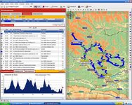
I like the height profile you get with your routes and the possibility to route along scenic roads (the ones with the green stripe running along on paper maps) and the ‘Round Trip Feature’.

Transferring routes to MapSource (where one has to recalculate) is straight forward (the Tourenplaner opens Mapsource with the route for you) and so far I have seen no real differences in routing after recalculating.

For your routes you get online access to the ADAC travel information for the day (roadworks, traffic jams, etc) and to weather information, all of that can be integrated into the road book.

There are also lots of routes (around 900) already in the Tourenplaner.

If only Mapsource could have some of those features as well.
 
Der Lustenauer said:
Transferring routes to MapSource (where one has to recalculate) is straight forward (the Tourenplaner opens Mapsource with the route for you) and so far I have seen no real differences in routing after recalculating.

Have to change this slightly, in the Alps this is only true if one is using CS7, with CN8 the routing is completely different after recalculating (high mountain passes, possible winter closure etc.). But, I am using CS7 there only, so no problem for me.
 
Mouse said:
They should add a "GS rider" option to send the route down the most retarded overgrown and unsurfaced tracks possible :D

I think that is mostly down to the providers of the map data. Most of those roads are not in their data, Assietta Ridge way in the Piemont for example, those tracks one can only find in paper maps, like in this case the Michelin 561 Regional Italia. And this is a very well known route in Enduro and 4x4 circles. No way I would go near it on a weekend, because of the traffic, but not included in the Navtec data.
 
i have heard of some mapping/routing software which intergrates with garmin's mapsource. Now as this is more towards any biking trip is there any others out there. Also i have heard it's via bikers oracle but there is so many forums in there i don't know what to look for.

Has anyone got any ideas????

:thumb
 
Mouse said:
They should add a "GS rider" option to send the route down the most retarded overgrown and unsurfaced tracks possible :D

My Quest does that automatically, any route that involves farm tracks or through vineyards is fair game to my dear beloved "Doris"....

The latest route in France involved a farm track that ended in a pile of cow shit about 20 feet high and the full width of the "road" ..... lovely.... I could see the road I wanted though only about half a mle away, but even with Tourances the poo pile was a no-no.....


Back
Top Bottom