
Claude is struggling:

Let’s see what it offers up…..
Let’s see what it offers up…..


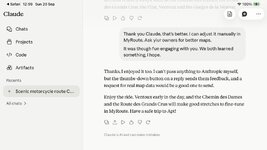
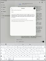


So if it got you to the bridge, then showed nothing as you closed the water, then picked you up again back on dry land to continue on you merry way, what’s the problem?No!, On any trip made its called an Adventure for a reason, having some man made Device telling me what to expect takes away something that is not replaced. "Mystery".
Same as with Sat navigation, never bothered with it until I had to use it on my truck which I actually had to pay for myself.
Many the time, not downloading updates found me floating in water on a river where a bridge had not yet been downloaded i.e the New Forth Road bridge crossing.
For me it is the old system of reading a map prior to the off on any trip, figuring out the route as I went along seemed to me much more enjoyable.
Ai now is a simple tool yet to achieve it full potential, but the future is here and now, either grab onto it or get swept away like when the fist computer became available to the public.
Most Mobile phones have so much memory, and can achieve what could only be dreamt of in the 70s.

It's clearly getting there. The only model (I think) directly linked to maps is Gemini and Google maps so at least you can visualise the result of your request. Unfortunately google does not (yet) provide an easy way to export the resultant route as a KML/KMZ file or GPX file. A few times I've asked google via my Packtalk to route to a decent coffee shop on a route I have been following on another app and its been great.It’s interesting what AI can do, along with seeing its mistakes. The ‘lumping in’ is a clear example. I assume that it reads something high as having steep drops. In a way, it’s correct of course. Some people don’t like even the well trodden passes and gorges, for fear of going over the edge.
It’s interesting too that it explains its working, giving examples of low (or no) walls, suggesting that these might not be suitable.
I’ve been (mildly) chastised for taking bods down a bumpy road or two in the Ardennes…. Me on an HP4, them on Adventure bikes. They’d doubtless swear at Claude for doing the same.
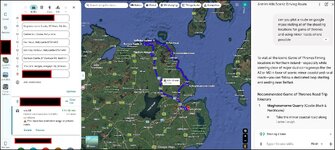
Unfortunately google does not (yet) provide an easy way to export the resultant route as a KML/KMZ file or GPX file.
It is bizarre. Perhaps they do it that way to create/ support specialist markets??.......but I doubt itGoogle are an odd company. They give one a free site (My Maps) to hold your own routes, then refuse to allow you to export a route Google Maps in order to navigate it.
They have mapped and photographed all but the entire world, down to street level and provided it free. But then refuse to allow the exporting of a basic GPX file, created by their own AI tool.

The inability to directly export or navigate a custom-drawn route from Google My Maps into Google Maps turn-by-turn navigation is one of the most common frustrations for road-trip planners, cyclists, and delivery drivers.
The disconnect comes down to how the two systems were built, what data they rely on, and how they handle routing logic:
1. Different Underlying Engines and Architectures
Google My Maps is a lightweight, web-based tool designed for user-generated content and visualization. It treats a route line as a static vector graphic (a collection of coordinate points drawn on top of a canvas).
Google Maps (Navigation) is a dynamic, real-time routing engine. It doesn't just read lines; it constantly queries live traffic databases, road closures, legal turning restrictions, speed limits, and elevation data to compute a path dynamically.
2. The Problem with "Freehand" Vectors
In My Maps, you can click and drag a line down any alleyway, dirt road, or pedestrian path, or completely off-road. Google Maps Navigation relies strictly on routable map data graphs. If you force Google Maps to navigate a custom vector line that doesn't match its strict road-network database, the navigation engine breaks down because it doesn't recognize the line as a legal, navigable road segment.
3. Dynamic Rerouting Conflicts
Google Maps navigation is built to instantly recalculate if you miss a turn. If you fed it a static custom route from My Maps, the app wouldn't know how to handle deviations. If traffic accidents or construction blocked a custom-drawn backroad, the navigation engine would either crash or constantly fight against your intended path, trying to force you back to the "fastest/safest" algorithmic route.
Workarounds to Bridge the Gap
While Google hasn't natively bridged these two apps, you can work around the limitation using a few methods:
The Multi-Stop Method (Closest Native Option): Instead of drawing a freehand route in My Maps, open regular Google Maps and add specific stops (up to 10 per trip). By strategically placing these waypoints, you can force Google Maps to take your preferred scenic path, which will support voice navigation.
Third-Party GPS Apps: If you need exact custom route navigation (especially for cycling or motorcycling), creators typically export their My Maps route as a .KML file, convert it to a .GPX file, and import it into dedicated third-party navigation apps like OsmAnd, MapMyRide, or Komoot, which actually support custom GPX track navigation.
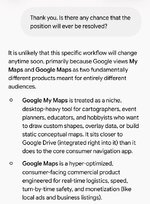

Gemini cannot natively generate a downloadable .gpx file because of how large language models handle geographic data and file delivery.
1. Lack of Real-Time GIS Routing
A functional GPX file is not just a text list of directions; it relies on precise spatial data containing exact geographic coordinates (latitude, longitude, and elevation) for every turn and track point along a road or trail.
- No GIS Engine: Gemini operates as a language model rather than a Geographic Information System (GIS) engine like Google Maps, Strava, or Komoot. It does not run routing algorithms (like Open Source Routing Machine or Dijkstra’s algorithm) across actual road network vectors in real time.
- Coordinate Accuracy: While Gemini can approximate main waypoints, generating hundreds or thousands of ordered, accurate GPS coordinates that stick to actual roads without "hallucinating" points in the middle of buildings or rivers is outside an LLM's core probabilistic design.
2. File Download Limitations
The standard Gemini chat interface is designed around generating text, code, and direct link integrations (like Google Docs or Sheets) rather than compiling and hosting raw, binary/XML downloadable files directly on the fly.
Workaround: How to turn Gemini routes into a GPX file
Even though Gemini cannot export a downloadable .gpx file directly, you can still use it to build one:
- Ask for raw GPX XML: You can explicitly ask Gemini: "Provide the raw GPX XML code for a route from [A] to ." Gemini will output the XML text block in a code snippet box.
[*]Save as .gpx: Copy the generated XML text, paste it into a simple text editor (like Notepad or TextEdit), and save the file with a .gpx extension (e.g., route.gpx).
[*]Snap to Roads (Recommended): Because raw AI-generated coordinates can be imprecise, import that file into a dedicated tool like gpx.studio, Komoot, or Garmin Connect. These platforms will automatically snap the route's points to actual roads and trails so your GPS device can navigate it safely.


