Steve R
Registered user
'86 G/S Paris Dakar, TKC80s @ 26psi, loaded panniers, Garmin Zumo 550, no mates (as usual). Stopover in Alston (not really necc.)
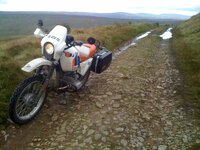
Image 1. Coldberry End - connects Teesdale and Weardale - highest road in England - 681m. Done it before in VW camper and Fiat Panda, first time on a GS. Easy. Roughest at the southern end, would suggest south - north crossing.
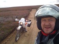
Image 2. Blanchland Moor, south of Hexham in Northumberland, easy track, bit of sand in the middle, no problem, even for bigger GS.
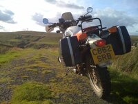
Image 3. Byway between Alston and Nenthead, Cumbria. An offshoot to the left was the only time I had to turn around. Could have got down but might not have got back up if the trail was blocked further on.
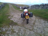
Image 4. Cam High Road above Bainbridge, Yorkshire Dales (4.5 miles long). Easy. All GSs should be forced to traverse this road as a bare minimum.
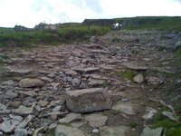
Image 5. Stalling Busk to Cray. Great track. Do it north - south but be prepared for a serious rocky descent near the end. I had to move a few rocks and memorise the correct line down before riding it. The 6 4x4s after me all had to stop and do a bit of work on the track to get down. TKC80s and some off-road experience required.
Fancy a proper Pennine Way next - start with Ingram to Prendwick in Northumberland, then Keilder Forest Drive (gravel), Blanchland Moor, Coldberry End, Cam High Road, Summer House then one or two in Derbyshire, finishing near Edale, the end of the Pennine Way. All in one day. 187 miles in 3hr 47min if you stick to the M1/A1. A lot longer using my route.
Steve.
Image 1. Coldberry End - connects Teesdale and Weardale - highest road in England - 681m. Done it before in VW camper and Fiat Panda, first time on a GS. Easy. Roughest at the southern end, would suggest south - north crossing.
Image 2. Blanchland Moor, south of Hexham in Northumberland, easy track, bit of sand in the middle, no problem, even for bigger GS.
Image 3. Byway between Alston and Nenthead, Cumbria. An offshoot to the left was the only time I had to turn around. Could have got down but might not have got back up if the trail was blocked further on.
Image 4. Cam High Road above Bainbridge, Yorkshire Dales (4.5 miles long). Easy. All GSs should be forced to traverse this road as a bare minimum.
Image 5. Stalling Busk to Cray. Great track. Do it north - south but be prepared for a serious rocky descent near the end. I had to move a few rocks and memorise the correct line down before riding it. The 6 4x4s after me all had to stop and do a bit of work on the track to get down. TKC80s and some off-road experience required.
Fancy a proper Pennine Way next - start with Ingram to Prendwick in Northumberland, then Keilder Forest Drive (gravel), Blanchland Moor, Coldberry End, Cam High Road, Summer House then one or two in Derbyshire, finishing near Edale, the end of the Pennine Way. All in one day. 187 miles in 3hr 47min if you stick to the M1/A1. A lot longer using my route.
Steve.