kevingrahambutler
Registered user
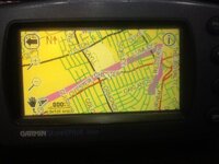
I update the maps on open street maps to my 2610 all works fine switch it on pluged into car for test run all works fine the black marker sticks to the road as it shoulda round the street, program a route into the unit and the pink line that should lead round the streets to your designation only goes in a straight line, so it will not navigate what have I done,,,, any help would be greatfull