Ravenbyrne
Registered user
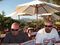
Great photo's Jochen, looks like your having a fantastic time


Currently in Three Rivers, CA, just south of Kings Canyon / Sequoia

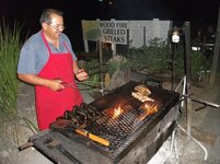
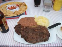
TwiceI hope you enjoyed the steak in the Sequoia Cider Mill restaurant.

")

I hope you enjoyed the steak in the Sequoia Cider Mill restaurant.
superb steak, refried beans and mashed taters....
I remember you did Aidan


Anyway.


 (I don't go around checking under beds - I only know cos I was looking for a socket) And the shower was filthy too
  It's the second dirtiest place I've ever stayed in. As you ask, the dirtiest was a 'hotel' in Demnate, Morocco but that was $8 rather than last nights $80.


 sample :


 A few tetchy moments ensued before common sense prevailed & we all realised we'd no choice but to do the extra miles. I was just glad that navigation was my gig, not accommodation. It was just one of those things...
 Luckily it was only short sections but I've no idea how Liam & Nigel coped with passengers. Once into the park it changed to corrugations / washboard & we thought that was the worst, until we got to the bit of washboard with sand in the corners


Offroad and art in the one report. My cup runneth over
Still nowhere near the standard you set for picturesOffroad and art in the one report.

Yeah, sorry about that. I'm finding it very difficult to cut down the number of pictures I'm posting & they must seem very repetitive to those reading the posts but I just find some / much of the scenery stunning and, to use a very over used word, "awesome". Actually, 'awe inspiring' would be a better fit.All our cups runneth over
I'll try & exert a bit more self control
I fly out next Monday for the first Alaska trip so it's just wetting my appetite.Fair enough. Just thought I was over doing it a bit.Don't do that mate, I love seeing pictures of my spiritual home
Lucky you ! Enjoy it ChrisSgt Bilco said:I fly out next Monday for the first Alaska trip so it's just wetting my appetite.