Basecamp for complete Numpties

Stonker

Registered user
Joined
Nov 14, 2009
Messages
966
Reaction score
0
Location
Not far away
OK, so I've just bought a Zumo 660 and learnt the very basics. I'm going away this week so have an opportunity to give it a propper test. I have downloaded Basecamp have set it to 'Motorcycle', tried to use the 'find feature' to find 'Calais' (I know how to get that far!) but failed miserably. I thought that if there's somebody that can talk me through the basics (and we can stay on topic (please), it might help other so get started.

Any volunteers?
 
Don't use motorcycle - it sends you everywhere :mad:

Set it as automotive.

Put your start and end points in as waypoints. You can edit the image. These should appear in 'my collection'.

Go to create route and drag these in. This creates a route which you can then play with by using the selector tool to drag it around to where you want.

NOTE: Be careful when dragging you get it exactly on the road or you will be sent down the local avenue. Zoom in to make sure.

Just been planning a few routes this morning. The find feature is shite :mad::mad:
 
'Put your start and end points in as waypoints.'

That's where I struggled. I selected 'new route' and it told me to drag and drop them. I have a map of the world on the screen so where do I drag them from. Do I need to zoom and move the map around?
 
'Put your start and end points in as waypoints.'

You should have a toolbar at the top which includes Waypoint Tool.

Get you map zoomed to your required area, click the Waypoint Tool and the mouse icon will change to a blue flag which will land where you opt to click on the map.
 
OK, I've clicked on the zoom tool (the magnifying glass) and am now zooming in to the bay of biscay....very useful. Now, how do I re-center the map? (trying to pick it up like google maps doesn't work as it zooms more)
 
Don't worry....I've done that...you hover over the blue triangleon the map and click on the arrow buttons

I have a flight on the map going from Canada to Lille (where I was frigging about yesterday. How do I delete that?
 
Will post more this evening, regrettably weekends are not my own.

I've warmed to Basecamp lately. There are some settings that need to be made to make the bike profile behave, both in Basecamp and on the Zumo.

As stated elsewhere; if you're new to Garmin route planing on your PC then Basecamp is the way to go.

Sent from my GT-I9100 using Tapatalk 2
 
Has basecamp now superseded mapsource?

Looks like it as it works on both PC and Mac. Mapsource will no longer be updated/supported according to Garmin.
There are some easy to understand instructional videos with Basecamp, if you have ticked the box to stop the welcome pop up with a link to these then they can be found by clicking on the "help" tab and then "video tutorials". Each one is only a couple of minutes long but very informative and well worth watching to pick up the basics.
I hated Basecamp when I first used it but am warming to it now I'm learning what it can do:thumb2
 
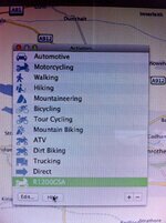
Rather than using the generic 'Motorcycling' one as is, it can be edited or a custom one created and the various boxes ticked or unticked.
I've not found problems using the Motorcycling option as against the Automotive as supplied. But to be fair, I'm not sure exactly what ticking/unticking some options may have on the roads here or in Europe - as against the good ol' US of A.
I noticed when I made the GSA one that in the options, initially Ferries were ticked as an avoidance. I guess that could cause a bit of chaos in places like Holland or Sweden.
Need to look carefully at what it selects on an A-B-C-D route on the standard setup vs the options I've selected.
Usually I just put in the next B&B on the Zumo and see what it spits out...
 

Attachments

  • IMG_3529.jpg
    IMG_3529.jpg
    96.3 KB · Views: 509
Note that you can view your variations of the route by showing an animation, selecting your route from the list on the left pane.


Right-click a route or a track, or press and hold Control while clicking a route or track. (From left pane; not by clicking on the line of the route/track on the map.)
Click Play Route or Play Track.
Use any of the following options to control the animation:
Click Pause to pause the animation.
Click Play to start or resume the animation.
Click Loop to toggle whether the animation will start over or stop at the end of the route or track.
Drag the top slider to move forward and backward in the route or track. The progress indicator shows the current position on the map.
Drag the bottom slider, or click Slower and Faster to adjust the speed of the animation. To enter a specific speed, enter a value in the box next to x Actual Speed. A value of 1.0 plays the route or track at actual speed.
 
As ghiribizzo has mentioned it's a matter of tailoring the profiles to suit your use.

One of my major frustrations with Basecamp was when I'd imported a route that I'd previously created in Mapsource I would want to have this in the motorcycle profile, well, I ride a bike so why not... Having just got a Zumo 660 that flips into the motorcycle profile as soon as you pop it into the bike cradle this became even more relevant.

Regrettably, in Basecamp, any of my previously carefully crafted Mapsource routes went totally hay-wire once the motorcycle profile was used in a recalculation. At this stage I cursed the Garmin development team that had tried to make Basecamp too clever and returned to the comfort blanket that is Mapsource. This all worked fine with my 'bikeised' Nuvi 765T and I was happy... a little frustrated, but happy...

Playing, and getting familiar, with my new 660 I loaded some routes for a forthcoming tour and ran one in simulation mode. I tried various things including a recalc. To my horror it changed the route out of all recognition. This was whilst it was in the motorcycle profile.

I started to look into this deeper and discovered that you could adjust the profiles, both in Basecamp and on the Zumo, independently of each other adding/removing different avoidances. The default settings for the automotive and motorcycle profiles, both on the GPS and Basecamp, were wildly different.

Any routes, created by other programs, imported into Basecamp have a profile called 'None' applied. The car profile is pretty close to this, the motorcycle profile has some significant differences.

For my use I'm happy with the standard automotive settings, it's what I'm used to. If I let the GPS decide the route for me and wanted it to avoid main roads (terminology is actually American so they say Major Highways, State Highways, Interstate etc.) then I can still set that if I want it. However, in the main, I use PC planned routes and set-up these up to follow the roads I want. I don't want the GPS interfering with this. However, unlike some, I prefer having auto recalculation on and expect my Garmin to only get me back onto my intended route and not totally change the rest of the route. To date my various Garmins have done this very satisfactorily.

Imported route, as it should be. Opening options menu to view profile settings
automotive-route.png


Automotive profile settings
automotive-profile.png


Motorcycle profile (not sure on exact default settings but you get the idea)
motorcycling-profile.png


Recalculating the route by changing the profile from None to Motorcycle
change-profile.png


Route recalculated with the motorcycle profile (pretty messed up)
motorcycle-route-bad.png


Having adjusted the bike profile to the same as the car profile and then recalculated
motorcycle-route-good.png


The settings on the Zumo are similar, you need to set each profile and then 'Tools' > 'Settings' > 'Navigation' > 'Avoidances'. You then check/un-check the boxes as required. Again running similar settings to Automotive should work. I just have un-paved roads checked on my bike profile, all others un-checked.

If you want to change these on the road then do so and then recalculate the route. i.e. if you wanted to avoid toll roads.

U turns iare always a tricky one as sharp hairpins are sometimes seen as U turns by Garmins, setting these up as an avoidance could play havoc with a decent biking route.

 
I can see that perhaps working around a known route on home turf with the various options may be an advantage given the points you mention.
Tonight I found some weird things happening trying to plot a route through Denmark to Sweden and after it looked ok-ish and some routes were transferred to the 660 it came up with the classic "routes have been calculated with different Maps - do you want to recalculate?"
Yet the same 2013 map was selected on the mac and 660.
The only thing I can think of with that is that both the CN and 3D maps are selected on the 660 but I was looking at the regular CN map on the Mac.
Another day...
 
I don't think the 3D maps have any influence over routing. They're just the 3D landmarks/buildings, nothing (that I'm aware of) to do with the road network. Your GPS can work quite comfortably without that file. GMAP3D. IMG

Sent from my GT-I9100 using Tapatalk 2
 
OK, can I get back on topic now?

How do I set up a route to get me from Calais ferry port to my hotel in Belgium? Do I set up a new route or waypoints?
 
click on the Route button.

click on your start point (calais).

click on end point (your hotel). basecamp will calculate the route.

if you don't like the route taken, click on the Arrow (cursor) button. left click on the created route and drag it where you want. repeat as necessary.
 
If I click on 'new'>'route', it asks me to drag my waypoints in but I can't drag anything


Back
Top Bottom