


Re the OP’s question about the easy way to load on OSM map of Morocco (ideally with contour lines) onto my Zumo XT, I’ve developed a set of free OSM-based Garmin maps for adventure motorcycling that includes Morocco (and has 100m contour lines).
They are now listed on the Wiki: https://wiki.openstreetmap.org/wiki/OSM_Map_On_Garmin/Download
Just copy one or more map files to the Zumo’s SD card into a folder called “Garmin” in the root directory. You don’t need to rename the files.
If you connect the SD card to your PC, Basecamp will open them automatically. You can see far more detail in Basecamp than in a Zumo because the highest detail setting (“More”) is only equivalent to "Medium" in Basecamp.
For example, Casablanca in my Zumo XT on "More":
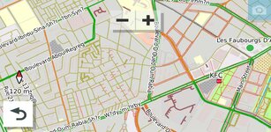
It looks like this in Basecamp on "Medium":
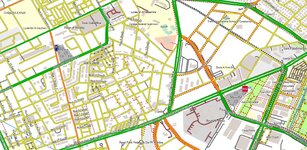
It looks like this in Basecamp (and in handheld Garmins like Oregons, but not Zumos and not Nuvis) on "High":
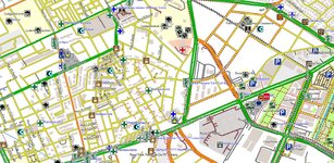
I was very surprised to find that Garmin does not include a "High" or "Highest" setting in a Zumo so that it can show on the screen all the detail that is actually inside the map, the way that the handhelds like the Oregon, Colorado, and Montana can be set show all the detail, not only details like viewpoints but the surface, width, grade, and ford warnings I built into these maps. They are clear in Basecamp and in my 2008 Oregon but invisible in my 2022 Zumo.
The direct link to the maps is here, with examples, the legend, and easy instructions:
https://rex8475.wixsite.com/advosm
Enjoy the maps.
=======
I have copied this post over from the GPS section.
Richard
They are now listed on the Wiki: https://wiki.openstreetmap.org/wiki/OSM_Map_On_Garmin/Download
Just copy one or more map files to the Zumo’s SD card into a folder called “Garmin” in the root directory. You don’t need to rename the files.
If you connect the SD card to your PC, Basecamp will open them automatically. You can see far more detail in Basecamp than in a Zumo because the highest detail setting (“More”) is only equivalent to "Medium" in Basecamp.
For example, Casablanca in my Zumo XT on "More":
It looks like this in Basecamp on "Medium":
It looks like this in Basecamp (and in handheld Garmins like Oregons, but not Zumos and not Nuvis) on "High":
I was very surprised to find that Garmin does not include a "High" or "Highest" setting in a Zumo so that it can show on the screen all the detail that is actually inside the map, the way that the handhelds like the Oregon, Colorado, and Montana can be set show all the detail, not only details like viewpoints but the surface, width, grade, and ford warnings I built into these maps. They are clear in Basecamp and in my 2008 Oregon but invisible in my 2022 Zumo.
The direct link to the maps is here, with examples, the legend, and easy instructions:
https://rex8475.wixsite.com/advosm
Enjoy the maps.
=======
I have copied this post over from the GPS section.
Richard
Last edited by a moderator:





