Thats what I am doing but its pita, The mapping does similar on the Stilfserjoch pass , the only similarity i can see is happens near country borders, yet it crosses other borders without issue.There is probably a break in the mapping somewhere. Easiest way would be to create a route to the break then another from the break. Not familiar with Tyre though.
I know the route reasonably well , Its our run towards Ferry for European trip.Looking at the open cycle map in MRA it looks like it wants you to take a run round the forest!! View attachment 316559
Nice run that down Towards Kielder as is the Parallel road from Hawick that runs down past Hermitage Castle. Hope you get sorted.
I can easily work around the problem, but thought it was possibly something i was doing wrong.It is not too clear what sort of road / track that is.
Some software makes a detour if a road is known to be shut. Or, possibly, as above, the map is incomplete for some reason or other. In MyRoute or BaseCamp you could probably force the route along the break, if it is really important to you. Or, just do as suggested, and break the route into two parts; you are unlikely to get lost over that short section.
")
I can easily work around the problem, but thought it was possibly something i was doing wrong.


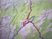
Looking at your route on the Ordnance Survey map, the road from Saughtree to Meredykes appears unadopted/unfenced, so maybe (just maybe) Tyre thinks you shouldn’t ride them?Im having issues where my routing refuses to go beyond a certain point and takes a large detour.
The example is on Tyre . Any ideas how to sort this ?

Looking at your route on the Ordnance Survey map, the road from Saughtree to Meredykes appears unadopted/unfenced, so maybe (just maybe) Tyre thinks you shouldn’t ride them?
Also, the Tyre mapping route is trying to take you along an old dismantled railway track
Im having issues where my routing refuses to go beyond a certain point and takes a large detour.
The example is on Tyre . Any ideas how to sort this ?
I wish him all the luck in the world, thenThe gist I get is that the fellow might be on a pushbike.
No that was me confusing the issue. The cycle map was the only one on MRA that displayed the tracks the wonky route the OP posted displayed.The gist I get is that the fellow might be on a pushbike.