

You are using an out of date browser. It may not display this or other websites correctly.
You should upgrade or use an alternative browser.
You should upgrade or use an alternative browser.
the celt
Registered user
- Joined
- Dec 30, 2002
- Messages
- 3,308
- Reaction score
- 15
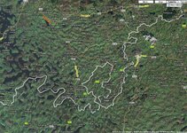
Just having a look at Google maps before I depart for County Fermanagh for the weekend.
Spotted this oddity on the border, an enclave of the South pushing into County Fermanagh.
Whats that all about then boys?
To confuse the Brits

Deleted account W
Guest
Gizmo
Registered user
Strange indeed
Its a long story concerning Ulster being 9 counties but only six remaining within the UK.
At a guess I would say that the boundary was drawn this way to ensure that nationalists did not have an electoral majority in that region when the partition of Ireland happened in 1922. There was a real risk then that a plebicite within a 9 county Ulster would vote to stay within Eire, so the electoral divisions were drawn carefully to ensure this did not happen.
Some would call it gerrymandering, others would say it was done to avoid the real possibility of Unionist/Nationalist conflict.
The rest as they say is history!!!
Just having a look at Google maps before I depart for County Fermanagh for the weekend.
Spotted this oddity on the border, an enclave of the South pushing into County Fermanagh.
Whats that all about then boys?
Its a long story concerning Ulster being 9 counties but only six remaining within the UK.
At a guess I would say that the boundary was drawn this way to ensure that nationalists did not have an electoral majority in that region when the partition of Ireland happened in 1922. There was a real risk then that a plebicite within a 9 county Ulster would vote to stay within Eire, so the electoral divisions were drawn carefully to ensure this did not happen.
Some would call it gerrymandering, others would say it was done to avoid the real possibility of Unionist/Nationalist conflict.
The rest as they say is history!!!
the celt
Registered user
- Joined
- Dec 30, 2002
- Messages
- 3,308
- Reaction score
- 15
Well it's worked
Any way that google map is out of date....
The boarder is no longer painted grey...
Its now a nice pale red, some even call it pink.
You cant miss it....
and if your luck enought you might even see
aul Jack O'Shea at work who paints it yearly
by hand, lovely aul fella, the stories he can tell....
bsogri
Registered user
border
It will be interesting to find out, why not ask the friendly locals, anyway have a good time and look after James and Suzy[keep her off the bar] and yourself of course.
It will be interesting to find out, why not ask the friendly locals, anyway have a good time and look after James and Suzy[keep her off the bar] and yourself of course.
nud1e
Registered user
Just having a look at Google maps before I depart for County Fermanagh for the weekend.
Spotted this oddity on the border, an enclave of the South pushing into County Fermanagh.
Whats that all about then boys?
Mistaken you are.
Not a southern enclave but two northern enclaves pushing into Co.Monaghan.
I know a postie who used to work that area, from the Monaghan side and would clock up serious overtime because of all the times he got stopped on the NI side. It was absolutely impossible for him to cover his route without crossing and recrossing the border several times a day.
A similar peninsula of Limerick sticks into Tipp near Emly.
A similar peninsula of Limerick sticks into Tipp near Emly.
Read a story about Belleek when researching stuff for the Kesh WW2 Flying Boats run. The border runs through the town and during the war, the left hand (UK) side of the street was blacked out but the lights in all the pubs in the( Neutral) Irish Republic side were blazing away. Only in Ireland 
GSless Girl
Registered user
Read a story about Belleek when researching stuff for the Kesh WW2 Flying Boats run. The border runs through the town and during the war, the left hand (UK) side of the street was blacked out but the lights in all the pubs in the( Neutral) Irish Republic side were blazing away. Only in Ireland
We had to keep priorities right in case we spilt any

Decster
Registered user
- Joined
- Apr 25, 2005
- Messages
- 8,123
- Reaction score
- 2
Read a story about Belleek when researching stuff for the Kesh WW2 Flying Boats run. The border runs through the town and during the war, the left hand (UK) side of the street was blacked out but the lights in all the pubs in the( Neutral) Irish Republic side were blazing away. Only in Ireland
The border runs through the wee town of Pettigo in Donegal/Fermanagh.....

JimmyC
Registered user
The border runs through the wee town of Pettigo in Donegal/Fermanagh.....
Anybody know the name of the man standing on the plinth in the middle of the town???????????????????????
Just a wee teaser..............................

Don't be sayin' anything about him.............
>
>
>
>
>
>
>
>
>
>
He's a relative of mine...............
Tengiz99
Registered user
Pretty simple, the border follows the county boundaries. No straight lines in Ireland. (Apart from the roads the Germans funded).
the celt
Registered user
- Joined
- Dec 30, 2002
- Messages
- 3,308
- Reaction score
- 15
He's a relative of mine...............
Are yer sure its not yer man layin down ???

Captain Jack Sparrow by any chance ???
or could it be...
<object width="425" height="344"><param name="movie" value="http://www.youtube.com/v/7_mol6B9z00&hl=en&fs=1"></param><param name="allowFullScreen" value="true"></param><param name="allowscriptaccess" value="always"></param><embed src="http://www.youtube.com/v/7_mol6B9z00&hl=en&fs=1" type="application/x-shockwave-flash" allowscriptaccess="always" allowfullscreen="true" width="425" height="344"></embed></object>
electric_monk
Registered user
The skull and crossbones on a headstone is a freemasonry motif...
Are yer sure its not yer man layin down ???
Captain Jack Sparrow by any chance ???
or could it be...
<object width="425" height="344"><param name="movie" value="http://www.youtube.com/v/7_mol6B9z00&hl=en&fs=1"></param><param name="allowFullScreen" value="true"></param><param name="allowscriptaccess" value="always"></param><embed src="http://www.youtube.com/v/7_mol6B9z00&hl=en&fs=1" type="application/x-shockwave-flash" allowscriptaccess="always" allowfullscreen="true" width="425" height="344"></embed></object>

Similar threads
- Replies
- 31
- Views
- 7,531
- Replies
- 36
- Views
- 25,519