When you tossers were much younger…

EVskiy

Hand-crafting clients' ideas in real time
UKGSer Subscriber
Joined
Mar 27, 2016
Messages
10,776
Reaction score
4,809
Location
Hertfordshire
… way before the advent of interweb, how did you do your jaunt planning, I know a paper map would have been a must, but what about planing a 10 day Euro Jaunt to Italian Lakes in lest say 80’s - 90’s??? What was your strategy back then before the advent of all singing all dancing and flashing like a Christmas tree GS’s, festooned with navigation devices, mobile phone cameras, heated clothing etc, etc?

With the amount of Hotels on websites now it is much easier to just book a day ahead, or even stop at lunch time and find a room, the amount of smaller gaffs on booking / hotel sites has exploded, and internet access is much easier to get than 10-15 years ago, sadly I think there are less hotels and B&B's now though.

I am mere novice, a sprog where travel planing is concerned.

My first Euro Jaunt on the bike was 10 years ago. In a car a couple of years prior (we used AirBnB. Before that, around 2006, wife (girlfriend at the time) and I crossed the Chunnel on the Dover-Calais ferry and drove to Holland for a long weekend away with a A3 sized Collins Road Atlas firmly in her grip, which she turned around more times than I did the steering wheel for the duration of the entire trip 🤣. We truly did wing it then. On our first night we failed to find a camp site, so ended up pitching a tent in the dark in the middle of the farmers potato field, got woken up by ever increasing passing motorway traffic and bunnies hopping about the place. We literally did point the finger at the map, “that looks a nice place” and drove to it, praying to the Lord that there would be a campsite with available pitches. It worked to a degree, but we were young, and deeply in love as we still are, even though on occasion the relationship can feel coarser than P40 grit sanding paper.

Today, I plan and book my/our trips in as much detail as I can, without it being overly polished or practically every inch inspected on Google street view. Naturally it is so much easier with the likes of Booking.com or Hotels.com (preferred provider for one of many reasons), not least the guidance devices become so easy to use, rendering paper map almost useless. I still like a paper map though, for the purposes of general overview on a larger scale. I also like to look and poke my finger about said maps, you can get a general idea of distances between cities/towns/junctions without having to plot the same route in google maps or similar in order to find out overall distances for particular leg.

I am keen to hear your tales and Adventure mishaps, so please share away, don’t hold it back, this could be a right giggle for many of us, not least youngsters like me, will have a better understanding what it really meant to be going a way on a two week long bike trip to Euroland.

Thanks in Advance.

Ev
 
Last edited:
Before the internet there was a handy booklet called Hotels Abroad. On my first Euro jaunt in 1995 with a mate we used that to book hotels such as a base for a week near Grenoble.
We got the overnight P&O ferry from Portsmouth to Le Havre.
I bought the Rough Guide to France which told me about the Massif Central and most scenic Cols in the Savoy Alps, which was largely the Route des Grandes Alpes. So we did Cormet de Roseland, Galibier, Iseran, Bonnette, Mont Cenis etc. all in loops from the Grenoble base.
On the way down we stopped in Montlucon and then rode up the Puy de Dome in the Volcanes part of the Massif Central. You can't ride this road now.
I planned the routes using the 1:200,000 Michelin Maps, then with yellow cover. Directions were written on paper inserted into the tankbag window. Finding prebooked hotels was fun and games sometimes even with supposed directions from the booking agent.

We did another trip to Slovenia in 1999, although we outsourced some hotel booking to MCiTours. All navigation was using paper maps and notes. We had to find our own hotels on the way back and that was when I fell in love with Trier. It was pissing with rain so I just followed a sign for Centrum to hopefully find somewhere to eat whilst the storm blew over. This is when I found that Germany is much like the UK in that the local tourist office will find you a hotel. We ended up staying 2 nights as there was a wine festival on.

I did not have a satnav until around 20 years ago when I bought one of the last Garmin 2610. That was replaced with my current Zumo 390 in 2015! I like to get my money's worth out of technology.
 
Before the internet there was a handy booklet called Hotels Abroad. On my first Euro jaunt in 1995 with a mate we used that to book hotels such as a base for a week near Grenoble.
We got the overnight P&O ferry from Portsmouth to Le Havre.
I bought the Rough Guide to France which told me about the Massif Central and most scenic Cols in the Savoy Alps, which was largely the Route des Grandes Alpes. So we did Cormet de Roseland, Galibier, Iseran, Bonnette, Mont Cenis etc. all in loops from the Grenoble base.
On the way down we stopped in Montlucon and then rode up the Puy de Dome in the Volcanes part of the Massif Central. You can't ride this road now.
I planned the routes using the 1:200,000 Michelin Maps, then with yellow cover. Directions were written on paper inserted into the tankbag window. Finding prebooked hotels was fun and games sometimes even with supposed directions from the booking agent.

We did another trip to Slovenia in 1999, although we outsourced some hotel booking to MCiTours. All navigation was using paper maps and notes. We had to find our own hotels on the way back and that was when I fell in love with Trier. It was pissing with rain so I just followed a sign for Centrum to hopefully find somewhere to eat whilst the storm blew over. This is when I found that Germany is much like the UK in that the local tourist office will find you a hotel. We ended up staying 2 nights as there was a wine festival on.

I did not have a satnav until around 20 years ago when I bought one of the last Garmin 2610. That was replaced with my current Zumo 390 in 2015! I like to get my money's worth out of technology.
Thank you for sharing Wessie.

What was it like in ‘99 riding to Slovenia, am assuming you had to apply for a visa months in advance, or was it fairly straight forward border crossing then, I guess not to dissimilar apart from it being unmanned today?
 
Lonely Planet.
I was probably better at planning with that, than now :)

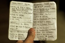
When I moved to London, and bought the boxercup, first trip to Italy I used a car tomtom stuck in a little Givi bag. That was my first time traveling with a GPS. I expected it to fail (it did) so I had backup:

IMG_6608.jpeg
 
Last edited:
Thank you for sharing Wessie.

What was it like in ‘99 riding to Slovenia, am assuming you had to apply for a visa months in advance, or was it fairly straight forward border crossing then, I guess not to dissimilar apart from it being unmanned today?

No visa needed. Just a passport check. No other documents requested. It was an EU accession country and they had joined the European insurance thing (predates the EU by many decades) so no Green Card needed. Going back into Austria, there was a big queue at the Karawanken tunnel. Once the Austrian border guards saw out GB stickers we were waved to the front and through passport control quickly.

We did the same in 2003 going to Croatia as an accession country, no visa, no green card needed. Didn't have satnav for that trip either.

Look at your insurance now and they are including the latest batch of EU Accession countries like Bosnia and Serbia.
 
No visa needed. Just a passport check. No other documents requested. It was an EU accession country and they had joined the European insurance thing (predates the EU by many decades) so no Green Card needed. Going back into Austria, there was a big queue at the Karawanken tunnel. Once the Austrian border guards saw out GB stickers we were waved to the front and through passport control quickly.

We did the same in 2003 going to Croatia as an accession country, no visa, no green card needed. Didn't have satnav for that trip either.

Look at your insurance now and they are including the latest batch of EU Accession countries like Bosnia and Serbia.
Very interesting indeed. Thank you for sharing.
 
I remember Microsoft's autoroute arriving in the 1990's, the first time I used a computer programme for planning and printing out maps for the tank bag, made a difference to just sticking the route directions on a tank bag and following the road signposts - that's what they're for after all :)

Autoroute was really quite versatile, missed it when they stopped it
 
I remember Microsoft's autoroute arriving in the 1990's, the first time I used a computer programme for planning and printing out maps for the tank bag, made a difference to just sticking the route directions on a tank bag and following the road signposts - that's what they're for after all :)

Autoroute was really quite versatile, missed it when they stopped it
Never did I hear about it. News to me.
 
Care to elaborate a bit?
I should have a picture of it, I will find it.
It was a bog standard car TomTom One. It powered via the car’s cigarette lighter, so I had it wired to the bike via the AUX socket, but that failed with rain on the way.
It was fixed to the bike via this semi-waterproof fabric pouch from Givi.

All the previous years I traveled across Europe with paper maps (as everyone else) on my previous bike, so not a massive issue.

I used to have a tank bag with maps and turn by turn instructions in the transparent pocket.
I traveled a lot with my ex by bike. We would plan fairly longish vacations based on itineraries off Lonely Planet suggestions. One trick was to ask the Hotel we were leaving to book the next hotel we wanted to stay in, and especially when traveling through Germany, etc.

I think we tend to underestimate how helpful GPS navigation is, these days.
 
Map, sheet of paper, pencil, a Michelin red book of hotels and their associated green (cultural) guide.

A smattering of assorted local currencies, no travel or breakdown insurance, some degree of currency control from the UK, sometimes some travellers’ cheques (assuming we were flush), tent, ill suited clothing.

I remember phone cards starting (first find a suitable phone box) and my first GPS device, predated Garmin’s mainstream arrival.

Patience at some / many border crossings.

A big sense of humour.
 
We’re (me & ex) started touring in about 1990-ish on a Kwak ZX10 with huge Krauser panniers and topbox plus a 2-layer tankbag, ensuring space for enough clothes for a 6 month cruise on the QE2. Needless to say, only a small fraction actually got used.
Hotel accommodation courtesy of Formule 1, which were silly cheap in those days at about £14 a night with shared toilets and showers down the corridor, I seem to recall that the toilet flushed itself and sprayed the room as you exited, and my wife was terrified she’d be locked in there whilst it performed its self-ablution!
Routing was picking somewhere that sounded nice, Perigord was one, and writing down the main towns and N road numbers on a piece of A4 before shoving it under the clear pocket on your Baglux tank bag.
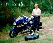
During one trip where we found difficulty in finding hotels we bought a cheap plastic tent from E.Leclerc supermarket and camped for the rest of the holiday. On return we bought a posh tent and all the trimmings, deciding that this would better suit our accommodation needs for the future, with the proviso that we’d hotel it every 3 or 4 days to get a proper shower and a decent nights sleep.
I didn’t start using satnavs until about 2003 (?) which made life easier, but even then I wasn’t planning routes, just sticking names in the satnav and being directed. It wasn’t until 2012 with a new bike and a new wife plus a 6 week tour of Europe that I used the MyRouteApp predecessor for the first time, locking into the satnav every twist and turn of our route. 4 days later we got caught in a rainstorm in Italy and the satnav broke down. Happily a coffee and cake in Valentino Rossi’s cafe kept us happy while the satnav dried out on the radiator… normal service was very happily resumed.
I still carry a map just in case, but age and comfort dictate the tent was passed onto my son.
PS - excuse the boots, they were cheap at the Frank Thomas tent at the BMF!
IMG_6185.jpeg
 
Last edited:
We only started bike touring about 20 years ago but it began with a Michelin map, a list of destinations and some cash. Nothing was pre-booked apart from the tunnel or ferry and a 'devil may care attitude'. At the time we were in our 40's but even now in our 60's we book as little as possible and make it up as we go along, the only difference is we have a smartphone to navigate and still book accommodation on the day.
 
Last edited:
Maps/Passport/Kit (tent as a back
Up) Eurocheques and cash
A rough plan and just stop at hotels as you went along
Youth hostels etc - aim for such & such a place and choose accommodation when you get there
 
… way before the advent of interweb, how did you do your jaunt planning, I know a paper map would have been a must, but what about planing a 10 day Euro Jaunt to Italian Lakes in lest say 80’s - 90’s??? What was your strategy back then before the advent of all singing all dancing and flashing like a Christmas tree GS’s, festooned with navigation devices, mobile phone cameras, heated clothing etc, etc?


I am mere novice, a sprog where travel planing is concerned.

My first Euro Jaunt on the bike was 10 years ago. In a car a couple of years prior (we used AirBnB. Before that, around 2006, wife (girlfriend at the time) and I crossed the Chunnel on the Dover-Calais ferry and drove to Holland for a long weekend away with a A3 sized Collins Road Atlas firmly in her grip, which she turned around more times than I did the steering wheel for the duration of the entire trip 🤣. We truly did wing it then. On our first night we failed to find a camp site, so ended up pitching a tent in the dark in the middle of the farmers potato field, got woken up by ever increasing passing motorway traffic and bunnies hopping about the place. We literally did point the finger at the map, “that looks a nice place” and drove to it, praying to the Lord that there would be a campsite with available pitches. It worked to a degree, but we were young, and deeply in love as we still are, even though on occasion the relationship can feel coarser than P40 grit sanding paper.

Today, I plan and book my/our trips in as much detail as I can, without it being overly polished or practically every inch inspected on Google street view. Naturally it is so much easier with the likes of Booking.com or Hotels.com (preferred provider for one of many reasons), not least the guidance devices become so easy to use, rendering paper map almost useless. I still like a paper map though, for the purposes of general overview on a larger scale. I also like to look and poke my finger about said maps, you can get a general idea of distances between cities/towns/junctions without having to plot the same route in google maps or similar in order to find out overall distances for particular leg.

I am keen to hear your tales and Adventure mishaps, so please share away, don’t hold it back, this could be a right giggle for many of us, not least youngsters like me, will have a better understanding what it really meant to be going a way on a two week long bike trip to Euroland.

Thanks in Advance.

Ev
/\ Maps maps maps, and cash .... I did a lot of camping out, but would occasionally get a room. So if you knew where you were going to be, which is still a thing, the you could use phone books, and the pay phone, to find out about booking somewhere. I never did that and relied on serendipity a lot. Sometimes you might even get lost. At a lot of state border crossings you would stop and get the map for that state which you kept in the tank bag, open to the relevant page. Canada could be tough, they check your background and may deny entry. I don't know if they still do that now. If you had a DUI on your record somewhere, they would deny entry, even for really old ones. I knew some canadian electricians that would come down and work in our locals. They said that it was because they didn't feel it was fair to canadians that had gone thru DUI's in their country. Apparently they didn't feel our punishment was adequate or severe enough. I don't know if that is a thing or not now ..... It stopped a couple of trips for me back in the day ....
But overall we would get by somehow back in the day. The breakdowns are the real scary things then imo. If it was real bad you would have to get to a phone somehow. I carried what I call a full enduro kit .... like spare controls cables, a clymer book for airheads, points condensers, spark plugs, spare tube for both wheels, air pumps, patch kits and on and on. And a fair amount of water just in case you got caught out in the sun with no one to help .... You should be ready to fix a flat, completely on your own. Which I did once with the airhead and many times with the xt500, something about trials tires, they seem to pick up nails all the time .... We were definitely on our own so to speak, but could possibly be helped by others who would offer help ..... I still carry stuff that I'm likely to need in fact to help some other rider more than myself, so we looked out for each other, many friends met this way. I have helped and fixed many problems out out on the road ......
 
Thank you for sharing Wessie.

What was it like in ‘99 riding to Slovenia, am assuming you had to apply for a visa months in advance, or was it fairly straight forward border crossing then, I guess not to dissimilar apart from it being unmanned today?
Not really

I did Eastern Europe in the 1990’s to Hungary and Czech Slovak and Slovenia & Croatia

You just rocked up at the Border and showed a British passport, sometimes it wasn’t needed even - they just saw the British number plate on your bike and waved you through to the front and just let you go through, nothing checked - I did that going into Ukraine in 1999

Hotels - you just did it on the fly …someone in Budapest told us about Hotel Golf in Prague (on the Pilzen road) - we just rode along from the city centre until we found it

It was very eastern bloc with remnants of the Soviet era - en-suite was a plastic pod capsule in the corner of the bedroom
You just changed money at the Border

Seems so long ago
 
Last edited:
Eurocheques

Petrol

Go


Sent from my iPhone using Tapatalk


Back
Top Bottom