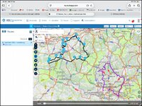
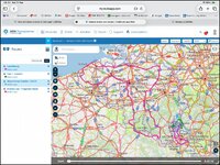
How do I show a track on the map?

Berin

Well-known member
UKGSer Subscriber
Joined
May 29, 2006
Messages
8,158
Reaction score
4,033
Location
South Oxfordshire
I’d like to show a track in route planner so I can check the route follows it accurately.

I can show the route, but not the track, at least I don’t see an an option for it

======

I have moved this from the MyRoute ‘Navigation’ app subsection.

Richard
 
Last edited by a moderator:
I’d like to show a track in route planner so I can check the route follows it accurately.

I can show the route, but not the track, at least I don’t see an an option for it
In MRA you can import a route as a route and a track as a track but you can't view them on the same screen on the route planner. The only way to do this is to open two instances of the route planner and import the route and the track then compare them side by side by scrolling through them side by side looking for differences. Another way of dealing with it is to convert a track to a route. This usually puts enough shaping points in to pin the route to the original track line but can lead to a lot od shaping points to check. For example I converted a 204 mile track and it generated 90 shaping points to create a matching route, which then had to be checked to ensure they were on the road not close to junctions etc. About 5-10 mins work.
 
I found a way, a bit clunky.

In route planner create a new route, then from the menu add the route and track needed, then they can be compared.

Or, show the route on the map, then under tracks open the track you need.

I do find MRA unnecessarily complicated.
 
I found a way, a bit clunky.

In route planner create a new route, then from the menu add the route and track needed, then they can be compared.

Or, show the route on the map, then under tracks open the track you need.

I do find MRA unnecessarily complicated.
Didn't think of doing it that way useful to know (y)
 
In MRA you can import a route as a route and a track as a track but you can't view them on the same screen on the route planner. The only way to do this is to open two instances of the route planner and import the route and the track then compare them side by side by scrolling through them side by side looking for differences. Another way of dealing with it is to convert a track to a route. This usually puts enough shaping points in to pin the route to the original track line but can lead to a lot od shaping points to check. For example I converted a 204 mile track and it generated 90 shaping points to create a matching route, which then had to be checked to ensure they were on the road not close to junctions etc. About 5-10 mins work.
We lucky to have you on this forum. You knowledge of MRA and planning is invaluable.
 
I found a way, a bit clunky.

In route planner create a new route, then from the menu add the route and track needed, then they can be compared.

Or, show the route on the map, then under tracks open the track you need.

I do find MRA unnecessarily complicated.
I have never tried this, so just did:

1. Opened a route
2. Saved a GPX of the track
3. Imported the track to the Track Logs in MRA Planner
4. Open Route in Planner
5. Left Menu and selected display tracks
6. Added the track created by exporting the route.

As I use a Garmin, I have a different method which is:

1. Create Route
2. Send to Garmin
3. Set Garmin to Display Track
4. Open Route in Garmin
5. Scroll around the ma and ensure route and track match
6. Edit route to add via points if they deviate and go back to step 2

An observation I have made over time is that MRA route planner routes using the "Here" engine is very accurately followed by the MRA navigation app (as one would expect / hope) but less so with a Garmin XT which using the above method exposes the differences.

If going on a trip in a group with different people using different devices I would use the MRA ROute planner "compare" feature to see where any route deviates between the 3 calculation engines:

This adds another option to try and minimize any descrepencies with bikermates;
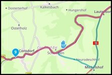
1789195743952.jpg

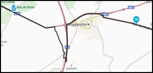
I am looking at the MRA route planned with "Here" maps, the imported track and a comparison with Here and Tom Tom, the reason for this deviation is that "Here" maps refuses to go along that bit of road with waypoint 10 - it has done for years, you can add as many shape points as you like, turn off seasonal closures, but here inists it is not passable.

A bit of effort to get the track showing, worth asking MRA support, they might say they will always match so it is pointless???

I will run some more tests on some of my longer routes now and see if I can find any differences, although I may need to start remving shape points as most my routes have gone through this comparison to iron out any differences from Here <> Tom Tom <>OSM already.

Final point - most modern navigation devices / apps are capable of using "live" traffic and road closure info, so despite all of this you may find on the day things change a bit, here is an example I found recently
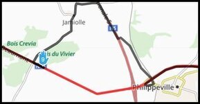
1789196324565.jpg

A quick google gave details of major roadworks, Here maps is aware and routes around it, Tom Tom (Red) and OSM do not show it in the maps, maybe on the day they would? Maybe they would just drive you right up to the blocked road?

 

Attachments

  • 1789196171238.jpg
    1789196171238.jpg
    15.3 KB · Views: 2
Last edited:
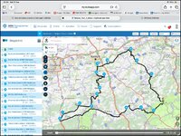
It’s dead easy to display a track and a route together in MyRoute’s cloud based Routeplanner app. Here’s how:

Start with a route:

IMG_0594.jpg

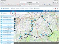
Tap on the hamburger in the upper left corner:

IMG_0595.jpeg

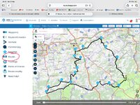
Tap on Routes:

IMG_0596.jpeg

Tap around in your library to find the track(s) or route(s) you want to display. You can have multiples of each, each coloured differently. You can also change the colour of each, if you want to.

Here’s a purple coloured Luxembourg track I have added to the original Belgian route, coloured black:

IMG_0600.jpg

Here’s a sample of several routes or tracks all superimposed on top of each other.

I started by simply creating a ‘route’ with only one point on it, being the town of Clervaux. I then added the routes / tracks on top:

IMG_0601.jpg


Zoom out a bit and the Belgian ‘Breweries route’ will appear.

Tap around….. you can’t break it.
 
Last edited:
Yes, but if I create a "ROUTE" there will not be a corresponding track, I have to export the route as a track to a GPX and then import the GPX track back in before I get a Track of the route I have just created to compare with ;-)

I am sure the MRA people will be thinking "why the fuck would anyone want to do that", but there are use cases.
 
It’s dead easy to display a track and a route together in MyRoute’s cloud based Routeplanner app. Here’s how:

Start with a route:

View attachment 538215

Tap on the hamburger in the upper left corner:

View attachment 538217

Tap on Routes:

View attachment 538218

Tap around in your library to find the track(s) or route(s) you want to display. You can have multiples of each, each coloured differently. You can also change the colour of each, if you want to.

Here’s a purple coloured Luxembourg track I have added to the original Belgian route, coloured black:

View attachment 538219

Here’s a sample of several routes or tracks all superimposed on top of each other.

I started by simply creating a ‘route’ with only one point on it, being the town of Clervaux. I then added the routes / tracks on top:

View attachment 538220


Zoom out a bit and the Belgian ‘Breweries route’ will appear.

Tap around….. you can’t break it.
Yep, that’s what I did, as above. I faffed around trying to do it in the app, but the route planner is the only way. To use it you need to have both the track and the route created.

BTW, I’ve experienced the issue Rasher mentioned a couple of times where MRA
simply would not route through a particular points- both mountain passes.
I think I solved it by using OSM maps instead of Here maps.
 
faffed around trying to do it in the app, but the route planner is the only way. To use it you need to have both the track and the route created.

Yup, it’s only possible via MyRoute Routeplanner, as far as I know.

Yup, Routeplanner can only find and use tracks or routes held on your library.
 
I’ve experienced the issue Rasher mentioned a couple of times where MRA
simply would not route through a particular points- both mountain passes.
I think I solved it by using OSM maps instead of Here maps.

When you come to use the route, you might see a message flash up that the route was created in a different map, or something like that.
 
BTW, I’ve experienced the issue Rasher mentioned a couple of times where MRA
simply would not route through a particular points- both mountain passes.
I think I solved it by using OSM maps instead of Here maps.
Yes, then you will also find on the device it may route differently, I typically try Tom-Tom when here goes wrong, OSM seems to really like the shortest routes often leaving main roads around towns and cities and sending you through housing estates and industrial areas just to save a few meters off your travel distance, I kind of think it would be great for cyclists.
 
Here is a SUREFIRE way of not making mistakes - with the caveat that you are still relying on inevitably flawed map data.

Plan your route ON your satnav.
Simply put = minimal coq-au-vin moments.

Reading so many satnav related issues on here and elsewhere there seem to be a huge reliance on second/ third/fourth and Lord knows what software/gadgets, then add in some converters, making a right soup of what is a basic job.
Each of those inevitably introduce layer upon layer of potential errors giving rise to the 'it doesn't look anything like on my computer' headaches.

Seems to me that many have forgotten the 'KISS' principle but if that is what floats your boat- paddle on!
 
Mmmm.... looks like my suggestion has gone AWAL...
Never mind, coat & M'off :judge...
 
Take / use an iPad. It’s great for MyRoute Routeplanner, along with other app’s such as Kurviger.

:beerjug:
I have been doing, but it’s still a big old lump to carry and with the new MRA device limit I can either use the iPad or my back up
android but not both.

On this trip we are on GS Basics and there’s not a lot of luggage space.


Back
Top Bottom