another point on the above it goes without saying that your preferences will need to be the same in both mapsource and basecamp to do this seamlessly, without an alteration of the route taking place.


You are using an out of date browser. It may not display this or other websites correctly.
You should upgrade or use an alternative browser.
You should upgrade or use an alternative browser.
Shaping Points Advice
- Thread starter Becksy
- Start date
The Grey One
Registered user
........................
Just as a point of interest to those who use mapsource, if you do want to turn on and off announcements in a route you have created in mapsource you could just copy and paste the route into basecamp and do it from there and then just copy and paste it back into mapsource to send it. Sorry my mistake, the last bit is incorect and should have read copy itYou don or send it to your map folder on your unit and not into mapsource. or just send from basecamp.
Actually you don't need to do anything to make Mapsource via points unannounced, they become so automatically. Just one of the many reasons I prefer it to Basecamp You might need to do this if you want them announced but not if you are happy with them being unannounced.
John
Leedude thanks for trying that same route from Mapsource. I think it therefore means that it is down to the units themselves then. For me it confirms that I shall continue to use Basecamp as for the majority of my runs it works really well. I regularly make local runs up in the Peak District even though I know just about every pebble on every road . This is to ensure that the 590 is behaving. I have had more routing anomalies with this over the 660.
With the problems you have encountered,when this has happened on our trips ,we pan out navigate back to route and turn the beggars off and back on. If this fails,have deleted route and reloaded from memory card. This usually works, if not old school list of waypoints map.New route to there,all part of the trip. Someone on here suggested having a track and a route showing to define any GPS nonsense. Also from that New England Rider GPS info they recommended having unit and software on car. Seems to be less glitchy like that.
Andrew
. This is to ensure that the 590 is behaving. I have had more routing anomalies with this over the 660.With the problems you have encountered,when this has happened on our trips ,we pan out navigate back to route and turn the beggars off and back on. If this fails,have deleted route and reloaded from memory card. This usually works, if not old school list of waypoints map.New route to there,all part of the trip. Someone on here suggested having a track and a route showing to define any GPS nonsense. Also from that New England Rider GPS info they recommended having unit and software on car. Seems to be less glitchy like that.
Andrew
Actually you don't need to do anything to make Mapsource via points unannounced, they become so automatically. Just one of the many reasons I prefer it to Basecamp You might need to do this if you want them announced but not if you are happy with them being unannounced.
John
this is indeed correct. but if you wanted to make your via points announce say on a route that was sent to you from a third party that had been made in mapsource you could use the method as described, no need to put it back in mapsource to change the points to waypoints, or a person may not even have mapsource to do this, and may wonder if it is possible. just pointing this out like you said, was an attempt to add something to the findings
Leedude thanks for trying that same route from Mapsource. I think it therefore means that it is down to the units themselves then. For me it confirms that I shall continue to use Basecamp as for the majority of my runs it works really well. I regularly make local runs up in the Peak District even though I know just about every pebble on every road
With the problems you have encountered,when this has happened on our trips ,we pan out navigate back to route and turn the beggars off and back on. If this fails,have deleted route and reloaded from memory card. This usually works, if not old school list of waypoints map.New route to there,all part of the trip. Someone on here suggested having a track and a route showing to define any GPS nonsense. Also from that New England Rider GPS info they recommended having unit and software on car. Seems to be less glitchy like that.
Andrew
as i said in an earlier post, like you i prefer to handle recalculation on my own, and like you i just zoom out and find away around the problem, others may do something else.
using a track and a route together is a good way of seeing how and where your route and track differ from one another, as a track is fixed item it will remain as is when on the unit. I can not make a definate comment about the reason for having the unit and software set to car mode, as one i dont have a 590, and two i have always used the motorcycle preference on both the nav and software, with it set to how i want it to be. In the end Andrew we all go about this the way that suits us best, and its been said many times there is no wrong or right way.
We all just trying to help one another
In the end...we all go about this the way that suits us best
And that says it all.
In 2,700 miles of self-created BaseCamp routes around Germany, I had two glitches:
1. That I made myself, when I mistakenly placed a shaping point at what I thought was a viewpoint but was not. A one mile deviation to look at a farmyard, was what I got. Had I not thought about going to see it, it would not have occurred.
2. The second was a bizarre re-routing in a town, when I encountered roadworks. I pushed recalculate in the deviation itself, just to see what happened. Had I just done what I normally do - which is to just leave the device alone and just navigate myself back to the route I had painstakingly created - then I would not have had that either.
As I rarely if ever ride a route that has not been bespoke created by me in BaseCamp on my Mac computer, equally rarely ever relying on the device to create a route for me and backed by a reasonable level of self-confidence to get myself out of a navigational hole, I have no great need to ever employ any recaclation functions at all. The mysteries of them I'll now leave to everyone else, as I am quite happy.
OK I had to try this out for myself so already had a test route built from testing the 590 earlier this year.
Route consists of start and end waypoint with multiple shaping points between. I also laid a track onto the map of the route so while i
went off route a i could still see where the original route was, If you get what i mean. Motorcycle mode although i doubt this is relevant.
Re calculate set to prompt, however when it did prompt me (when i deliberately went off route) i tapped yes to recalculate every time.
My results reflect exactly the same as Becksy and Leedude03 amazingly the device wont release the shaping point until you get back
on the magenta, only after the deviation back to the shaping point further along the route if you get what I mean.
(If you zoom the map out you get a clearer picture of what's going on) Which would be at a point extremely close to the next shaping point or just after it.
So if your recalculate is set to auto, you'll be un-wittingly riding around in circles all day!!
good to hear from another source, and glad you tried it for yourself as in post number 10 on this thread you were unsure, and presumably were not to sure to take my word for it, and neither would i, as we were dealing with different units. with your 590 i believe there is a skip function that maybe able to cancel this problem out for you.
The major problem with the unit doing this is, if you have large distances between points, and you mistakenly think the unit knows better by taking you back, and you let it carry on you could be miles away from where you want to be, as others have said they were given a bizzare route after a recalculation.
As a side note i believe the humble zumo 550 does not do this, probably because its not as clever as the newer units, i would need to do a couple of more tests to make sure, but from the first test i did it just carried on along the route once back on it, and didnt ask me to go backwards, this may of course have been because the unit was not recalculating quick enough.
good to hear from another source, and glad you tried it for yourself as in post number 10 on this thread you were unsure, and presumably were not to sure to take my word for it, and neither would i, as we were dealing with different units. with your 590 i believe there is a skip function that maybe able to cancel this problem out for you.
Not that I didn't believe you
I had in my mind a view of how I thought it works whereas reality of how it actually works is slightly different but good to know/understand how it handles shaping points.As for skip function yes could have tried it (I may do a re run and try it) thought it was only for Waypoints


The Grey One
Registered user
.........................
So if your recalculate is set to auto, you'll be un-wittingly riding around in circles all day!!
I must be doing it wrong! I always have auto recalculate on and so far I have avoided going around in circles, unless I use the motorcycle mode-
John
Here goes....
Given Lee's findings, I think that the newer devices might well take their owners back through a shaping point that's been missed, for one simple reason... because they can. The default position for the newer Garmin GPS units is the use of waypoints and then the 'skip waypoint' and 'diversion' functions, which will correct what is ostensibly an error. Why? Because that is how most bods create their routes, so Garmin have only responded to the wishes of the masses. It appears from Lee's investigation (over quite small distances between points) that the conversion of announced waypoints into unannounced shaping points, might leave a vestige of data with it, telling the device that you did want to pass that point and head down the road before and after that point; so that is what it does. Whether or not there is some magical distance algorithm that tells the device to ignore a missed shaping point if it is more than X miles away I have no idea. Somehow I doubt it, not least as the missed shaping point might conceivably be in front of the rider, not behind. Lots of bods would be very pee'ed off it starts to miss out shaping points ahead of them on the road, just because they turned off the magenta route into a garage to buy fuel.
Not least, Garmin have pandered to the "Give me a windy road route betweeen A and B, with no motorways" brigade who do no route creation of their own. To these people it matters not how or why a device recalculates a route should they stray from the magenta line. Indeed, they want and need it to continually recalculate for them or they would never get to their end destination at point B. Similarly, some (often the same) bods love waypoints, wrapped in a security blanket of being sure that, no matter what else happens, they will always be sure to arrive at that special restaurant or car park to meet with like minded souls.
Me? I'll continue to plot my own routes, use a waypoint or shaping point if it suits me and I'll continue (in a Faustian pact with myself) to avoid recalculation, just as I've always done. Ping me a message when it's all sorted out, please.
Not that I didn't believe you
As for skip function yes could have tried it (I may do a re run and try it) thought it was only for Waypoints
I can not be of any help to you with the 590 as I don't have one, this is just what I have read.
I must be doing it wrong! I always have auto recalculate on and so far I have avoided going around in circles, unless I use the motorcycle mode-
John
It may be of some interest to people, if you gave a few details as to what your preference settings are , just In case others wish to try them, to avoid this particular issue
The Grey One
Registered user
It may be of some interest to people, if you gave a few details as to what your preference settings are , just In case others wish to try them, to avoid this particular issue
I though I had done that before but here goes-
Firstly I always use Mapsource to plan my routes. I always have my start and end points as waypoints and usually let Mapsource produce a route by highlighting the two waypoints and right clicking on the "create route from the selected waypoints" option. I then drag and drop the route to pick the roads I want. This creates unannounced via points used to ensure the device follows my wishes. These points are usually placed just after a junction for this purpose. For bike routes I have the road selector set in the middle, for car routes I sometimes move it more towards the prefer highways end of the scale.
I use two devices, a 390 on the bike or my car and a nuvi 2497 in my wife's car. The 390 is usually set to avoid motorways and unmade roads. the 2497 just to avoid unmade roads. Both are set to fastest time and have auto recalculation turned on. Both perform as I would expect and cope with missing via points without insisting I turn around. Both devices have the latest Garmin mapping plus OSM maps. I usually use OSM mapping on the 390 and Garmin on the 2497. The OSM maps are far more accurate and detailed but my wife uses her car for work and needs the post code search facility that is not available on the OSM maps. Having said that I often have to use OSM maps with mapsource to pinpoint destinations, make a waypoint and then transfer that to the Garmin maps. If we use my wife's car for trips I used OSM maps
The only problems I have experienced are when I switched the 390 into motorcycle mode. Every time I have tried this mode I get problems. These range from the insistence on picking tiny lanes over much faster B roads to trying to send me on 50 mile diversions for no apparent reason. I have posted on here about some of these problems. I am convinced that there are some hidden settings that are used when the motorcycle mode is engaged. I have tried several times with what settings there are set exactly the same in both car and motorcycle mode only to find that using the motorcycle mode causes the route to calculate differently.
Also when in motorcycle mode the auto recalculate function becomes erratic, often sending me down miles of narrow gravel strewn lanes rather than more direct roads back to the intended route. On the last occasion this would have added nearly and hour to a 90 min journey had I blindly followed the directions. I stopped, switched back to car mode, and it came up with a more logical route straight way. Leaving the 390 in car mode is the solution but, as I have said before, a great shame as the ability to switch between two different sets of setting would be very useful.
John
Thank you John, I didn't know you had posted it before, but I feel sure some people will take something from it. I may have a play with testing both settings to see what happens.
The only problems I have experienced are when I switched the 390 into motorcycle mode. Every time I have tried this mode I get problems. These range from the insistence on picking tiny lanes over much faster B roads to trying to send me on 50 mile diversions for no apparent reason. I have posted on here about some of these problems. I am convinced that there are some hidden settings that are used when the motorcycle mode is engaged. I have tried several times with what settings there are set exactly the same in both car and motorcycle mode only to find that using the motorcycle mode causes the route to calculate differently.
Also when in motorcycle mode the auto recalculate function becomes erratic, often sending me down miles of narrow gravel strewn lanes rather than more direct roads back to the intended route. On the last occasion this would have added nearly and hour to a 90 min journey had I blindly followed the directions. I stopped, switched back to car mode, and it came up with a more logical route straight way. Leaving the 390 in car mode is the solution but, as I have said before, a great shame as the ability to switch between two different sets of setting would be very useful.
John
Interesting post. Exactly my experience, too. You mention hidden settings...
I'm more tempted to suggest there are different algorithm values placed (possibly by Garmin?; or the digital mappers?) on the roads themselves. (I hope that makes sense...) and when the route calculation summation takes place - a whacky route is the result.
The oddball behaviour seems to change with each mapset update, too; which is why I think it's the mapping rather then the device.
I've seen the device knock out a deviant route taking me on an obvious wild turkey hunt round a dead-end housing estate, re-emerging on exactly the same road and then head off past the start/origin point towards the destination. Curiously, this only happens in motorcycle mode. I even took a screenshot to send to Garmin for their comments, but never gotten round to it. This erratic behaviour is tolerable if you have a knowledge of the roads or area; however, when the device pulled some similar stunts tootling through darkest France, last year, it was tedious and frustrating.
The Grey One
Registered user
Interesting post. Exactly my experience, too. You mention hidden settings...
I'm more tempted to suggest there are different algorithm values placed (possibly by Garmin?; or the digital mappers?) on the roads themselves. (I hope that makes sense...) and when the route calculation summation takes place - a whacky route is the result.
The oddball behaviour seems to change with each mapset update, too; which is why I think it's the mapping rather then the device.
I've seen the device knock out a deviant route taking me on an obvious wild turkey hunt round a dead-end housing estate, re-emerging on exactly the same road and then head off past the start/origin point towards the destination. Curiously, this only happens in motorcycle mode. I even took a screenshot to send to Garmin for their comments, but never gotten round to it. This erratic behaviour is tolerable if you have a knowledge of the roads or area; however, when the device pulled some similar stunts tootling through darkest France, last year, it was tedious and frustrating.
I too have found that things change but I suspect it is down to changes in device software. I keep my devices updated and have found subtle differences after some updates. Whilst it may be something in the maps the fact that I get the same erratic routing using OSM maps does tend to throw doubt on that theory
John
Very helpful analysis by everyone. I think in my mind it's clear how shaping points work, though next time will switch to planning in car mode and see what happens, though I don't think that makes much difference on a Nav V, we shall see. Joe Biff makes an interesting point on mapping, see this article in The Times the other day
http://www.thetimes.co.uk/article/sat-nav-that-knows-every-wrong-turn-to-unblock-britain-d89k8jcpt
Sent from my iPad using Tapatalk
http://www.thetimes.co.uk/article/sat-nav-that-knows-every-wrong-turn-to-unblock-britain-d89k8jcpt
Sent from my iPad using Tapatalk
The Grey One
Registered user
Very helpful analysis by everyone. I think in my mind it's clear how shaping points work, though next time will switch to planning in car mode and see what happens, though I don't think that makes much difference on a Nav V, we shall see. Joe Biff makes an interesting point on mapping, see this article in The Times the other day
http://www.thetimes.co.uk/article/sat-nav-that-knows-every-wrong-turn-to-unblock-britain-d89k8jcpt
Sent from my iPad using Tapatalk[/QUOTE
Planning the route in car mode is one thing, you will need to check that your device does not change it back to motorcycle mode if that is how the device is usually set. As I use Mapsource my routes do not have modes attached when they are transferred to the device but if I set a route to motorcycle mode on the device it will remain that way even if I switch the main device setting to car. This seems logical and would be useful if the motorcycle mode worked properly. It would allow a selection of routes with different settings, you could have two versions of the same route and switch between at will.
As for the article about truck drivers , aren't a lot of those problems due to users not setting the device for the right type of vehicle. Both Basecamp and Mapsource have vehicle settings for trucks and I suspect devices sold for use in truck have such settings too. Are they used?
John
I though I had done that before but here goes-
Firstly I always use Mapsource to plan my routes. I always have my start and end points as waypoints and usually let Mapsource produce a route by highlighting the two waypoints and right clicking on the "create route from the selected waypoints" option. I then drag and drop the route to pick the roads I want. This creates unannounced via points used to ensure the device follows my wishes. These points are usually placed just after a junction for this purpose. For bike routes I have the road selector set in the middle, for car routes I sometimes move it more towards the prefer highways end of the scale.
I use two devices, a 390 on the bike or my car and a nuvi 2497 in my wife's car. The 390 is usually set to avoid motorways and unmade roads. the 2497 just to avoid unmade roads. Both are set to fastest time and have auto recalculation turned on. Both perform as I would expect and cope with missing via points without insisting I turn around. Both devices have the latest Garmin mapping plus OSM maps. I usually use OSM mapping on the 390 and Garmin on the 2497. The OSM maps are far more accurate and detailed but my wife uses her car for work and needs the post code search facility that is not available on the OSM maps. Having said that I often have to use OSM maps with mapsource to pinpoint destinations, make a waypoint and then transfer that to the Garmin maps. If we use my wife's car for trips I used OSM maps
The only problems I have experienced are when I switched the 390 into motorcycle mode. Every time I have tried this mode I get problems. These range from the insistence on picking tiny lanes over much faster B roads to trying to send me on 50 mile diversions for no apparent reason. I have posted on here about some of these problems. I am convinced that there are some hidden settings that are used when the motorcycle mode is engaged. I have tried several times with what settings there are set exactly the same in both car and motorcycle mode only to find that using the motorcycle mode causes the route to calculate differently.
Also when in motorcycle mode the auto recalculate function becomes erratic, often sending me down miles of narrow gravel strewn lanes rather than more direct roads back to the intended route. On the last occasion this would have added nearly and hour to a 90 min journey had I blindly followed the directions. I stopped, switched back to car mode, and it came up with a more logical route straight way. Leaving the 390 in car mode is the solution but, as I have said before, a great shame as the ability to switch between two different sets of setting would be very useful.
John
Well John what can i say, I tried your settings this morning when taking the big gal to work, and i have to say i got exactly the same results as i did when the nav was in motorcycle mode, it tries to route back to a missed waypoint and also tries to route back to a shaping point, i can only guess at why, i may have slightly different settings in mapsource or on my 660, or your nav handles things differently.
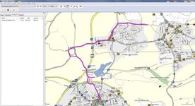
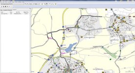
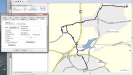
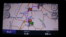
I have posted picks of the route along with the track i took showing me going back as instructed by the nav, and also pictures of settings in mapsource and a picture of the route on the nav showing announced points.
I did ignore the first two times it recalculated but the third time i followed the instructions and the track is the result.
A couple of thoughts maybe its to do with the mapping i presume you are using NTU maps and mine are NT, I did not have my unit in the cradle at any point in these tests.
other than that I am a bit stumped as to why we both have totally different results
Attachments

Similar threads
- Replies
- 9
- Views
- 734
- Replies
- 4
- Views
- 677
- Replies
- 8
- Views
- 1,373